
Darwin Mining District, Darwin Hills, Inyo County, California, USAi
| Regional Level Types | |
|---|---|
| Darwin Mining District | Mining District |
| Darwin Hills | Group of Hills |
| Inyo County | County |
| California | State |
| USA | Country |
This page is currently not sponsored. Click here to sponsor this page.


Latitude & Longitude (WGS84):
36° 16' 0'' North , 117° 34' 2'' West
Latitude & Longitude (decimal):
Type:
Köppen climate type:
A W-Ag-Pb mining area located principally in secs. 11-14, 23-25, T19S, R40E, MDM, around Darwin and the Darwin Hills.
The Darwin lead-silver-zinc district comprises the area of the Darwin Hills within the Darwin Plateau of west central Inyo County, California. The district has produced over $29 million in lead, silver, zinc, tungsten, and copper. Ore bodies occur as structurally controlled replacement and fissure filling deposits within a contact metamorphic calc-silicate aureole developed within Keeler Canyon Formation limestones surrounding the intrusive Darwin quartz monzonite stock.
While there were many mines and prospects within the Darwin District, most of the district's production has come from the larger and more important workings on the west side of the Darwin Hills which were ultimately consolidated and operated by the Anaconda Company as the Darwin Mine. These included the Bernon, Defiance, Essex, Independence, Intermediate, Rip Van Winkle and Thompson workings. Since little information is available about the many earlier workings, Anaconda's Darwin Mine workings are considered typical of the district for the purpose of this report. Paleozoic rocks on the east side of the Darwin Hills also harbor several smaller tungsten deposits which have been sporadically developed in years past but are not considered in this report. No mines in the district are currently active.
The district is particularly famous for scheelite crystals. The old report that stolzite occurs from this locality was substantiated by Moore (2006). The opaque gray specimens of "scheelite" may be mostly pseudomorphs of stolzite after scheelite, while the transparent to translucent crystals which fluoresce blue white in short wave ultraviolet are probably perfectly good scheelite.
The Darwin District includes many individual mines and prospects distributed throughout an area encompassing approximately 9 square miles in the Darwin Hills within the western margin of the Basin and Range geoprovince. Since the mines are within the Darwin Hills of which Ophir Mountain is the highest point, this mountain was chosen to represent the district location. The location latitude and longitude identify the 6,010 feet peak of Ophir Mountain on the USGS Darwin 7.5 minute quadrangle (approximately the southwest corner of Sec. 12-T19S-R40E). The Darwin District is 39 miles from the town of Lone Pine in the Owens Valley. It is reached by taking State Highway 136 east to the intersection of State Highway 190 at the south end of dry Owens Lake, then proceeding on Highway 190 approximately 13 miles to the Olancha Darwin Road turnoff. Turn south on Olancha Darwin Road and travel 5 1/2 miles to the ghost town of Darwin at the foot of the Darwin Hills. The mine workings are located just northeast of the town on the flanks of the Darwin Hills.
Ore bodies include: Pipes, tabular, and lenses.
Mineralization within the district occurs in various deposits:
- Ag, Pb, W occur in bedded and irregular replacement deposits and in vein deposits.
- Zn occurs in replacement deposits within and adjacent to faults and fractures
Ore Materials:
- Silver and lead ore minerals: Argentiferous galena, tetrahedrite, enargite, pyrrhotite, chalcopyrite, andorite, frankeite, stannite.
- Zinc ore mineral: Sphalerite
- Tungsten ore mineral: Scheelite.
Host rocks include calc-silicate schist of the Keeler Canyon Formation (Early Permian - Middle Pennsylvanian). Associated rocks include Middle Jurassic biotite-quartz monzonite (Darwin stock). Local rocks include Carboniferous marine rocks, unit 2 (SE California Carbonate Assemblage).
Local geologic structures include the Darwin Hills Anticline, Davis Thrust Fault, Standard Fault, and the Darwin Tear Fault. Regional features include the Swansea-Coso Thrust System, Darwin Wash Syncline, and the Darwin Tear Fault.
Approximately 94% of California's lead production and 28% of California's zinc production has come from polymetallic lead-silver-zinc deposits in the western Basin and Range province which includes the Death Valley region and most of Inyo County. The majority of deposits in California lie in a northwest-southeast trending mineralized belt extending from the Inyo Mountains southeast through the Argus Range to the Nopah Range. The bulk of production comes from three leading mining districts within this trend; the Darwin District, the Cerro Gordo District in the southern Inyo Mountains, and the Tecopa District at the south end of the Nopah Range east of Death Valley. The Darwin District ranks first in mineral production, followed by the Cerro Gordo and Tecopa districts.
Silicified limestone, in the form of calc-hornfels and tactite is the host rock for the lead-silver-zinc deposits. At Darwin, Paleozoic beds of the Permo-Pennsylvanian Keeler Canyon Formation were folded, overturned, faulted, and locally metamorphosed during emplacement of the nearby Coso Range batholith and satellite Darwin stock. The main structural feature of the Darwin District is a north trending overturned syncline intruded by the quartz monzonite Darwin stock near its axis and complexly faulted. Intrusion of the stock into the overturned syncline resulted in a contact metamorphic aureole consisting of calc-silicate minerals peripheral to the intrusive which was later faulted and fractured prior to mineralization. The Davis Thrust Fault strikes northerly along the west side of the Darwin Hills and confined mineralization to the rocks in the footwall between the fault plane and the Darwin stock to the east.. Later introduction of ore solutions created structurally controlled ore bodies which include bedded replacement deposits, irregular replacement bodies, and fissure deposits along faults and fractures within the altered carbonate country rocks. Proximity to faults and intrusive contacts was largely responsible for ore body localization with most ore bodies near N 50? -70? E striking feeder faults.
The primary hypogene sulfide ores are argentiferous galena, sphalerite, and chalcopyrite. Gangue minerals include calcite, fluorite, pyrite, and pyrrhotite. A zone of rich oxidized ore extends form the surface to almost 1,000 feet with cerrusite and hemimorphite being the main ore minerals.
Environment The Darwin District is an area of low arid hills (Darwin Hills) within the Darwin Plateau in west central Inyo County. It is located midway between the highest point (Mt. Whitney @ 14,496 feet) and the lowest point (Badwater in Death Valley @ -282 feet) in the contiguous United States, approximately 40 miles west and east respectively. The district is centered around the Darwin Hills, which displays a peak elevation of 6,010 feet at Ophir Mountain, It is surrounded by the Inyo Mountains (max. elev. 9,183') to the north, the northwest flank of the Argus Range to the east (max. elev. 8,839') and the northeast flank of the Coso Mountains (max. elev. 8,160'). The China Lake Naval Weapons Center borders the district to the south.
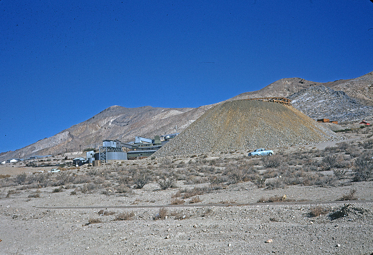
The area is sparsely populated. The town of Darwin, which once supported the thriving district, has a current population of about 40 and consists of a scattering of mostly unoccupied dilapidated wooden buildings and cabins. The old mill buildings and the extensive company housing complex of the Anaconda Darwin mining camp were removed in the 1990s. Most of the historic mine workings are on public lands administered by the BLM or on patented claims. After cessation of mining in the late 1970s as many as 72 patented claims and 230 unpatented claims were on file with the BLM. The next largest town, Lone Pine (pop. 1,660) is 39 miles northwest.
Vegetation consists of sparse creosote bush, cacti, and Joshua trees. In the neighboring Argus and Coso Ranges
pinon pine and juniper are also common.
The climate is arid high desert. Total annual precipitation is 6.67 inches at Haiwee Station (14 miles west). Average summer high temperature is 95.3? in July and average low temperature 28.8? degrees in January. Daily temperature fluctuations can be extreme
Drainage is into the Panamint Valley. The Darwin Hills are drained by Lucky Jim Wash and Darwin Wash on the west and east respectively. South of the Darwin Hills, Lucky Jim Wash joins Darwin Wash which flows northward through Darwin Canyon into the Panamint Valley.
The Darwin District is primarily a lead-silver-zinc district located in the Darwin Hills along a zone of mineralization near the east margin of the Coso Range batholith. Lead, silver, and zinc deposits are concentrated on the west side of the Darwin Hills and several tungsten deposits are located on the eastern side. The majority of the district's production has come from structurally controlled replacement ore bodies within silicified limestone of the lower member of the Permo-Pennsylvanian Keeler Canyon Formation.
REGIONAL SETTING
The Darwin District is one of several lead-silver-zinc districts in a mineralized trend extending over 100 miles from the Cerro Gordo District in the southern Inyo Mountains to the Tecopa District in the Nopah Range of southeastern Inyo County. The smaller Ubehebe, Modoc, and Panamint districts are also included within this mineralized trend. The Darwin region includes some of the most important lead-silver-zinc mines in the state as well as the largest steatite-talc producing area in the state in the Talc City Hills near the south end of the Inyo Mountains.
The Darwin District lies on the western fringe of the Basin and Range geoprovince which is characterized by Cenozoic age northwesterly trending parallel mountain ranges separated by structurally controlled valleys. The district is located within the Darwin Plateau and surrounded by the Inyo Mountains, the Coso Range, and the Argus Range. Regionally, the area is drained into two closed basins, the Panamint Valley to the east and Owens Lake to the west.
Stratigraphy
The rock record in the Darwin region consists of Ordovician through Permian miogeoclinal sedimentary rocks, Mesozoic plutonic rocks, and Cenozoic volcanic rocks and sediments. The Ordovician - Permian section consists of over 14,000 feet of carbonate rocks in which pre-Mississippian rocks are largely dolomite and Mississippian through Permian rocks are primarily limestone (Hall and MacKevett, 1958). The Paleozoic marine sequence was deposited in the thick Precambrian-Paleozoic miogeoclinal wedge that formed on the passive continental margin, and later thrusted eastward as allochthonous thrust sheets during the Antler and Sonoma orogenic events.
Ordovician beds are exposed in outcrop in the Talc City Hills (6 miles northwest of Darwin) where the Early-Middle Ordovician Pogonip Group dolomite is overlain by the middle Ordovician Eureka Quartzite. The thick bedded late Ordovician Ely Springs dolomite overlies the Eureka Quartzite. Silurian-Devonian rocks are represented by of the Hidden Valley Dolomite and the Lost Burro Formation which is exposed on the east side of the Talc City Hills and on the west flank of the Darwin Hills where it consists primarily of dolomite, quartzite, shale, and chert.
The Mississippian Tin Mountain Limestone and the upper Mississippian Perdido Formation both outcrop on the west flank of the Darwin Hills. The Tin Mountain is composed of gray fossiliferous and cherty fined grained limestone. The Perdido Formation resembles the Tin Mountain Limestone but contains thick continuous chert beds and lacks the abundant fossils. The Mississippian-Pennsylvanian Lee Flat Limestone rests conformably of the Perdido Formation.
The Pennsylvanian Rest Spring Shale is present only in in the northern Darwin Hills and the Talc City Hills. Considered by some workers to be the stratigraphic equivalent of the upper Lee Flat Limestone (McAllister, 1952), the unit is generally thin (0-50 feet thick).
The Permo-Pennsylvanian Keeler Canyon Formation is a thick (4,000? ft.) limestone unit that can be divided into upper and lower members (Hall and MacKevett, 1958). The lower member (2,300? ft.) is composed predominantly of bluish-gray Pennsylvanian limestone. The lead-silver-zinc deposits of the Darwin District are associated with a metamorphosed and silicified section of the lower member where it has been folded and intruded by the Darwin quartz monzonite stock. The lower Keeler Canyon member outcrops throughout most of the Darwin Hills. The upper member is composed of pink shale, silty limestone and limy siltstone.
The youngest Paleozoic rock units include calcarenite, silty limestone, pure limestone, and shale of the Permian Owens Valley Formation. These units are exposed throughout much of the Darwin area and underlie the east side of the Darwin Hills, Darwin Canyon, and the west flank of the Argus Mountains.
Regionally, the Paleozoic section was intruded by several Mesozoic bathloliths and plutons. These include the Hunter Mountain batholith to the northeast , Coso Range batholith to the southwest, and the satellite stock at Darwin Hills where biotite-hornblend quartz monzonite is the primary rock type. Stocks at Talc City Hill and Zinc Hill in the Argus Range are composed of leucocratic quartz monzonite. The Coso Range intrusion which has been dated 154-156 m.y. (Dunne and others, 1978) as well as plutons in the Argus Range, are considered to be Sierra type batholiths that are coeval satellites of the Sierra Nevada batholith.
Tertiary and Quaternary sedimentary deposits abound. Much of the area is covered by Plio-Pleistocene fanglomerates which flank the Inyo Mountains and the Coso and Argus Ranges, and by lacustrine beds of ash, silt, and clay in the Darwin Wash area.
During the Cenozoic, regional extension produced widespread normal and strike-slip faulting, volcanism, and shallow intrusive activity. Cenozoic volcanic rocks are common north of Darwin in the Inyo Mountains, Santa Rosa Hills, and on parts of the Darwin Plateau. Pyroclastic basaltic rocks rest unconformably on the Paleozoic sedimentary rocks and granite in the Inyo Mountains and layered olivine basalt flows cover a much of the area ranging from 10 to 100 feet thick (Hall and MacKevett, 1958).
Regional structure
Structural features are the result of several periods of deformation in the western Basin and Range including Mesozoic folding and faulting which dictated the overall structural fabric of the Paleozoic rocks, and late Cenozoic faulting which produced the present Basin and Range topography.
Dunne and others (1978) recognized three major pulses of Mesozoic deformation in the general area of the White, Inyo, Slate, and Argus ranges. However, the most significant in terms of the Darwin region was of mid to late Jurassic age and associated with the Nevadan Orogeny. Deformation is reflected in the Swansea-Coso Thrust System, a thrust belt characterized by generally high angle thrusts with little lateral slip that extends almost continuously from the southern Inyo Mountains to the Slate Range. This deformation was associated with the emplacement of the Sierra Nevada batholith and many coeval satellite plutons in the White and Inyo Mountains and the Coso batholith.
The Paleozoic rocks were compressed into a series of broad open northerly trending folds. The major fold in the Darwin area is the Darwin Wash Syncline, a broad syncline which trends N 20? W and is located just east of the Darwin Hills in Darwin Wash. The east limb of the syncline occurs as a dip slope on the west flank of the Argus Range. The west limb is largely obscured by alluvium in Darwin Wash but is exposed in the low hills at the north end of the wash.
During emplacement of the Nevadan intrusives such as the Coso Range batholith, adjacent bedding was severely deformed. The gently folded strata was forcefully intruded and further deformed in and adjacent to the Darwin Hills as older strata was forced upward by the intrusion, overturned, tightly folded, and faulted. Thrust faulting was associated with the emplacement of the Coso batholith and is localized along the east margin of the batholith. The largest of these is the Davis Thrust in the Darwin Hills which exhibits eastward thrusting. The Davis thrust strikes northerly through the Darwin Hills and is an important control in the deposition of the Darwin District lead-silver-zinc ores (Hall and MacKevett, 1962). It dips 23? to 60?W. Throw and net slip are unknown. The west limb of the Darwin Wash Syncline is further deformed adjacent to the Darwin quartz monzonite stock where the beds are overturned. The Paleozoic rocks of the Darwin Hills were largely folded and faulted before silication of the limestone around the intrusive body.
Accompanying the thrusting of the Swansea-Coso trend, at least three periods of pre-Cenozoic strike slip faulting occurred. (Dunne and others, 1978). These faults consist of steep high angle left lateral strike slip faults exhibiting mainly a strike-slip displacement. The most pronounced of these are northwest trending sinistral faults and fractures that are present form the Southern Inyo Mountains to the Argus range. The faults and fractures truncates structures as young as the Swansea-Coso Fault system, and they are intruded by dikes of the Independence Dike swarm of late Jurassic age (Dunne and others, 1978).
The largest of these faults in the area is the Darwin Tear Fault, a major northwest-southeast trending sinistral strike-slip fault which offsets the Darwin Wash Syncline near the northern edge of the Darwin Hills. The fault can be traced for almost 10 miles from the Talc City Hills to the Argus Range and exhibits a maximum known displacement of 2,200 feet (Hall and MacKevett, 1958). The Standard Fault, in the Darwin Hills is another example. Additional Mesozoic faulting includes sets of northeasterly trending sinistral faults and northerly striking nearly vertical faults and fractures.
Cenozoic tectonics are responsible for the current topographic features of the Basin and Range. Stewart (1978) believes that back-arc spreading and right hand transform wrenching of the western continental margin is responsible for the characteristic Basin and Range horst and graben topography and extensive volcanic activity. Cenozoic faults are generally northerly striking high angle en-echelon normal faults with their downthrown side to the east, and superimposed on the earlier Mesozoic structures. All the mountain ranges in both the Darwin and adjacent Panamint Butte quadrangle are east tilted fault blocks with adjacent alluvial basins including the southern Inyo, Coso, Argus, and Panamint ranges. A swarm of Basin and Range faults northeast of the Darwin area form the escarpment on the west side of the Panamint Valley where the cumulative vertical displacement is about 2,000 feet (Hall and MacKevett, 1958). Another swarm of faults on the western flank of the Argus range forms a series of step like benches. The cumulative vertical displacement on these faults is 1,600 feet. Extensional tectonics of the basin and range topography began before the late Pliocene as shown by the fanglomerates of that age marginal to the Inyo Mountains and Coso Range.
Ore Deposits
While mines in the Darwin region have produced lead, silver, zinc, talc, tungsten, antimony, copper, gold, limestone, and dolomite, the most important deposits are the lead-silver-zinc deposits that occur along a mineralized belt extending from the Cerro Gordo District southeast to the Tecopa District. Lead-silver-zinc deposits are widely distributed throughout the northern part of this trend. The most productive mines were in the Darwin Hills but smaller deposits have been mined in the Talc City Hills, Zinc Hill, in the Lee District in the Santa Rosa Hills, and at the Santa Rosa Mine in the Inyo Range. Staring in 1941, tungsten was also produced from ore bodies on the east side of the Darwin Hills.
Many of the lead-silver-zinc deposits occur in Pennsylvanian-Permian age limestone host rocks which have been folded and faulted about northerly axes and that have been altered to calc-hornfels and tactites by contact metamorphism and metasomatism peripheral to intrusive igneous bodies. These bodies include a biotite-hornblend quartz monzonite stock in the Darwin District and leucocratic quartz monzonite stocks in the Talc City Hills and at the Zinc Hill Mine. Calc-hornfels were generally formed by recrystallization of impure limestones while tactites resulted from contact metamorphism of the purer limestones. While no particular formations are exclusive to lead-silver-zinc deposits, lithology is an important aspect of ore localization. Limestone beds are more conducive to lead-silver-zinc deposits whereas dolomite and quartzite units are unfavorable. In general, the ores are almost always in altered limestone and marble. In the Talc City Hills, for instance, dolomites and quartzite contain only talc, while only the limy parts of the formation contain lead-silver-zinc deposits. This association also holds true in the Cerro Gordo District to the north (Hall and MacKevett, 1958). Further, certain beds within a particular formation are more conducive to lead-silver-zinc ore deposits that others. In the Darwin District, for instance, a medium grained wollastonite-garnet-idocrase calc-hornfels formed from a fairly pure limestone is highly mineralized while dense, greenish gray calc-hornfels formed from silty limestone is not. Similarly, at the Zinc Hill Mine, all ore bodies are in one favorable marble bed, while other limestone beds are only slightly mineralized (Hall and MacKevett, 1958).
Mineralization is contact metamorphic and metasomatic ranging to mesothermal (Hall and MacKevett, 1962). Individual ore bodies occur in silicified carbonate rocks along the periphery of plutonic rocks as (1) bedded replacements localized near the axes of folds, (2) irregular vertical pipe-like replacement bodies associated with the intersection of faults and fractures, and (3) replacement and filling deposits along faults and fractures. Fault control is apparent for nearly all deposits, although it is only one of several controls in localizing ore (Hall and MacKevett, 1958). Primary ore controls also include proximity to silicic to intermediate plutonic rocks, stratigraphic controls in certain carbonate formations, and association with steeply dipping faults and fractures that served as feeder channels for the ore solutions. Generally fractures are progressively less mineralized away from the faults.
The largest deposits are in the Darwin Hills deposits within in calc-hornfels host rocks of the lower member of the Keeler Canyon Formation. A few smaller deposits in the Talc City Hills also occur within sheared limestone of the Keeler Canyon Formation. Farther north, in the Santa Rosa District of the southern Inyo Mountains, lead-silver-zinc ores are found in calc-hornfels in the Permian Owens Valley Formation. In the Zinc Hill District in the Argus Range replacement ore bodies occur along faults in Mississippian marble. In the Cerro Gordo and Lee districts, replacement ore bodies occur along faults and along bedding planes in the Devonian Lost Burro Formation marbles (Hall and MacKevett, 1962).
Ore Minerals
The primary hypogene ore minerals in the lead-silver-zinc deposits are argentiferous galena (chief lead and silver ore mineral) and sphalerite (zinc ore mineral). Silver is produced as a byproduct of argentiferous galena. Lesser ore minerals are enargite, tetrahedrite, pyrite, pyrrhotite, and chalcopyrite. Minor to very minor occurrences of scheelite, andorite, franckeite, stannite, matildite, bornite, chalcocite, covellite and bismuth are present. Sphalerite is the primary hypogene zinc mineral at the Zinc Hill Mine. Pyrite is abundant in most of the lead-silver-zinc deposits with the exception of the Lee Mine. Scheelite is the primary tungsten ore mineral in the ore bodies on the east side of the Darwin Hills.
Gangue minerals include calcite, fluorite, and garnet with lesser amounts of barite, clay minerals, diopside, idocrase, orthoclase, quartz, jasper, and wollastonite (Hall and MacKevett, 1958). Calcite and fluorite are directly associated with ore minerals whereas garnet, idocrase, diopside, and wollastonite are considered to have been formed by silicification and recrystallization of the limestone before the period of mineralization. In many cases these minerals can be seen replaced by ore minerals.
Metallogeny
Given the clear association of the known lead-silver-zinc deposits in California's Basin and Range province with granitic intrusives, altered carbonate rocks, and fracture systems, future ore body discoveries would be expected to be within close proximity to the known bathloliths or associated stocks. However, while the developed deposits were originally located by virtue of their rich oxidized surface ores, future deposits would be expected to be more obscure requiring an exploration program involving detailed regional geologic studies and employing all available geological, geochemical, and geophysical tools to define areas exhibiting promising geological and structural histories.
Within the mineralized trend extending from the Inyo Mountains to southeast Inyo County, however, much of the land has been permanently withdrawn from exploration and incorporated in the Death Valley National Park, leaving only the northwestern and southeastern ends open for exploration or extension. Similarly, large tracts are also off-limits by inclusion in the China Lakes Naval Weapons Center.
Extension of known deposits in existing districts are more likely to be found by applying knowledge of the controls affecting ore deposition in each. In the Darwin District, for example, the largest ore bodies are within a few hundred feet of the granitic intrusive and replacement ore bodies are almost always associated with northeasterly trending faults and folds favorable for bedded ore deposits. Application of these controls, in conjunction with geochemical ands geophysical studies and exploratory drilling, might lead to new ore bodies being identified nearby or at depth in former workings.
Since exploration for and production of lead and zinc deposits in this country are dependent on international economics, environmental regulations, and inexpensive imports, significant efforts to locate and develop new reserves in the foreseeable future don't seem likely.
GEOLOGY OF THE DARWIN DISTRICT
Lead, zinc, and silver are the primary commodities of the district and are largely mined from deposits on the western flank of the Darwin Hills. Less extensive silver-lead-zinc and tungsten deposits have been mined on the eastern flank. While their genesis and ore body controls are considered similar to those on the western flank, little has been recorded about the particular workings.
Available information is limited to the more significant mines in the district. The most important workings were consolidated during World War I. Thereafter, these consolidated workings which included the Bernon, Columbia, Defiance, Driver, Essex, Independence, Lane, Liberty Group, Lucky Jim, Promontory, Rip Van Winkle, and Thompson workings, were referred to as the Darwin mines (Hall and MacKevett, 1962). After Anaconda Company's acquisition of these properties in 1945, the name Darwin Mine referred only to those workings operated by Anaconda and through which the main Radiore access tunnel passed. These workings included the Bernon, Defiance, Essex, Independence, Thompson, and Rip Van Winkle (Hall and MacKevett, 1962).
Stratigraphy
Rocks in the Darwin Hills represent the limbs of an overturned syncline. Accordingly, the oldest rocks are on the west side of the Darwin Hills and become younger to the east. The oldest rocks are a section of approximately 600 feet of coarsely crystalline marble and gray limestone of the Devonian Lost Burro Formation which outcrop on the northwest end of the Darwin Hill near Ophir Mountain. The Mississippian Tin Mountain limestone, 300 feet of thin-medium bedded gray limestone outcrops in a narrow band east of the Lost Burro Formation. The Mississippian Perdido Formation, a unit of thin bedded limestone, chert, and siltstone outcrops east of the Tin Mountain limestone in a band approximately 350 feet thick. Small bedding plane faults separate the Perdido Formation from the Tin Mountain limestone on the west and the Lee Flat limestone to the east. These formations outcrop only at the northwest end of the Darwin Hills and are obscured by alluvium farther south. The Mississippian - Pennsylvanian Lee Flat limestone, consisting of thin bedded limestone and chert outcrops from the north end of the Darwin Mine area (approx. one mile northwest of the town of Darwin) and extends to the north end of the Darwin Hills where it is about 500 feet thick.
The Pennsylvanian-Permian Keeler Canyon Formation is in fault contact with the Lee Flat limestone. It outcrops along the crest and east slope of the Darwin Hills. Its exposures form almost all of the Darwin Hills with the exception of the Darwin Stock intrusion. It is about 4,000 feet thick and consists of bluish-gray limestone, silty limestone, sandy limestone, pink shale, and siltstone. The lower part of the formation is mostly limestone, and the upper part contains shale and interbedded limestone. Silicified Keeler Canyon Formation limestones extend several thousand feet from the Darwin Stock intrusion where they have been metamorphosed to calc-hornfels and tactite and comprise the country rock for the Darwin ore bodies. North of the Darwin Tear Fault, which cuts the Darwin Hills to the north, the unit is not metamorphosed.
Thin-medium bedded calcarenite, siltstone, shale, comprise the Permian Owens Valley Formation which outcrops on the lower flanks on the eastern side of the Darwin Hills. Quaternary olivine basaltic flows are preserved only in the very northern Darwin Hills. The Darwin Hills are also flanked by Plio-Pleistocene fanglomerates shed from the surrounding Inyo Mountains, Coso Range, and Argus Range and by lacustrine beds of ash, silt, and clay in the Darwin Wash area.
The folded Paleozoic rocks of the Darwin Hills are intruded along the folds axis by a northeast-southwest trending biotite-hornblend quartz monzonite stock which is exposed on the surface within the beds of the Keeler Canyon Formation.
Structure
The Darwin Hills are centrally located within the Darwin Plateau, a geomorphic area surrounded by the Inyo Range, Coso Range, and Argus Range which have been uplifted above the plateau by Cenozoic faulting. Paleozoic rocks of the Darwin Plateau are deformed into broad north-northwest trending folds throughout the plateau and into the Argus Range where they are step faulted up into the Argus Range (Kelley, 1937). The Darwin Hills are an overturned syncline on the west limb of one of these larger folds called the Darwin Wash Syncline. They trend northwest-southeast for approximately 6 miles and are approximately 1.5 miles wide at their widest. Relief is 1,200 feet from the peak of Ophir Mountain to the Darwin townsite in Lucky Jim Wash on the west, but the relief is generally less throughout the rest of the Darwin Hills.
The axial plane of the overturned syncline strikes N15?W and dips about 50? west. Its axis is in a belt of tight folds about 1,000 feet east of the Darwin Stock which is exposed for 5 miles collinear with the axis. This belt is the axis of the syncline and forms the transition between overturned beds to the west and right-side up beds along the east edge of the hills (Hall and MacKevett, 1962).
Folding was caused by lateral compression during emplacement of the Coso Range batholith approximately 2 miles to the west. The folded Paleozoic section is cut by the Davis Thrust Fault which strikes northerly along the west flank of the Darwin Hills and dips to the west. This fault was formed during the later stages of the Coso intrusion which overturned the Keeler Canyon beds before thrusting them upward to the east. The fault cuts the lower part of the Keeler Canyon Formation and defines the western limit of mineralization, which occurs exclusively in the foot wall below the fault plane. The Paleozoic rocks in the overturned syncline were later intruded along its axis by the biotite-hornblend quartz monzonite of the Darwin Stock and its associated dikes and sills which grade from granite to gabbro. All of the major folds preceded the intrusion of the Darwin Stock. The Darwin Mine area is isolated between the Davis Thrust on the west and the Darwin stock on the east.
West of the stock, the Paleozoic rocks on west limb of the overturned syncline strike northerly and dip mainly 30? - 70? west. Several small overturned secondary folds are superimposed on the western limb and some of the principle ore bodies in the Defiance workings and Essex workings are localized along the axes of these folds.
East of the stock westerly dipping beds in the overturned section beds extend about 800-1,200 feet east of the stock in the vicinities of the Lucky Jim, Christmas Gift, Wonder, St, Charles, and Durham-Fernando mines. The rocks range in age in a conformable sequence become progressively younger to the east from Devonian on the west to Permian on the east.
Faults and Fractures
The folded rocks of Darwin District are broken by four groups of late Mesozoic faults, all of which have played a part in ore body localization. These faults include sinistral strike-slip faults, thrust faults, and northerly striking normal faults and fractures. Later Cenozoic Basin and Range faulting overprints the Mesozoic structures.
Two orthogonal sets of sinistral strike-slip faults cut the Darwin Hills. The major set trends N 65?-70? W and the minor set N 50?-70? E. These faults underwent displacement between intrusion of the stock and mineralization. While the northwest trending faults have the larger displacements, more shearing, and greater width of mineralization, the northeasterly trending faults, almost normal to the stock, have proven to be most important in ore localization. Most of the fractures are marginal to the stock and confined to the silicified limestones. Others extend into the stock or cut completely across it. The genetic relationship, if any, of these 2 sets of sinistral faults has not been determined. McKinstry (1953) interpreted the two sets as conjugate systems.
N 65?-70? W striking sinistral strike-slip faults
Of the N 65?-70? W striking sinistral strike-slip faults, the Darwin Tear Fault is the largest. It strikes N 70? W and dips steeply to the south. The fault cuts across the northern end of the Darwin Hills and has been attributed with a displacement of approximately 2,300 feet. As if related to this major break, all of the fractures in the Darwin Hills, regardless of trend, exhibit the same direction of movement. Another fault of this group is the Standard Fault which cuts the Darwin Hills between the Darwin Tear Fault and the Independence workings to the south. The Standard Fault zone is as much as 50 feet thick that cuts across the Darwin quartz monzonite stock. Displacement is on the order of several hundreds of feet. Faults of this group are poorly mineralized with the exception of the Essex Fault which contains the primary ore reserves in the Essex workings.
N 50?-70? E striking sinistral strike slip faults
The N 50?-70? E striking sinistral strike slip faults dip steeply to the northwest. Displacement ranges from a few feet to 200 feet. These faults are considered pre-mineralization feeder fissures that provided pathways for the polymetallic ore solutions. They cut both the cacl-silicate host rock and the Darwin quartz monzonite stock. These faults are abundant in all the principle lead-silver-zinc and tungsten mines in the Darwin Hills south of the Darwin Tear Fault. These fault planes are generally mineralized and most of the Darwin District ore bodies occur as massive vein deposits, bedded deposits, and vertical irregular replacement bodies near these fractures (Czamanske & Hall, 1975)
Low angle thrust faults
The only significant thrust fault in the Darwin District is the Davis Thrust Fault which trends northerly and dips 23?-60? to the west. Where it is exposed along the west side of the Darwin Hills and through the Darwin Mine area, it involves only beds in the lower Keeler Canyon Formation. At the south end of the mine area it is exposed on the west side of the hills above Darwin. As it is traced northward, it obliquely crosses the small ridge to crop out along the side of the hill above the Essex, Independence, and Bernon workings. The fault is well exposed in the Essex workings and in the upper Independence workings. Drag folds localized close to the fault confirm eastward thrusting, but the amount of displacement is not known. The Ophir Fault is parallel to, and west of the Davis thrust, but the amount of displacement is small. The Davis Thrust Fault was a pre-mineralization fault that served to control ore deposition by confining ore solutions to the calc-silicate rocks and fractures in the foot wall between the fault plane and the Darwin Stock.
Regionally, the Davis Thrust Fault has been attributed to folding and deformation within the Swansea-Coso Fault System (Dunne and others, 1978). It was formed by the forceful intrusion of the Coso batholith, which overturned the Keeler Canyon Formation, then thrust it up and toward the northeast (Hall and MacKevett, 1962).
Northerly striking, steeply dipping normal faults
A fourth set of faults includes northerly striking normal faults and fractures that dip steeply to the west. These faults are characterized by small displacements and are attributed to tension fractures formed at about the same time as the N 50?-70? E faults (Hall and MacKevett, 1962). Despite their limited displacement, these faults are important in localizing some of the principle ore bodies in the district along them. In some of the Darwin Mine workings, ore is concentrated in these steep north striking faults near the intersection of the N 50?-70? E faults with ore quality and quantity dying out away from these transverse faults.
Darwin Stock and Silicification
The Darwin stock is a Jurassic intrusive composed largely of grayish green medium grained non-porphyritic biotite-hornblend quartz monzonite similar to the Coso Range batholith from which the Darwin stock is an offshoot. Locally, the stock can be a heterogeneous mixture of quartz monzonite, diorite, granodiorite, and aplite. The stock is generally concordant and parallel to the intruded sedimentary bedding and to the strike of the folding. The stock has an exposed length of five miles, and a maximum width of 2/3 miles which tapers to only a few tens of feet wide to the north and south. The quartz monzonite is more easily weathered than the surrounding calc-silicate rock causing it to form a belt of lower relief within the central Darwin Hills surrounded by stark outcrops of hard white silicified carbonates.
In many places surrounding the intrusive and within the silicated aureole are many dikes some of which are direct offshoots of the stock and cut only the country rock; others are later and cut the intrusive also (Kelley, 1937). The dikes tend to be more acidic than the intrusive with syenite dikes being the most common within the contact aureole between the Defiance and Thompson workings of the Darwin Mine (Kelley, 1937). The eastern contact of the stock is more irregular than the west with many dikes and sills extending from the main body.
Metasomatism and/or contact metamorphism associated with the emplacement of the Darwin stock resulted in a wide silicified skarn aureole. Kelley (1937) attributes metasomatism to have been the dominant role in the replacement process while Hall and MacKevett (1962) attribute the majority of alteration to contact metamorphism. Less pure limestones were selectively altered to extensive calc-hornfels beds and locally to tactites while the purer limestones were altered to tactites consisting of a silicified mass of garnet, wollastonite, diopside, idocrase, orthoclase, oligoclase, epidote, and quartz. Recrystallization and replacement was determined by heat and the materials carried by magmatic emanations. The resulting rocks are whitish and fine to coarse grained calc-hornfels and tactites (Hall and MacKevett, 1962) that often retain the original stratification of the original sedimentary carbonates. The width of the zone varies from a few tens of feet to 2,500 feet, but is usually 1,000-1,500 feet wide.
Ore deposition took place distinctly later than silicification of the host rock and fracturing of the altered carbonate rock during which most of the faults and fissures of the district were developed.
Ore Controls (in Darwin District)
Nearly all of the ore in the Darwin District is in a calc-hornfels and tactite zone over 800 feet thick in the lower Keeler Canyon Formation. Mineralization is also confined to the footwall of the Davis thrust between the fault plane and the Darwin stock. Structure and proximity to an intrusive body were important controls for the Darwin ore deposits. Fault control appears to be important for nearly all ore bodies. Deposits may be localized by one or more structural controls or pass from one control onto another (Kelley, 1937). Within this zone, ore bodies are almost always in close proximity to the N 50?-70? E trending strike-slip faults which served as ore solution feeder faults. Three types of ore bodies exist in the Darwin District, all structurally controlled in part or in whole: bedded deposits, irregular replacement ore bodies, and vein deposits in fissures. The ore bodies range form small pods with a few tens of tons of ore to the large bedded replacement bodies of the Independence Mine or the or the pipe-like body in the Defiance Mine.
All ore bodies in the Darwin Mine are within a few hundred feet of an intrusive contact. In the defiance and Independence workings, much of the ore is adjacent to the Darwin stock or sills and dikes emanating from the stock.
Bedded Ore Bodies
Bedded deposits are the most common and commercially important form of ore body at Darwin having been localized along bedding planes within anticline shaped closures. Ore solutions found easy access to theses structures by virtue of the numerous faults and cross fractures, and bedding planes dipping into the contact. Many of these deposits are mutli-layered, the result of selective replacement in several thin beds of the more favorable purer limestone beds. Others have formed at the intersection of fissures with favorable stratification planes and as a result have a chimney-like shape. The bedded deposits have sharp contacts with overlying and underlying unmineralized beds. Ore within a particular bed may grade from very high grade to blocks of low grade ore which were often left as stope pillars. Important bedded ore bodies occur in the Independence workings, Promontory workings, and in the 430 stope ore body and Blue and Red veins in the Defiance workings. In the Defiance and Independence workings, the bedded replacement bodies are at the crests of gentle folds close to a granodiorite sill. In the Defiance workings, the bedded ore body thins progressively along bedding away from the northeast trending Defiance Fault. In the Defiance workings bedded deposits are generally no more than 30 feet from the igneous contact. Elsewhere, such as in the Promontory workings and the Keystone mine, ore bodies are 1,000-1,500 feet from the contact (Kelley, 1937).
Bedded deposits also are common in some of the mines on the eastern flank of the Darwin Hills including the Custer, Jackass, Fernandon, and Keystone mines.
Irregular Replacement ore Bodies
The only significant irregular replacement ore body is in the Defiance workings of the Darwin Mine. It is a roughly vertical pipe-shaped zone of mineralization adjacent to the Defiance Fault. It is a vertical mineralized zone that has been developed from the bottom of the bedded ore bodies at the 350 foot level to below the 1,000 level. The average cross sectional area of the mineralized zone is about 350 feet long and 200 feet wide, but all is not ore. The zone actually contains many isolated ore bodies within the zone and have gradational contacts with barren or calc-silicate rock (Hall and MacKevett, 1962). On the 700 level, 12 percent of an area 400 feet long and 130 feet wide is ore, and on the 800 level 15 percent of an area about 320 feet long and 220 feet wide is ore.
The ore zone was localized in a zone of northerly trending fractures emanating from the Defiance Fault by numerous small fractures that strike northerly from the Defiance Fault.
Fissure/vein deposits
Three sets of faults have also localized ore at Darwin. As previously described, these include the N 50?-70?E and N 65?-70?W sinistral strike-slip faults and the steep northerly trending normal faults. The most common and important of these are the N 50?-70?E faults in which fissure deposits are common where the northeasterly trending fractures are nearly at right angles to the axis of the Darwin stock. Fissures of this type are nearly vertical, but where inclined dip steeply to the north. The Christmas Gift, Lucky Jim, Lane, and Columbia are the outstanding producers among the fissure veins. Fissure deposits are as much as 460 feet long and average 2-8 feet thick but stopes 25-30 feet wide have been mined (Kelley, 1937). Contacts with the barren country rock are sharp and wall rock alteration from the invading ore solutions was minimal
Veins within the Christmas Gift, Lane, Columbia, and Lucky Jim mines, on the east flank of the Darwin Hills are the best examples of fissure veins. At the Christmas Gift Mine, the Christmas Gift vein was mined from the surface to a depth of 146 feet along a plane that dipped steeply to the southwest. The mineralized strike length was approximately 160 feet and the vein averaged 3 feet thick At the Lucky Jim Mine, an ore shoot along a northeasterly trending fracture has a strike length of over 450 feet. The ore shoots at both mines are localized in parts of the faults that strike nearly northeast, and the parts of the faults with more easterly strike are mostly barren.
Other northeastward-striking veins include the 229 and 235 ore bodies in the Thompson workings, and ore bodies along the Mickey Summers and Water Tank faults south of the Defiance workings and the important northeasterly trending Defiance Fault. The pre-mineralization Defiance Fault is surrounded by many small parallel faults which formed a strongly brecciated zone that later served to localize ore solutions.
The only economically important, northwesterly trending vein is the Essex vein in the Essex workings of the Darwin Mine. This high-grade vein has a maximum strike length of 500 feet, an average thickness of 8 feet, and has been mined vertically for more than 650 feet. The two other major northwesterly striking faults in the Darwin area, the Darwin Tear Fault and the Standard Fault are very poorly mineralized.
The third important type of fissures are the steep north-striking normal faults which have helped localize ore. Rather than containing distinct vein deposits, these fissures were more important in providing avenues to ore solutions which caused replacement of the adjacent carbonates and to provided a source for the adjacent bedded ore bodies.
Supergene ore minerals
The Darwin ores are largely oxidized to considerable depth except where they are protected by a shallower impermeable layer. Extensive near surface leaching of zinc, sulfur, and iron from the primary argentiferous galena and sphaleraite ores have produced high grade oxidized ore that occurs in a crumbly porous mass composed of limonite, hemimorphite, cerussite, anglesite, plumbjarosite with some altered and unaltered relicts of galena. Anglesite forms a thin alteration halo around much of the galena. Native silver, cerargyrite, and sooty argentite also occur. Some of the early near surface oxidized ore in the Darwin District is said to have run 950 ounces of silver per ton. In the Defiance workings, the ore was almost completely oxidized to the 400 foot level with both oxide and primary ore extending from the 400 foot level to below the 1,000 foot level. In the Lucky Jim Mine, only small relicts of primary sulfides were found in the deeper workings below 900 feet. Secondary copper minerals accompany the secondary lead and zinc minerals and include aurichalcite, azurite, bronchantite, cledonite, chrysocolla, linarite, and malachite.
Hypogene ore minerals
The hypogene ore and sulfide minerals consist principally of galena, sphalerite, pyrite, pyrrhotite, and chalcopyrite with minor tetrahedrite, scheelite, andorite, franckeite, and stannite. Argentiferous galena is the chief lead and silver ore mineral. It ranges in texture from fine to coarsely crystalline masses. Corroded inclusions of tetrahedrite, pyrrhotite, and chalcopyrite are common. Sphalerite is the chief zinc ore mineral and often occurs in coarse crystalline masses with cleavage faces 1-2 inches in diameter. Pyrite is abundant in both the lead-zinc deposits and throughout the country rock. Pyrrhotite is most common in the deep levels of the Thompson workings where it often occurs in a banded structure with galena and sphalerite. Chalcopyrite is a minor constituent of the ore and occurs as corroded inclusions in sphalerite and galena.
Zoning and ore assemblages
Hypogene mineralization displays a zonal distribution which has been correlated with a temperature gradient at the time of ore deposition (Hall and MacKevett, 1962). Near surface ores contain more lead and silver, but with depth, the zinc to lead ratio increases and the silver decreases. The shallower ores in the bedded deposits of the Defiance workings consisted mainly of galena with an above average silver content. The upper part of the deeper irregular replacement ore body consisted primarily of galena with a lower silver content than the overlying bedded deposits. With increasing depth in the irregular ore body the proportion of zinc to lead increases and the silver content continues to decrease.
Zoning is also evident between the lead-silver ore bodies and the tungsten ore bodies on the east side of the Darwin Stock where the lead-silver ore bodies are farther out along the same faults that control the tungsten ore bodies. In a number of mines, scheelite with little or no associated galena is found in tactite and calc-hornfels closer to the Darwin Stock and lead-silver ore is located farther from the stock.
Czamanske and Hall (1975) recognized four hypogene sulfide assemblages in the Darwin District ores. The most common is a pyrite-sphalerite-galena ? chalcopyrite and scheelite assemblage that includes all the replacement ore in the calc-silicate rocks near the Darwin Stock. A second assemblage of pyrite-pyrrhotite-magnetite-sphalerite-galena occurs in the footwall of the Davis thrust and only occurs at a great distance from the Darwin stock. Ores comprising the near surface high grade primary ores in the Essex and Thompson workings and the high grade primary ore mined in the early days consisted of a fine grain heavy galena ore containing abundant silver, bismuth, selenium, and minor pyrite. Lastly, a fourth assemblage consisting of a late Ag-Bi-Se-Te sulfosalt was identified only in the 400 foot level of the Independence workings.
Czamanske and Hall (1975) also divided the Darwin galena into three groups based on electron microprobe analysis. The majority of galena (90?%) in the district consists of relatively pure galena containing no exsolved phases and less than .22 weight % silver. Most of the galena in the replacement ore bodies of the Defiance workings and those in the deeper parts of the Essex, Thompson, and Independence workings are of this type. Galena with 1.7-3.3 weight % silver and 3.9-7.3 weight % bismuth in solid solution was identified as common in the fine grained heavy galena in the shallower levels of the Essex and Thompson workings. A rare galena containing Ag, Bi, and Se in amounts up to 4.6, 10.8, and 9.0 wt % respectively was found only in the rare ore type from the 400 level of the Essex workings.
Annealing studies on the exsolved mineral phases indicated that all three groups of galena and the Darwin ores were deposited above 350?C (Czamanske and Hall, 1975). Based on based on sulfur isotope fractionation between sphalerite and galena, Rye et al (1974) estimated the temperature of sulfide ore deposition at 325?? 55?C. Rye also attributed the origin of the ore fluids to magmatically derived fluids, but his isotope studies did not rule out ore fluids wholly or partly attributable to deeply circulating meteoric waters. Hall (1971) estimated ore deposition at 377?? 32?C and 416?? 20?C respectively based on the distribution of Cd and Mn between coexisting galena and sphalerite.
Gangue Minerals
Gangue minerals consist of calcite, fluorite, garnet, and jasper with minor amounts of barite, clay minerals, diopside, idocrase, orthoclase, quartz, and wollastonite. Coarsely crystalline calcite and fluorite are directly associated with ore minerals, particularly galena. Calcite occurs in all the mines in the Darwin District and is commonly intergrown with galena. Calcite rhombohedrons up to 18 inches one the side are common. In the Custer Mine, on the east side of the Darwin Hills, calcite makes up most of the vein with galena occurring in interstitial pockets.
Gangue mineralization was formed by the recrystallization of the calc-silicate wall material to silicate minerals, after the silicification of the calc-silicate aureole, but before the period of metallization. In many places gangue minerals have been replaced in part by ore minerals (Hall and MacKevett, 1958). In the Essex workings, galena commonly replaces silicate minerals in the wall rock, gangue minerals, and locally replaces the igneous rock minerals along fractures. Kelley (1937) describes polished specimens, in which small veinlets of pyrite and galena cut quartz, fluorite, and calcite (Kelley, 1937).
Origin and classification of the deposit
The Darwin lead-silver-zinc deposits were controlled by the emplacement and extent of the Darwin Stock which in turn was guided by the structure of the Paleozoic strata. Silica laden solutions advanced ahead of the intrusion causing the widespread silicification of the lower Keeler Canyon Formation carbonates. The introduction of the silica in to the limestones began at an early stage and continued until the deposition of the sulfide ores and to a lesser extent continued afterward with precipitation of quartz and jasper in the fissure deposits. Many of the fissures in and marginal to the Darwin stock may have been caused by intrusive forces or cooling contraction, but the principal movements were tectonic. The fracturing and movement took place after the silicification of the aureole and solidification of the Darwin stock.
The Darwin lead-silver-zinc district comprises the area of the Darwin Hills within the Darwin Plateau of west central Inyo County, California. The district has produced over $29 million in lead, silver, zinc, tungsten, and copper. Ore bodies occur as structurally controlled replacement and fissure filling deposits within a contact metamorphic calc-silicate aureole developed within Keeler Canyon Formation limestones surrounding the intrusive Darwin quartz monzonite stock.
While there were many mines and prospects within the Darwin District, most of the district's production has come from the larger and more important workings on the west side of the Darwin Hills which were ultimately consolidated and operated by the Anaconda Company as the Darwin Mine. These included the Bernon, Defiance, Essex, Independence, Intermediate, Rip Van Winkle and Thompson workings. Since little information is available about the many earlier workings, Anaconda's Darwin Mine workings are considered typical of the district for the purpose of this report. Paleozoic rocks on the east side of the Darwin Hills also harbor several smaller tungsten deposits which have been sporadically developed in years past but are not considered in this report. No mines in the district are currently active.
The district is particularly famous for scheelite crystals. The old report that stolzite occurs from this locality was substantiated by Moore (2006). The opaque gray specimens of "scheelite" may be mostly pseudomorphs of stolzite after scheelite, while the transparent to translucent crystals which fluoresce blue white in short wave ultraviolet are probably perfectly good scheelite.
The Darwin District includes many individual mines and prospects distributed throughout an area encompassing approximately 9 square miles in the Darwin Hills within the western margin of the Basin and Range geoprovince. Since the mines are within the Darwin Hills of which Ophir Mountain is the highest point, this mountain was chosen to represent the district location. The location latitude and longitude identify the 6,010 feet peak of Ophir Mountain on the USGS Darwin 7.5 minute quadrangle (approximately the southwest corner of Sec. 12-T19S-R40E). The Darwin District is 39 miles from the town of Lone Pine in the Owens Valley. It is reached by taking State Highway 136 east to the intersection of State Highway 190 at the south end of dry Owens Lake, then proceeding on Highway 190 approximately 13 miles to the Olancha Darwin Road turnoff. Turn south on Olancha Darwin Road and travel 5 1/2 miles to the ghost town of Darwin at the foot of the Darwin Hills. The mine workings are located just northeast of the town on the flanks of the Darwin Hills.
Ore bodies include: Pipes, tabular, and lenses.
Mineralization within the district occurs in various deposits:
- Ag, Pb, W occur in bedded and irregular replacement deposits and in vein deposits.
- Zn occurs in replacement deposits within and adjacent to faults and fractures
Ore Materials:
- Silver and lead ore minerals: Argentiferous galena, tetrahedrite, enargite, pyrrhotite, chalcopyrite, andorite, frankeite, stannite.
- Zinc ore mineral: Sphalerite
- Tungsten ore mineral: Scheelite.
Host rocks include calc-silicate schist of the Keeler Canyon Formation (Early Permian - Middle Pennsylvanian). Associated rocks include Middle Jurassic biotite-quartz monzonite (Darwin stock). Local rocks include Carboniferous marine rocks, unit 2 (SE California Carbonate Assemblage).
Local geologic structures include the Darwin Hills Anticline, Davis Thrust Fault, Standard Fault, and the Darwin Tear Fault. Regional features include the Swansea-Coso Thrust System, Darwin Wash Syncline, and the Darwin Tear Fault.
Approximately 94% of California's lead production and 28% of California's zinc production has come from polymetallic lead-silver-zinc deposits in the western Basin and Range province which includes the Death Valley region and most of Inyo County. The majority of deposits in California lie in a northwest-southeast trending mineralized belt extending from the Inyo Mountains southeast through the Argus Range to the Nopah Range. The bulk of production comes from three leading mining districts within this trend; the Darwin District, the Cerro Gordo District in the southern Inyo Mountains, and the Tecopa District at the south end of the Nopah Range east of Death Valley. The Darwin District ranks first in mineral production, followed by the Cerro Gordo and Tecopa districts.
Silicified limestone, in the form of calc-hornfels and tactite is the host rock for the lead-silver-zinc deposits. At Darwin, Paleozoic beds of the Permo-Pennsylvanian Keeler Canyon Formation were folded, overturned, faulted, and locally metamorphosed during emplacement of the nearby Coso Range batholith and satellite Darwin stock. The main structural feature of the Darwin District is a north trending overturned syncline intruded by the quartz monzonite Darwin stock near its axis and complexly faulted. Intrusion of the stock into the overturned syncline resulted in a contact metamorphic aureole consisting of calc-silicate minerals peripheral to the intrusive which was later faulted and fractured prior to mineralization. The Davis Thrust Fault strikes northerly along the west side of the Darwin Hills and confined mineralization to the rocks in the footwall between the fault plane and the Darwin stock to the east.. Later introduction of ore solutions created structurally controlled ore bodies which include bedded replacement deposits, irregular replacement bodies, and fissure deposits along faults and fractures within the altered carbonate country rocks. Proximity to faults and intrusive contacts was largely responsible for ore body localization with most ore bodies near N 50? -70? E striking feeder faults.
The primary hypogene sulfide ores are argentiferous galena, sphalerite, and chalcopyrite. Gangue minerals include calcite, fluorite, pyrite, and pyrrhotite. A zone of rich oxidized ore extends form the surface to almost 1,000 feet with cerrusite and hemimorphite being the main ore minerals.
Environment The Darwin District is an area of low arid hills (Darwin Hills) within the Darwin Plateau in west central Inyo County. It is located midway between the highest point (Mt. Whitney @ 14,496 feet) and the lowest point (Badwater in Death Valley @ -282 feet) in the contiguous United States, approximately 40 miles west and east respectively. The district is centered around the Darwin Hills, which displays a peak elevation of 6,010 feet at Ophir Mountain, It is surrounded by the Inyo Mountains (max. elev. 9,183') to the north, the northwest flank of the Argus Range to the east (max. elev. 8,839') and the northeast flank of the Coso Mountains (max. elev. 8,160'). The China Lake Naval Weapons Center borders the district to the south.
The area is sparsely populated. The town of Darwin, which once supported the thriving district, has a current population of about 40 and consists of a scattering of mostly unoccupied dilapidated wooden buildings and cabins. The old mill buildings and the extensive company housing complex of the Anaconda Darwin mining camp were removed in the 1990s. Most of the historic mine workings are on public lands administered by the BLM or on patented claims. After cessation of mining in the late 1970s as many as 72 patented claims and 230 unpatented claims were on file with the BLM. The next largest town, Lone Pine (pop. 1,660) is 39 miles northwest.
Vegetation consists of sparse creosote bush, cacti, and Joshua trees. In the neighboring Argus and Coso Ranges
pinon pine and juniper are also common.
The climate is arid high desert. Total annual precipitation is 6.67 inches at Haiwee Station (14 miles west). Average summer high temperature is 95.3? in July and average low temperature 28.8? degrees in January. Daily temperature fluctuations can be extreme
Drainage is into the Panamint Valley. The Darwin Hills are drained by Lucky Jim Wash and Darwin Wash on the west and east respectively. South of the Darwin Hills, Lucky Jim Wash joins Darwin Wash which flows northward through Darwin Canyon into the Panamint Valley.
The Darwin District is primarily a lead-silver-zinc district located in the Darwin Hills along a zone of mineralization near the east margin of the Coso Range batholith. Lead, silver, and zinc deposits are concentrated on the west side of the Darwin Hills and several tungsten deposits are located on the eastern side. The majority of the district's production has come from structurally controlled replacement ore bodies within silicified limestone of the lower member of the Permo-Pennsylvanian Keeler Canyon Formation.
REGIONAL SETTING
The Darwin District is one of several lead-silver-zinc districts in a mineralized trend extending over 100 miles from the Cerro Gordo District in the southern Inyo Mountains to the Tecopa District in the Nopah Range of southeastern Inyo County. The smaller Ubehebe, Modoc, and Panamint districts are also included within this mineralized trend. The Darwin region includes some of the most important lead-silver-zinc mines in the state as well as the largest steatite-talc producing area in the state in the Talc City Hills near the south end of the Inyo Mountains.
The Darwin District lies on the western fringe of the Basin and Range geoprovince which is characterized by Cenozoic age northwesterly trending parallel mountain ranges separated by structurally controlled valleys. The district is located within the Darwin Plateau and surrounded by the Inyo Mountains, the Coso Range, and the Argus Range. Regionally, the area is drained into two closed basins, the Panamint Valley to the east and Owens Lake to the west.
Stratigraphy
The rock record in the Darwin region consists of Ordovician through Permian miogeoclinal sedimentary rocks, Mesozoic plutonic rocks, and Cenozoic volcanic rocks and sediments. The Ordovician - Permian section consists of over 14,000 feet of carbonate rocks in which pre-Mississippian rocks are largely dolomite and Mississippian through Permian rocks are primarily limestone (Hall and MacKevett, 1958). The Paleozoic marine sequence was deposited in the thick Precambrian-Paleozoic miogeoclinal wedge that formed on the passive continental margin, and later thrusted eastward as allochthonous thrust sheets during the Antler and Sonoma orogenic events.
Ordovician beds are exposed in outcrop in the Talc City Hills (6 miles northwest of Darwin) where the Early-Middle Ordovician Pogonip Group dolomite is overlain by the middle Ordovician Eureka Quartzite. The thick bedded late Ordovician Ely Springs dolomite overlies the Eureka Quartzite. Silurian-Devonian rocks are represented by of the Hidden Valley Dolomite and the Lost Burro Formation which is exposed on the east side of the Talc City Hills and on the west flank of the Darwin Hills where it consists primarily of dolomite, quartzite, shale, and chert.
The Mississippian Tin Mountain Limestone and the upper Mississippian Perdido Formation both outcrop on the west flank of the Darwin Hills. The Tin Mountain is composed of gray fossiliferous and cherty fined grained limestone. The Perdido Formation resembles the Tin Mountain Limestone but contains thick continuous chert beds and lacks the abundant fossils. The Mississippian-Pennsylvanian Lee Flat Limestone rests conformably of the Perdido Formation.
The Pennsylvanian Rest Spring Shale is present only in in the northern Darwin Hills and the Talc City Hills. Considered by some workers to be the stratigraphic equivalent of the upper Lee Flat Limestone (McAllister, 1952), the unit is generally thin (0-50 feet thick).
The Permo-Pennsylvanian Keeler Canyon Formation is a thick (4,000? ft.) limestone unit that can be divided into upper and lower members (Hall and MacKevett, 1958). The lower member (2,300? ft.) is composed predominantly of bluish-gray Pennsylvanian limestone. The lead-silver-zinc deposits of the Darwin District are associated with a metamorphosed and silicified section of the lower member where it has been folded and intruded by the Darwin quartz monzonite stock. The lower Keeler Canyon member outcrops throughout most of the Darwin Hills. The upper member is composed of pink shale, silty limestone and limy siltstone.
The youngest Paleozoic rock units include calcarenite, silty limestone, pure limestone, and shale of the Permian Owens Valley Formation. These units are exposed throughout much of the Darwin area and underlie the east side of the Darwin Hills, Darwin Canyon, and the west flank of the Argus Mountains.
Regionally, the Paleozoic section was intruded by several Mesozoic bathloliths and plutons. These include the Hunter Mountain batholith to the northeast , Coso Range batholith to the southwest, and the satellite stock at Darwin Hills where biotite-hornblend quartz monzonite is the primary rock type. Stocks at Talc City Hill and Zinc Hill in the Argus Range are composed of leucocratic quartz monzonite. The Coso Range intrusion which has been dated 154-156 m.y. (Dunne and others, 1978) as well as plutons in the Argus Range, are considered to be Sierra type batholiths that are coeval satellites of the Sierra Nevada batholith.
Tertiary and Quaternary sedimentary deposits abound. Much of the area is covered by Plio-Pleistocene fanglomerates which flank the Inyo Mountains and the Coso and Argus Ranges, and by lacustrine beds of ash, silt, and clay in the Darwin Wash area.
During the Cenozoic, regional extension produced widespread normal and strike-slip faulting, volcanism, and shallow intrusive activity. Cenozoic volcanic rocks are common north of Darwin in the Inyo Mountains, Santa Rosa Hills, and on parts of the Darwin Plateau. Pyroclastic basaltic rocks rest unconformably on the Paleozoic sedimentary rocks and granite in the Inyo Mountains and layered olivine basalt flows cover a much of the area ranging from 10 to 100 feet thick (Hall and MacKevett, 1958).
Regional structure
Structural features are the result of several periods of deformation in the western Basin and Range including Mesozoic folding and faulting which dictated the overall structural fabric of the Paleozoic rocks, and late Cenozoic faulting which produced the present Basin and Range topography.
Dunne and others (1978) recognized three major pulses of Mesozoic deformation in the general area of the White, Inyo, Slate, and Argus ranges. However, the most significant in terms of the Darwin region was of mid to late Jurassic age and associated with the Nevadan Orogeny. Deformation is reflected in the Swansea-Coso Thrust System, a thrust belt characterized by generally high angle thrusts with little lateral slip that extends almost continuously from the southern Inyo Mountains to the Slate Range. This deformation was associated with the emplacement of the Sierra Nevada batholith and many coeval satellite plutons in the White and Inyo Mountains and the Coso batholith.
The Paleozoic rocks were compressed into a series of broad open northerly trending folds. The major fold in the Darwin area is the Darwin Wash Syncline, a broad syncline which trends N 20? W and is located just east of the Darwin Hills in Darwin Wash. The east limb of the syncline occurs as a dip slope on the west flank of the Argus Range. The west limb is largely obscured by alluvium in Darwin Wash but is exposed in the low hills at the north end of the wash.
During emplacement of the Nevadan intrusives such as the Coso Range batholith, adjacent bedding was severely deformed. The gently folded strata was forcefully intruded and further deformed in and adjacent to the Darwin Hills as older strata was forced upward by the intrusion, overturned, tightly folded, and faulted. Thrust faulting was associated with the emplacement of the Coso batholith and is localized along the east margin of the batholith. The largest of these is the Davis Thrust in the Darwin Hills which exhibits eastward thrusting. The Davis thrust strikes northerly through the Darwin Hills and is an important control in the deposition of the Darwin District lead-silver-zinc ores (Hall and MacKevett, 1962). It dips 23? to 60?W. Throw and net slip are unknown. The west limb of the Darwin Wash Syncline is further deformed adjacent to the Darwin quartz monzonite stock where the beds are overturned. The Paleozoic rocks of the Darwin Hills were largely folded and faulted before silication of the limestone around the intrusive body.
Accompanying the thrusting of the Swansea-Coso trend, at least three periods of pre-Cenozoic strike slip faulting occurred. (Dunne and others, 1978). These faults consist of steep high angle left lateral strike slip faults exhibiting mainly a strike-slip displacement. The most pronounced of these are northwest trending sinistral faults and fractures that are present form the Southern Inyo Mountains to the Argus range. The faults and fractures truncates structures as young as the Swansea-Coso Fault system, and they are intruded by dikes of the Independence Dike swarm of late Jurassic age (Dunne and others, 1978).
The largest of these faults in the area is the Darwin Tear Fault, a major northwest-southeast trending sinistral strike-slip fault which offsets the Darwin Wash Syncline near the northern edge of the Darwin Hills. The fault can be traced for almost 10 miles from the Talc City Hills to the Argus Range and exhibits a maximum known displacement of 2,200 feet (Hall and MacKevett, 1958). The Standard Fault, in the Darwin Hills is another example. Additional Mesozoic faulting includes sets of northeasterly trending sinistral faults and northerly striking nearly vertical faults and fractures.
Cenozoic tectonics are responsible for the current topographic features of the Basin and Range. Stewart (1978) believes that back-arc spreading and right hand transform wrenching of the western continental margin is responsible for the characteristic Basin and Range horst and graben topography and extensive volcanic activity. Cenozoic faults are generally northerly striking high angle en-echelon normal faults with their downthrown side to the east, and superimposed on the earlier Mesozoic structures. All the mountain ranges in both the Darwin and adjacent Panamint Butte quadrangle are east tilted fault blocks with adjacent alluvial basins including the southern Inyo, Coso, Argus, and Panamint ranges. A swarm of Basin and Range faults northeast of the Darwin area form the escarpment on the west side of the Panamint Valley where the cumulative vertical displacement is about 2,000 feet (Hall and MacKevett, 1958). Another swarm of faults on the western flank of the Argus range forms a series of step like benches. The cumulative vertical displacement on these faults is 1,600 feet. Extensional tectonics of the basin and range topography began before the late Pliocene as shown by the fanglomerates of that age marginal to the Inyo Mountains and Coso Range.
Ore Deposits
While mines in the Darwin region have produced lead, silver, zinc, talc, tungsten, antimony, copper, gold, limestone, and dolomite, the most important deposits are the lead-silver-zinc deposits that occur along a mineralized belt extending from the Cerro Gordo District southeast to the Tecopa District. Lead-silver-zinc deposits are widely distributed throughout the northern part of this trend. The most productive mines were in the Darwin Hills but smaller deposits have been mined in the Talc City Hills, Zinc Hill, in the Lee District in the Santa Rosa Hills, and at the Santa Rosa Mine in the Inyo Range. Staring in 1941, tungsten was also produced from ore bodies on the east side of the Darwin Hills.
Many of the lead-silver-zinc deposits occur in Pennsylvanian-Permian age limestone host rocks which have been folded and faulted about northerly axes and that have been altered to calc-hornfels and tactites by contact metamorphism and metasomatism peripheral to intrusive igneous bodies. These bodies include a biotite-hornblend quartz monzonite stock in the Darwin District and leucocratic quartz monzonite stocks in the Talc City Hills and at the Zinc Hill Mine. Calc-hornfels were generally formed by recrystallization of impure limestones while tactites resulted from contact metamorphism of the purer limestones. While no particular formations are exclusive to lead-silver-zinc deposits, lithology is an important aspect of ore localization. Limestone beds are more conducive to lead-silver-zinc deposits whereas dolomite and quartzite units are unfavorable. In general, the ores are almost always in altered limestone and marble. In the Talc City Hills, for instance, dolomites and quartzite contain only talc, while only the limy parts of the formation contain lead-silver-zinc deposits. This association also holds true in the Cerro Gordo District to the north (Hall and MacKevett, 1958). Further, certain beds within a particular formation are more conducive to lead-silver-zinc ore deposits that others. In the Darwin District, for instance, a medium grained wollastonite-garnet-idocrase calc-hornfels formed from a fairly pure limestone is highly mineralized while dense, greenish gray calc-hornfels formed from silty limestone is not. Similarly, at the Zinc Hill Mine, all ore bodies are in one favorable marble bed, while other limestone beds are only slightly mineralized (Hall and MacKevett, 1958).
Mineralization is contact metamorphic and metasomatic ranging to mesothermal (Hall and MacKevett, 1962). Individual ore bodies occur in silicified carbonate rocks along the periphery of plutonic rocks as (1) bedded replacements localized near the axes of folds, (2) irregular vertical pipe-like replacement bodies associated with the intersection of faults and fractures, and (3) replacement and filling deposits along faults and fractures. Fault control is apparent for nearly all deposits, although it is only one of several controls in localizing ore (Hall and MacKevett, 1958). Primary ore controls also include proximity to silicic to intermediate plutonic rocks, stratigraphic controls in certain carbonate formations, and association with steeply dipping faults and fractures that served as feeder channels for the ore solutions. Generally fractures are progressively less mineralized away from the faults.
The largest deposits are in the Darwin Hills deposits within in calc-hornfels host rocks of the lower member of the Keeler Canyon Formation. A few smaller deposits in the Talc City Hills also occur within sheared limestone of the Keeler Canyon Formation. Farther north, in the Santa Rosa District of the southern Inyo Mountains, lead-silver-zinc ores are found in calc-hornfels in the Permian Owens Valley Formation. In the Zinc Hill District in the Argus Range replacement ore bodies occur along faults in Mississippian marble. In the Cerro Gordo and Lee districts, replacement ore bodies occur along faults and along bedding planes in the Devonian Lost Burro Formation marbles (Hall and MacKevett, 1962).
Ore Minerals
The primary hypogene ore minerals in the lead-silver-zinc deposits are argentiferous galena (chief lead and silver ore mineral) and sphalerite (zinc ore mineral). Silver is produced as a byproduct of argentiferous galena. Lesser ore minerals are enargite, tetrahedrite, pyrite, pyrrhotite, and chalcopyrite. Minor to very minor occurrences of scheelite, andorite, franckeite, stannite, matildite, bornite, chalcocite, covellite and bismuth are present. Sphalerite is the primary hypogene zinc mineral at the Zinc Hill Mine. Pyrite is abundant in most of the lead-silver-zinc deposits with the exception of the Lee Mine. Scheelite is the primary tungsten ore mineral in the ore bodies on the east side of the Darwin Hills.
Gangue minerals include calcite, fluorite, and garnet with lesser amounts of barite, clay minerals, diopside, idocrase, orthoclase, quartz, jasper, and wollastonite (Hall and MacKevett, 1958). Calcite and fluorite are directly associated with ore minerals whereas garnet, idocrase, diopside, and wollastonite are considered to have been formed by silicification and recrystallization of the limestone before the period of mineralization. In many cases these minerals can be seen replaced by ore minerals.
Metallogeny
Given the clear association of the known lead-silver-zinc deposits in California's Basin and Range province with granitic intrusives, altered carbonate rocks, and fracture systems, future ore body discoveries would be expected to be within close proximity to the known bathloliths or associated stocks. However, while the developed deposits were originally located by virtue of their rich oxidized surface ores, future deposits would be expected to be more obscure requiring an exploration program involving detailed regional geologic studies and employing all available geological, geochemical, and geophysical tools to define areas exhibiting promising geological and structural histories.
Within the mineralized trend extending from the Inyo Mountains to southeast Inyo County, however, much of the land has been permanently withdrawn from exploration and incorporated in the Death Valley National Park, leaving only the northwestern and southeastern ends open for exploration or extension. Similarly, large tracts are also off-limits by inclusion in the China Lakes Naval Weapons Center.
Extension of known deposits in existing districts are more likely to be found by applying knowledge of the controls affecting ore deposition in each. In the Darwin District, for example, the largest ore bodies are within a few hundred feet of the granitic intrusive and replacement ore bodies are almost always associated with northeasterly trending faults and folds favorable for bedded ore deposits. Application of these controls, in conjunction with geochemical ands geophysical studies and exploratory drilling, might lead to new ore bodies being identified nearby or at depth in former workings.
Since exploration for and production of lead and zinc deposits in this country are dependent on international economics, environmental regulations, and inexpensive imports, significant efforts to locate and develop new reserves in the foreseeable future don't seem likely.
GEOLOGY OF THE DARWIN DISTRICT
Lead, zinc, and silver are the primary commodities of the district and are largely mined from deposits on the western flank of the Darwin Hills. Less extensive silver-lead-zinc and tungsten deposits have been mined on the eastern flank. While their genesis and ore body controls are considered similar to those on the western flank, little has been recorded about the particular workings.
Available information is limited to the more significant mines in the district. The most important workings were consolidated during World War I. Thereafter, these consolidated workings which included the Bernon, Columbia, Defiance, Driver, Essex, Independence, Lane, Liberty Group, Lucky Jim, Promontory, Rip Van Winkle, and Thompson workings, were referred to as the Darwin mines (Hall and MacKevett, 1962). After Anaconda Company's acquisition of these properties in 1945, the name Darwin Mine referred only to those workings operated by Anaconda and through which the main Radiore access tunnel passed. These workings included the Bernon, Defiance, Essex, Independence, Thompson, and Rip Van Winkle (Hall and MacKevett, 1962).
Stratigraphy
Rocks in the Darwin Hills represent the limbs of an overturned syncline. Accordingly, the oldest rocks are on the west side of the Darwin Hills and become younger to the east. The oldest rocks are a section of approximately 600 feet of coarsely crystalline marble and gray limestone of the Devonian Lost Burro Formation which outcrop on the northwest end of the Darwin Hill near Ophir Mountain. The Mississippian Tin Mountain limestone, 300 feet of thin-medium bedded gray limestone outcrops in a narrow band east of the Lost Burro Formation. The Mississippian Perdido Formation, a unit of thin bedded limestone, chert, and siltstone outcrops east of the Tin Mountain limestone in a band approximately 350 feet thick. Small bedding plane faults separate the Perdido Formation from the Tin Mountain limestone on the west and the Lee Flat limestone to the east. These formations outcrop only at the northwest end of the Darwin Hills and are obscured by alluvium farther south. The Mississippian - Pennsylvanian Lee Flat limestone, consisting of thin bedded limestone and chert outcrops from the north end of the Darwin Mine area (approx. one mile northwest of the town of Darwin) and extends to the north end of the Darwin Hills where it is about 500 feet thick.
The Pennsylvanian-Permian Keeler Canyon Formation is in fault contact with the Lee Flat limestone. It outcrops along the crest and east slope of the Darwin Hills. Its exposures form almost all of the Darwin Hills with the exception of the Darwin Stock intrusion. It is about 4,000 feet thick and consists of bluish-gray limestone, silty limestone, sandy limestone, pink shale, and siltstone. The lower part of the formation is mostly limestone, and the upper part contains shale and interbedded limestone. Silicified Keeler Canyon Formation limestones extend several thousand feet from the Darwin Stock intrusion where they have been metamorphosed to calc-hornfels and tactite and comprise the country rock for the Darwin ore bodies. North of the Darwin Tear Fault, which cuts the Darwin Hills to the north, the unit is not metamorphosed.
Thin-medium bedded calcarenite, siltstone, shale, comprise the Permian Owens Valley Formation which outcrops on the lower flanks on the eastern side of the Darwin Hills. Quaternary olivine basaltic flows are preserved only in the very northern Darwin Hills. The Darwin Hills are also flanked by Plio-Pleistocene fanglomerates shed from the surrounding Inyo Mountains, Coso Range, and Argus Range and by lacustrine beds of ash, silt, and clay in the Darwin Wash area.
The folded Paleozoic rocks of the Darwin Hills are intruded along the folds axis by a northeast-southwest trending biotite-hornblend quartz monzonite stock which is exposed on the surface within the beds of the Keeler Canyon Formation.
Structure
The Darwin Hills are centrally located within the Darwin Plateau, a geomorphic area surrounded by the Inyo Range, Coso Range, and Argus Range which have been uplifted above the plateau by Cenozoic faulting. Paleozoic rocks of the Darwin Plateau are deformed into broad north-northwest trending folds throughout the plateau and into the Argus Range where they are step faulted up into the Argus Range (Kelley, 1937). The Darwin Hills are an overturned syncline on the west limb of one of these larger folds called the Darwin Wash Syncline. They trend northwest-southeast for approximately 6 miles and are approximately 1.5 miles wide at their widest. Relief is 1,200 feet from the peak of Ophir Mountain to the Darwin townsite in Lucky Jim Wash on the west, but the relief is generally less throughout the rest of the Darwin Hills.
The axial plane of the overturned syncline strikes N15?W and dips about 50? west. Its axis is in a belt of tight folds about 1,000 feet east of the Darwin Stock which is exposed for 5 miles collinear with the axis. This belt is the axis of the syncline and forms the transition between overturned beds to the west and right-side up beds along the east edge of the hills (Hall and MacKevett, 1962).
Folding was caused by lateral compression during emplacement of the Coso Range batholith approximately 2 miles to the west. The folded Paleozoic section is cut by the Davis Thrust Fault which strikes northerly along the west flank of the Darwin Hills and dips to the west. This fault was formed during the later stages of the Coso intrusion which overturned the Keeler Canyon beds before thrusting them upward to the east. The fault cuts the lower part of the Keeler Canyon Formation and defines the western limit of mineralization, which occurs exclusively in the foot wall below the fault plane. The Paleozoic rocks in the overturned syncline were later intruded along its axis by the biotite-hornblend quartz monzonite of the Darwin Stock and its associated dikes and sills which grade from granite to gabbro. All of the major folds preceded the intrusion of the Darwin Stock. The Darwin Mine area is isolated between the Davis Thrust on the west and the Darwin stock on the east.
West of the stock, the Paleozoic rocks on west limb of the overturned syncline strike northerly and dip mainly 30? - 70? west. Several small overturned secondary folds are superimposed on the western limb and some of the principle ore bodies in the Defiance workings and Essex workings are localized along the axes of these folds.
East of the stock westerly dipping beds in the overturned section beds extend about 800-1,200 feet east of the stock in the vicinities of the Lucky Jim, Christmas Gift, Wonder, St, Charles, and Durham-Fernando mines. The rocks range in age in a conformable sequence become progressively younger to the east from Devonian on the west to Permian on the east.
Faults and Fractures
The folded rocks of Darwin District are broken by four groups of late Mesozoic faults, all of which have played a part in ore body localization. These faults include sinistral strike-slip faults, thrust faults, and northerly striking normal faults and fractures. Later Cenozoic Basin and Range faulting overprints the Mesozoic structures.
Two orthogonal sets of sinistral strike-slip faults cut the Darwin Hills. The major set trends N 65?-70? W and the minor set N 50?-70? E. These faults underwent displacement between intrusion of the stock and mineralization. While the northwest trending faults have the larger displacements, more shearing, and greater width of mineralization, the northeasterly trending faults, almost normal to the stock, have proven to be most important in ore localization. Most of the fractures are marginal to the stock and confined to the silicified limestones. Others extend into the stock or cut completely across it. The genetic relationship, if any, of these 2 sets of sinistral faults has not been determined. McKinstry (1953) interpreted the two sets as conjugate systems.
N 65?-70? W striking sinistral strike-slip faults
Of the N 65?-70? W striking sinistral strike-slip faults, the Darwin Tear Fault is the largest. It strikes N 70? W and dips steeply to the south. The fault cuts across the northern end of the Darwin Hills and has been attributed with a displacement of approximately 2,300 feet. As if related to this major break, all of the fractures in the Darwin Hills, regardless of trend, exhibit the same direction of movement. Another fault of this group is the Standard Fault which cuts the Darwin Hills between the Darwin Tear Fault and the Independence workings to the south. The Standard Fault zone is as much as 50 feet thick that cuts across the Darwin quartz monzonite stock. Displacement is on the order of several hundreds of feet. Faults of this group are poorly mineralized with the exception of the Essex Fault which contains the primary ore reserves in the Essex workings.
N 50?-70? E striking sinistral strike slip faults
The N 50?-70? E striking sinistral strike slip faults dip steeply to the northwest. Displacement ranges from a few feet to 200 feet. These faults are considered pre-mineralization feeder fissures that provided pathways for the polymetallic ore solutions. They cut both the cacl-silicate host rock and the Darwin quartz monzonite stock. These faults are abundant in all the principle lead-silver-zinc and tungsten mines in the Darwin Hills south of the Darwin Tear Fault. These fault planes are generally mineralized and most of the Darwin District ore bodies occur as massive vein deposits, bedded deposits, and vertical irregular replacement bodies near these fractures (Czamanske & Hall, 1975)
Low angle thrust faults
The only significant thrust fault in the Darwin District is the Davis Thrust Fault which trends northerly and dips 23?-60? to the west. Where it is exposed along the west side of the Darwin Hills and through the Darwin Mine area, it involves only beds in the lower Keeler Canyon Formation. At the south end of the mine area it is exposed on the west side of the hills above Darwin. As it is traced northward, it obliquely crosses the small ridge to crop out along the side of the hill above the Essex, Independence, and Bernon workings. The fault is well exposed in the Essex workings and in the upper Independence workings. Drag folds localized close to the fault confirm eastward thrusting, but the amount of displacement is not known. The Ophir Fault is parallel to, and west of the Davis thrust, but the amount of displacement is small. The Davis Thrust Fault was a pre-mineralization fault that served to control ore deposition by confining ore solutions to the calc-silicate rocks and fractures in the foot wall between the fault plane and the Darwin Stock.
Regionally, the Davis Thrust Fault has been attributed to folding and deformation within the Swansea-Coso Fault System (Dunne and others, 1978). It was formed by the forceful intrusion of the Coso batholith, which overturned the Keeler Canyon Formation, then thrust it up and toward the northeast (Hall and MacKevett, 1962).
Northerly striking, steeply dipping normal faults
A fourth set of faults includes northerly striking normal faults and fractures that dip steeply to the west. These faults are characterized by small displacements and are attributed to tension fractures formed at about the same time as the N 50?-70? E faults (Hall and MacKevett, 1962). Despite their limited displacement, these faults are important in localizing some of the principle ore bodies in the district along them. In some of the Darwin Mine workings, ore is concentrated in these steep north striking faults near the intersection of the N 50?-70? E faults with ore quality and quantity dying out away from these transverse faults.
Darwin Stock and Silicification
The Darwin stock is a Jurassic intrusive composed largely of grayish green medium grained non-porphyritic biotite-hornblend quartz monzonite similar to the Coso Range batholith from which the Darwin stock is an offshoot. Locally, the stock can be a heterogeneous mixture of quartz monzonite, diorite, granodiorite, and aplite. The stock is generally concordant and parallel to the intruded sedimentary bedding and to the strike of the folding. The stock has an exposed length of five miles, and a maximum width of 2/3 miles which tapers to only a few tens of feet wide to the north and south. The quartz monzonite is more easily weathered than the surrounding calc-silicate rock causing it to form a belt of lower relief within the central Darwin Hills surrounded by stark outcrops of hard white silicified carbonates.
In many places surrounding the intrusive and within the silicated aureole are many dikes some of which are direct offshoots of the stock and cut only the country rock; others are later and cut the intrusive also (Kelley, 1937). The dikes tend to be more acidic than the intrusive with syenite dikes being the most common within the contact aureole between the Defiance and Thompson workings of the Darwin Mine (Kelley, 1937). The eastern contact of the stock is more irregular than the west with many dikes and sills extending from the main body.
Metasomatism and/or contact metamorphism associated with the emplacement of the Darwin stock resulted in a wide silicified skarn aureole. Kelley (1937) attributes metasomatism to have been the dominant role in the replacement process while Hall and MacKevett (1962) attribute the majority of alteration to contact metamorphism. Less pure limestones were selectively altered to extensive calc-hornfels beds and locally to tactites while the purer limestones were altered to tactites consisting of a silicified mass of garnet, wollastonite, diopside, idocrase, orthoclase, oligoclase, epidote, and quartz. Recrystallization and replacement was determined by heat and the materials carried by magmatic emanations. The resulting rocks are whitish and fine to coarse grained calc-hornfels and tactites (Hall and MacKevett, 1962) that often retain the original stratification of the original sedimentary carbonates. The width of the zone varies from a few tens of feet to 2,500 feet, but is usually 1,000-1,500 feet wide.
Ore deposition took place distinctly later than silicification of the host rock and fracturing of the altered carbonate rock during which most of the faults and fissures of the district were developed.
Ore Controls (in Darwin District)
Nearly all of the ore in the Darwin District is in a calc-hornfels and tactite zone over 800 feet thick in the lower Keeler Canyon Formation. Mineralization is also confined to the footwall of the Davis thrust between the fault plane and the Darwin stock. Structure and proximity to an intrusive body were important controls for the Darwin ore deposits. Fault control appears to be important for nearly all ore bodies. Deposits may be localized by one or more structural controls or pass from one control onto another (Kelley, 1937). Within this zone, ore bodies are almost always in close proximity to the N 50?-70? E trending strike-slip faults which served as ore solution feeder faults. Three types of ore bodies exist in the Darwin District, all structurally controlled in part or in whole: bedded deposits, irregular replacement ore bodies, and vein deposits in fissures. The ore bodies range form small pods with a few tens of tons of ore to the large bedded replacement bodies of the Independence Mine or the or the pipe-like body in the Defiance Mine.
All ore bodies in the Darwin Mine are within a few hundred feet of an intrusive contact. In the defiance and Independence workings, much of the ore is adjacent to the Darwin stock or sills and dikes emanating from the stock.
Bedded Ore Bodies
Bedded deposits are the most common and commercially important form of ore body at Darwin having been localized along bedding planes within anticline shaped closures. Ore solutions found easy access to theses structures by virtue of the numerous faults and cross fractures, and bedding planes dipping into the contact. Many of these deposits are mutli-layered, the result of selective replacement in several thin beds of the more favorable purer limestone beds. Others have formed at the intersection of fissures with favorable stratification planes and as a result have a chimney-like shape. The bedded deposits have sharp contacts with overlying and underlying unmineralized beds. Ore within a particular bed may grade from very high grade to blocks of low grade ore which were often left as stope pillars. Important bedded ore bodies occur in the Independence workings, Promontory workings, and in the 430 stope ore body and Blue and Red veins in the Defiance workings. In the Defiance and Independence workings, the bedded replacement bodies are at the crests of gentle folds close to a granodiorite sill. In the Defiance workings, the bedded ore body thins progressively along bedding away from the northeast trending Defiance Fault. In the Defiance workings bedded deposits are generally no more than 30 feet from the igneous contact. Elsewhere, such as in the Promontory workings and the Keystone mine, ore bodies are 1,000-1,500 feet from the contact (Kelley, 1937).
Bedded deposits also are common in some of the mines on the eastern flank of the Darwin Hills including the Custer, Jackass, Fernandon, and Keystone mines.
Irregular Replacement ore Bodies
The only significant irregular replacement ore body is in the Defiance workings of the Darwin Mine. It is a roughly vertical pipe-shaped zone of mineralization adjacent to the Defiance Fault. It is a vertical mineralized zone that has been developed from the bottom of the bedded ore bodies at the 350 foot level to below the 1,000 level. The average cross sectional area of the mineralized zone is about 350 feet long and 200 feet wide, but all is not ore. The zone actually contains many isolated ore bodies within the zone and have gradational contacts with barren or calc-silicate rock (Hall and MacKevett, 1962). On the 700 level, 12 percent of an area 400 feet long and 130 feet wide is ore, and on the 800 level 15 percent of an area about 320 feet long and 220 feet wide is ore.
The ore zone was localized in a zone of northerly trending fractures emanating from the Defiance Fault by numerous small fractures that strike northerly from the Defiance Fault.
Fissure/vein deposits
Three sets of faults have also localized ore at Darwin. As previously described, these include the N 50?-70?E and N 65?-70?W sinistral strike-slip faults and the steep northerly trending normal faults. The most common and important of these are the N 50?-70?E faults in which fissure deposits are common where the northeasterly trending fractures are nearly at right angles to the axis of the Darwin stock. Fissures of this type are nearly vertical, but where inclined dip steeply to the north. The Christmas Gift, Lucky Jim, Lane, and Columbia are the outstanding producers among the fissure veins. Fissure deposits are as much as 460 feet long and average 2-8 feet thick but stopes 25-30 feet wide have been mined (Kelley, 1937). Contacts with the barren country rock are sharp and wall rock alteration from the invading ore solutions was minimal
Veins within the Christmas Gift, Lane, Columbia, and Lucky Jim mines, on the east flank of the Darwin Hills are the best examples of fissure veins. At the Christmas Gift Mine, the Christmas Gift vein was mined from the surface to a depth of 146 feet along a plane that dipped steeply to the southwest. The mineralized strike length was approximately 160 feet and the vein averaged 3 feet thick At the Lucky Jim Mine, an ore shoot along a northeasterly trending fracture has a strike length of over 450 feet. The ore shoots at both mines are localized in parts of the faults that strike nearly northeast, and the parts of the faults with more easterly strike are mostly barren.
Other northeastward-striking veins include the 229 and 235 ore bodies in the Thompson workings, and ore bodies along the Mickey Summers and Water Tank faults south of the Defiance workings and the important northeasterly trending Defiance Fault. The pre-mineralization Defiance Fault is surrounded by many small parallel faults which formed a strongly brecciated zone that later served to localize ore solutions.
The only economically important, northwesterly trending vein is the Essex vein in the Essex workings of the Darwin Mine. This high-grade vein has a maximum strike length of 500 feet, an average thickness of 8 feet, and has been mined vertically for more than 650 feet. The two other major northwesterly striking faults in the Darwin area, the Darwin Tear Fault and the Standard Fault are very poorly mineralized.
The third important type of fissures are the steep north-striking normal faults which have helped localize ore. Rather than containing distinct vein deposits, these fissures were more important in providing avenues to ore solutions which caused replacement of the adjacent carbonates and to provided a source for the adjacent bedded ore bodies.
Supergene ore minerals
The Darwin ores are largely oxidized to considerable depth except where they are protected by a shallower impermeable layer. Extensive near surface leaching of zinc, sulfur, and iron from the primary argentiferous galena and sphaleraite ores have produced high grade oxidized ore that occurs in a crumbly porous mass composed of limonite, hemimorphite, cerussite, anglesite, plumbjarosite with some altered and unaltered relicts of galena. Anglesite forms a thin alteration halo around much of the galena. Native silver, cerargyrite, and sooty argentite also occur. Some of the early near surface oxidized ore in the Darwin District is said to have run 950 ounces of silver per ton. In the Defiance workings, the ore was almost completely oxidized to the 400 foot level with both oxide and primary ore extending from the 400 foot level to below the 1,000 foot level. In the Lucky Jim Mine, only small relicts of primary sulfides were found in the deeper workings below 900 feet. Secondary copper minerals accompany the secondary lead and zinc minerals and include aurichalcite, azurite, bronchantite, cledonite, chrysocolla, linarite, and malachite.
Hypogene ore minerals
The hypogene ore and sulfide minerals consist principally of galena, sphalerite, pyrite, pyrrhotite, and chalcopyrite with minor tetrahedrite, scheelite, andorite, franckeite, and stannite. Argentiferous galena is the chief lead and silver ore mineral. It ranges in texture from fine to coarsely crystalline masses. Corroded inclusions of tetrahedrite, pyrrhotite, and chalcopyrite are common. Sphalerite is the chief zinc ore mineral and often occurs in coarse crystalline masses with cleavage faces 1-2 inches in diameter. Pyrite is abundant in both the lead-zinc deposits and throughout the country rock. Pyrrhotite is most common in the deep levels of the Thompson workings where it often occurs in a banded structure with galena and sphalerite. Chalcopyrite is a minor constituent of the ore and occurs as corroded inclusions in sphalerite and galena.
Zoning and ore assemblages
Hypogene mineralization displays a zonal distribution which has been correlated with a temperature gradient at the time of ore deposition (Hall and MacKevett, 1962). Near surface ores contain more lead and silver, but with depth, the zinc to lead ratio increases and the silver decreases. The shallower ores in the bedded deposits of the Defiance workings consisted mainly of galena with an above average silver content. The upper part of the deeper irregular replacement ore body consisted primarily of galena with a lower silver content than the overlying bedded deposits. With increasing depth in the irregular ore body the proportion of zinc to lead increases and the silver content continues to decrease.
Zoning is also evident between the lead-silver ore bodies and the tungsten ore bodies on the east side of the Darwin Stock where the lead-silver ore bodies are farther out along the same faults that control the tungsten ore bodies. In a number of mines, scheelite with little or no associated galena is found in tactite and calc-hornfels closer to the Darwin Stock and lead-silver ore is located farther from the stock.
Czamanske and Hall (1975) recognized four hypogene sulfide assemblages in the Darwin District ores. The most common is a pyrite-sphalerite-galena ? chalcopyrite and scheelite assemblage that includes all the replacement ore in the calc-silicate rocks near the Darwin Stock. A second assemblage of pyrite-pyrrhotite-magnetite-sphalerite-galena occurs in the footwall of the Davis thrust and only occurs at a great distance from the Darwin stock. Ores comprising the near surface high grade primary ores in the Essex and Thompson workings and the high grade primary ore mined in the early days consisted of a fine grain heavy galena ore containing abundant silver, bismuth, selenium, and minor pyrite. Lastly, a fourth assemblage consisting of a late Ag-Bi-Se-Te sulfosalt was identified only in the 400 foot level of the Independence workings.
Czamanske and Hall (1975) also divided the Darwin galena into three groups based on electron microprobe analysis. The majority of galena (90?%) in the district consists of relatively pure galena containing no exsolved phases and less than .22 weight % silver. Most of the galena in the replacement ore bodies of the Defiance workings and those in the deeper parts of the Essex, Thompson, and Independence workings are of this type. Galena with 1.7-3.3 weight % silver and 3.9-7.3 weight % bismuth in solid solution was identified as common in the fine grained heavy galena in the shallower levels of the Essex and Thompson workings. A rare galena containing Ag, Bi, and Se in amounts up to 4.6, 10.8, and 9.0 wt % respectively was found only in the rare ore type from the 400 level of the Essex workings.
Annealing studies on the exsolved mineral phases indicated that all three groups of galena and the Darwin ores were deposited above 350?C (Czamanske and Hall, 1975). Based on based on sulfur isotope fractionation between sphalerite and galena, Rye et al (1974) estimated the temperature of sulfide ore deposition at 325?? 55?C. Rye also attributed the origin of the ore fluids to magmatically derived fluids, but his isotope studies did not rule out ore fluids wholly or partly attributable to deeply circulating meteoric waters. Hall (1971) estimated ore deposition at 377?? 32?C and 416?? 20?C respectively based on the distribution of Cd and Mn between coexisting galena and sphalerite.
Gangue Minerals
Gangue minerals consist of calcite, fluorite, garnet, and jasper with minor amounts of barite, clay minerals, diopside, idocrase, orthoclase, quartz, and wollastonite. Coarsely crystalline calcite and fluorite are directly associated with ore minerals, particularly galena. Calcite occurs in all the mines in the Darwin District and is commonly intergrown with galena. Calcite rhombohedrons up to 18 inches one the side are common. In the Custer Mine, on the east side of the Darwin Hills, calcite makes up most of the vein with galena occurring in interstitial pockets.
Gangue mineralization was formed by the recrystallization of the calc-silicate wall material to silicate minerals, after the silicification of the calc-silicate aureole, but before the period of metallization. In many places gangue minerals have been replaced in part by ore minerals (Hall and MacKevett, 1958). In the Essex workings, galena commonly replaces silicate minerals in the wall rock, gangue minerals, and locally replaces the igneous rock minerals along fractures. Kelley (1937) describes polished specimens, in which small veinlets of pyrite and galena cut quartz, fluorite, and calcite (Kelley, 1937).
Origin and classification of the deposit
The Darwin lead-silver-zinc deposits were controlled by the emplacement and extent of the Darwin Stock which in turn was guided by the structure of the Paleozoic strata. Silica laden solutions advanced ahead of the intrusion causing the widespread silicification of the lower Keeler Canyon Formation carbonates. The introduction of the silica in to the limestones began at an early stage and continued until the deposition of the sulfide ores and to a lesser extent continued afterward with precipitation of quartz and jasper in the fissure deposits. Many of the fissures in and marginal to the Darwin stock may have been caused by intrusive forces or cooling contraction, but the principal movements were tectonic. The fracturing and movement took place after the silicification of the aureole and solidification of the Darwin stock.
Select Mineral List Type
Standard Detailed Gallery Strunz Chemical ElementsCommodity List
This is a list of exploitable or exploited mineral commodities recorded from this region.Mineral List
Mineral list contains entries from the region specified including sub-localities121 valid minerals. 1 (TL) - type locality of valid minerals.
Rock Types Recorded
Rock list contains entries from the region specified including sub-localities
Select Rock List Type
Alphabetical List Tree DiagramDetailed Mineral List:
Gallery:

List of minerals arranged by Strunz 10th Edition classification
| Group 1 - Elements | |||
|---|---|---|---|
| ⓘ | Native Gold var. Electrum | 1.AA.05 | (Au,Ag) |
| ⓘ | 1.AA.05 | Au | |
| ⓘ | Native Silver | 1.AA.05 | Ag |
| ⓘ | Native Bismuth | 1.CA.05 | Bi |
| ⓘ | Native Sulphur | 1.CC.05 | S8 |
| ⓘ | Native Selenium | 1.CC.10 | Se |
| Group 2 - Sulphides and Sulfosalts | |||
| ⓘ | Chalcocite | 2.BA.05 | Cu2S |
| ⓘ | Bornite | 2.BA.15 | Cu5FeS4 |
| ⓘ | Rickardite | 2.BA.30 | Cu7Te5 |
| ⓘ | Acanthite | 2.BA.35 | Ag2S |
| ⓘ | Covellite | 2.CA.05a | CuS |
| ⓘ | Metacinnabar | 2.CB.05a | HgS |
| ⓘ | Sphalerite | 2.CB.05a | ZnS |
| ⓘ | Chalcopyrite | 2.CB.10a | CuFeS2 |
| ⓘ | Stannite | 2.CB.15a | Cu2FeSnS4 |
| ⓘ | Pyrrhotite | 2.CC.10 | Fe1-xS |
| ⓘ | Clausthalite | 2.CD.10 | PbSe |
| ⓘ | Galena | 2.CD.10 | PbS |
| ⓘ | var. Silver-bearing Galena | 2.CD.10 | PbS with Ag |
| ⓘ | Bismuthinite | 2.DB.05 | Bi2S3 |
| ⓘ | Guanajuatite | 2.DB.05 | Bi2Se3 |
| ⓘ | Stibnite | 2.DB.05 | Sb2S3 |
| ⓘ | Tetradymite | 2.DC.05 | Bi2Te2S |
| ⓘ | Pyrite | 2.EB.05a | FeS2 |
| ⓘ | Arsenopyrite | 2.EB.20 | FeAsS |
| ⓘ | 'Tennantite Subgroup' | 2.GB.05 | Cu6(Cu4C2+2)As4S12S |
| ⓘ | 'Tetrahedrite Subgroup' | 2.GB.05 | Cu6(Cu4C2+2)Sb4S12S |
| ⓘ | Friedrichite | 2.HB.05a | Cu5Pb5Bi7S18 |
| ⓘ | Krupkaite | 2.HB.05a | CuPbBi3S6 |
| ⓘ | Boulangerite ? | 2.HC.15 | Pb5Sb4S11 |
| ⓘ | Franckeite | 2.HF.25b | Fe2+(Pb,Sn2+)6Sn4+2Sb2S14 |
| ⓘ | Cupropavonite | 2.JA.05a | Cu0.9Ag0.5Pb0.6Bi2.5S5 |
| ⓘ | Pavonite | 2.JA.05a | AgBi3S5 |
| ⓘ | Matildite | 2.JA.20 | AgBiS2 |
| ⓘ | Cosalite | 2.JB.10 | Pb2Bi2S5 |
| ⓘ | Junoite | 2.JB.25a | Cu2Pb3Bi8(S,Se)16 |
| ⓘ | Galenobismutite | 2.JB.25e | PbBi2S4 |
| ⓘ | Neyite | 2.JB.25i | Ag2Cu6Pb25Bi26S68 |
| ⓘ | Geocronite | 2.JB.30a | Pb14Sb6S23 |
| ⓘ | Gustavite | 2.JB.40a | AgPbBi3S6 |
| ⓘ | Vikingite | 2.JB.40a | Ag5Pb8Bi13S30 |
| ⓘ | Eskimoite | 2.JB.40b | Ag7Pb10Bi15S36 |
| ⓘ | Heyrovskýite | 2.JB.40b | Pb6Bi2S9 |
| ⓘ | 'Schirmerite' | 2.JB.40d | PbAgBi3S6 - Pb3Ag1.5Bi3.5S9 |
| ⓘ | Enargite | 2.KA.05 | Cu3AsS4 |
| ⓘ | Famatinite | 2.KA.10 | Cu3SbS4 |
| ⓘ | Luzonite | 2.KA.10 | Cu3AsS4 |
| Group 3 - Halides | |||
| ⓘ | Chlorargyrite | 3.AA.15 | AgCl |
| ⓘ | Fluorite | 3.AB.25 | CaF2 |
| ⓘ | Creedite | 3.CG.15 | Ca3Al2(SO4)(OH)2F8 · 2H2O |
| Group 4 - Oxides and Hydroxides | |||
| ⓘ | Goethite | 4.00. | Fe3+O(OH) |
| ⓘ | Cuprite | 4.AA.10 | Cu2O |
| ⓘ | Tenorite | 4.AB.10 | CuO |
| ⓘ | Litharge | 4.AC.20 | PbO |
| ⓘ | Massicot | 4.AC.25 | PbO |
| ⓘ | Magnetite | 4.BB.05 | Fe2+Fe3+2O4 |
| ⓘ | Minium | 4.BD.05 | Pb3O4 |
| ⓘ | Hematite | 4.CB.05 | Fe2O3 |
| ⓘ | Senarmontite | 4.CB.50 | Sb2O3 |
| ⓘ | Valentinite | 4.CB.55 | Sb2O3 |
| ⓘ | Quartz | 4.DA.05 | SiO2 |
| ⓘ | Opal var. Opal-AN | 4.DA.10 | SiO2 · nH2O |
| ⓘ | 4.DA.10 | SiO2 · nH2O | |
| ⓘ | Pyrolusite | 4.DB.05 | Mn4+O2 |
| ⓘ | Cervantite | 4.DE.30 | Sb3+Sb5+O4 |
| ⓘ | Bindheimite | 4.DH.20 | Pb2Sb2O6O |
| ⓘ | Stibiconite | 4.DH.20 | Sb3+Sb5+2O6(OH) |
| ⓘ | Tungstite | 4.FJ.10 | WO3 · H2O |
| Group 5 - Nitrates and Carbonates | |||
| ⓘ | Calcite | 5.AB.05 | CaCO3 |
| ⓘ | Siderite | 5.AB.05 | FeCO3 |
| ⓘ | Smithsonite | 5.AB.05 | ZnCO3 |
| ⓘ | Calcite var. Iceland Spar | 5.AB.05 | CaCO3 |
| ⓘ | Aragonite | 5.AB.15 | CaCO3 |
| ⓘ | Cerussite | 5.AB.15 | PbCO3 |
| ⓘ | Azurite | 5.BA.05 | Cu3(CO3)2(OH)2 |
| ⓘ | Malachite | 5.BA.10 | Cu2(CO3)(OH)2 |
| ⓘ | Rosasite | 5.BA.10 | (Cu,Zn)2(CO3)(OH)2 |
| ⓘ | Aurichalcite | 5.BA.15 | (Zn,Cu)5(CO3)2(OH)6 |
| ⓘ | Hydrozincite | 5.BA.15 | Zn5(CO3)2(OH)6 |
| ⓘ | Bismutite | 5.BE.25 | (BiO)2CO3 |
| ⓘ | Kettnerite | 5.BE.30 | CaBiCO3OF |
| ⓘ | Leadhillite | 5.BF.40 | Pb4(CO3)2(SO4)(OH)2 |
| Group 7 - Sulphates, Chromates, Molybdates and Tungstates | |||
| ⓘ | Anhydrite | 7.AD.30 | CaSO4 |
| ⓘ | Anglesite | 7.AD.35 | PbSO4 |
| ⓘ | Baryte | 7.AD.35 | BaSO4 |
| ⓘ | Antlerite | 7.BB.15 | Cu3(SO4)(OH)4 |
| ⓘ | Brochantite | 7.BB.25 | Cu4(SO4)(OH)6 |
| ⓘ | Jarosite | 7.BC.10 | KFe3+3(SO4)2(OH)6 |
| ⓘ | Plumbojarosite | 7.BC.10 | Pb0.5Fe3+3(SO4)2(OH)6 |
| ⓘ | Caledonite | 7.BC.50 | Pb5Cu2(SO4)3(CO3)(OH)6 |
| ⓘ | Linarite | 7.BC.65 | PbCu(SO4)(OH)2 |
| ⓘ | Chalcanthite | 7.CB.20 | CuSO4 · 5H2O |
| ⓘ | Melanterite | 7.CB.35 | Fe2+(H2O)6(SO4) · H2O |
| ⓘ | Goslarite | 7.CB.40 | ZnSO4 · 7H2O |
| ⓘ | Gypsum | 7.CD.40 | CaSO4 · 2H2O |
| ⓘ | var. Selenite | 7.CD.40 | CaSO4 · 2H2O |
| ⓘ | Serpierite | 7.DD.30 | Ca(Cu,Zn)4(SO4)2(OH)6 · 3H2O |
| ⓘ | Crocoite | 7.FA.20 | PbCr6+O4 |
| ⓘ | Powellite | 7.GA.05 | Ca(MoO4) |
| ⓘ | Scheelite | 7.GA.05 | Ca(WO4) |
| ⓘ | Stolzite | 7.GA.05 | Pb(WO4) |
| ⓘ | Wulfenite | 7.GA.05 | Pb(MoO4) |
| Group 8 - Phosphates, Arsenates and Vanadates | |||
| ⓘ | Pseudomalachite | 8.BD.05 | Cu5(PO4)2(OH)4 |
| ⓘ | Conichalcite | 8.BH.35 | CaCu(AsO4)(OH) |
| ⓘ | Mimetite | 8.BN.05 | Pb5(AsO4)3Cl |
| ⓘ | Pyromorphite | 8.BN.05 | Pb5(PO4)3Cl |
| ⓘ | Vanadinite | 8.BN.05 | Pb5(VO4)3Cl |
| ⓘ | Vivianite | 8.CE.40 | Fe2+Fe2+2(PO4)2 · 8H2O |
| ⓘ | Autunite | 8.EB.05 | Ca(UO2)2(PO4)2 · 10-12H2O |
| Group 9 - Silicates | |||
| ⓘ | Chrysotile | 9.00. | Mg3(Si2O5)(OH)4 |
| ⓘ | Larnite | 9.AD.05 | Ca2SiO4 |
| ⓘ | Andradite | 9.AD.25 | Ca3Fe3+2(SiO4)3 |
| ⓘ | Grossular | 9.AD.25 | Ca3Al2(SiO4)3 |
| ⓘ | Braunite | 9.AG.05 | Mn2+Mn3+6(SiO4)O8 |
| ⓘ | Titanite | 9.AG.15 | CaTiO(SiO4) |
| ⓘ | Spurrite (TL) | 9.AH.15 | Ca5(SiO4)2(CO3) |
| ⓘ | Gehlenite | 9.BB.10 | Ca2Al[AlSiO7] |
| ⓘ | Hemimorphite | 9.BD.10 | Zn4Si2O7(OH)2 · H2O |
| ⓘ | Clinozoisite | 9.BG.05a | (CaCa)(AlAlAl)O[Si2O7][SiO4](OH) |
| ⓘ | Epidote | 9.BG.05a | (CaCa)(AlAlFe3+)O[Si2O7][SiO4](OH) |
| ⓘ | Vesuvianite | 9.BG.35 | Ca19Fe3+Al4(Al6Mg2)(◻4)◻[Si2O7]4[(SiO4)10]O(OH)9 |
| ⓘ | Augite | 9.DA.15 | (CaxMgyFez)(Mgy1Fez1)Si2O6 |
| ⓘ | Diopside | 9.DA.15 | CaMgSi2O6 |
| ⓘ | Tremolite | 9.DE.10 | ◻Ca2Mg5(Si8O22)(OH)2 |
| ⓘ | Wollastonite | 9.DG.05 | Ca3(Si3O9) |
| ⓘ | Muscovite | 9.EC.15 | KAl2(AlSi3O10)(OH)2 |
| ⓘ | var. Sericite | 9.EC.15 | KAl2(AlSi3O10)(OH)2 |
| ⓘ | Montmorillonite | 9.EC.40 | (Na,Ca)0.33(Al,Mg)2(Si4O10)(OH)2 · nH2O |
| ⓘ | 'Clinochrysotile' | 9.ED. | Mg3(Si2O5)(OH)4 |
| ⓘ | 'Hydrohalloysite' | 9.ED.10 | Al2Si2O5(OH)4 · 2H2O |
| ⓘ | Chrysocolla | 9.ED.20 | Cu2-xAlx(H2-xSi2O5)(OH)4 · nH2O, x < 1 |
| ⓘ | Orthoclase | 9.FA.30 | K(AlSi3O8) |
| Unclassified | |||
| ⓘ | 'Andorite' | - | AgPbSb3S6 |
| ⓘ | 'Clay minerals' | - | |
| ⓘ | 'Deweylite' | - | |
| ⓘ | 'Limonite' | - | |
| ⓘ | 'Tourmaline' | - | AD3G6(T6O18)(BO3)3X3Z |
| ⓘ | 'Andradite-Grossular Series' | - | |
| ⓘ | 'Garnet Group' | - | X3Z2(SiO4)3 |
| ⓘ | 'Copper Stain' | - | |
| ⓘ | 'Apatite' | - | Ca5(PO4)3A |
| ⓘ | 'UM1975-21-Te:BiPbSSe' | - | PbBi2(Te,Se)2(S,Se)2 |
List of minerals for each chemical element
| H | Hydrogen | |
|---|---|---|
| H | ⓘ Antlerite | Cu3(SO4)(OH)4 |
| H | ⓘ Aurichalcite | (Zn,Cu)5(CO3)2(OH)6 |
| H | ⓘ Autunite | Ca(UO2)2(PO4)2 · 10-12H2O |
| H | ⓘ Azurite | Cu3(CO3)2(OH)2 |
| H | ⓘ Brochantite | Cu4(SO4)(OH)6 |
| H | ⓘ Caledonite | Pb5Cu2(SO4)3(CO3)(OH)6 |
| H | ⓘ Chalcanthite | CuSO4 · 5H2O |
| H | ⓘ Chrysotile | Mg3(Si2O5)(OH)4 |
| H | ⓘ Chrysocolla | Cu2-xAlx(H2-xSi2O5)(OH)4 · nH2O, x < 1 |
| H | ⓘ Clinochrysotile | Mg3(Si2O5)(OH)4 |
| H | ⓘ Clinozoisite | (CaCa)(AlAlAl)O[Si2O7][SiO4](OH) |
| H | ⓘ Conichalcite | CaCu(AsO4)(OH) |
| H | ⓘ Creedite | Ca3Al2(SO4)(OH)2F8 · 2H2O |
| H | ⓘ Epidote | (CaCa)(AlAlFe3+)O[Si2O7][SiO4](OH) |
| H | ⓘ Goethite | Fe3+O(OH) |
| H | ⓘ Goslarite | ZnSO4 · 7H2O |
| H | ⓘ Gypsum | CaSO4 · 2H2O |
| H | ⓘ Hemimorphite | Zn4Si2O7(OH)2 · H2O |
| H | ⓘ Opal var. Opal-AN | SiO2 · nH2O |
| H | ⓘ Hydrozincite | Zn5(CO3)2(OH)6 |
| H | ⓘ Jarosite | KFe33+(SO4)2(OH)6 |
| H | ⓘ Leadhillite | Pb4(CO3)2(SO4)(OH)2 |
| H | ⓘ Linarite | PbCu(SO4)(OH)2 |
| H | ⓘ Malachite | Cu2(CO3)(OH)2 |
| H | ⓘ Melanterite | Fe2+(H2O)6(SO4) · H2O |
| H | ⓘ Muscovite | KAl2(AlSi3O10)(OH)2 |
| H | ⓘ Montmorillonite | (Na,Ca)0.33(Al,Mg)2(Si4O10)(OH)2 · nH2O |
| H | ⓘ Opal | SiO2 · nH2O |
| H | ⓘ Plumbojarosite | Pb0.5Fe33+(SO4)2(OH)6 |
| H | ⓘ Pseudomalachite | Cu5(PO4)2(OH)4 |
| H | ⓘ Rosasite | (Cu,Zn)2(CO3)(OH)2 |
| H | ⓘ Serpierite | Ca(Cu,Zn)4(SO4)2(OH)6 · 3H2O |
| H | ⓘ Stibiconite | Sb3+Sb25+O6(OH) |
| H | ⓘ Tremolite | ◻Ca2Mg5(Si8O22)(OH)2 |
| H | ⓘ Tungstite | WO3 · H2O |
| H | ⓘ Vivianite | Fe2+Fe22+(PO4)2 · 8H2O |
| H | ⓘ Vesuvianite | Ca19Fe3+Al4(Al6Mg2)(◻4)◻[Si2O7]4[(SiO4)10]O(OH)9 |
| H | ⓘ Gypsum var. Selenite | CaSO4 · 2H2O |
| H | ⓘ Muscovite var. Sericite | KAl2(AlSi3O10)(OH)2 |
| H | ⓘ Hydrohalloysite | Al2Si2O5(OH)4 · 2H2O |
| B | Boron | |
| B | ⓘ Tourmaline | AD3G6(T6O18)(BO3)3X3Z |
| C | Carbon | |
| C | ⓘ Aragonite | CaCO3 |
| C | ⓘ Aurichalcite | (Zn,Cu)5(CO3)2(OH)6 |
| C | ⓘ Azurite | Cu3(CO3)2(OH)2 |
| C | ⓘ Bismutite | (BiO)2CO3 |
| C | ⓘ Calcite | CaCO3 |
| C | ⓘ Caledonite | Pb5Cu2(SO4)3(CO3)(OH)6 |
| C | ⓘ Cerussite | PbCO3 |
| C | ⓘ Hydrozincite | Zn5(CO3)2(OH)6 |
| C | ⓘ Kettnerite | CaBiCO3OF |
| C | ⓘ Leadhillite | Pb4(CO3)2(SO4)(OH)2 |
| C | ⓘ Malachite | Cu2(CO3)(OH)2 |
| C | ⓘ Rosasite | (Cu,Zn)2(CO3)(OH)2 |
| C | ⓘ Siderite | FeCO3 |
| C | ⓘ Smithsonite | ZnCO3 |
| C | ⓘ Spurrite | Ca5(SiO4)2(CO3) |
| C | ⓘ Calcite var. Iceland Spar | CaCO3 |
| O | Oxygen | |
| O | ⓘ Andradite | Ca3Fe23+(SiO4)3 |
| O | ⓘ Anglesite | PbSO4 |
| O | ⓘ Anhydrite | CaSO4 |
| O | ⓘ Antlerite | Cu3(SO4)(OH)4 |
| O | ⓘ Aragonite | CaCO3 |
| O | ⓘ Augite | (CaxMgyFez)(Mgy1Fez1)Si2O6 |
| O | ⓘ Aurichalcite | (Zn,Cu)5(CO3)2(OH)6 |
| O | ⓘ Autunite | Ca(UO2)2(PO4)2 · 10-12H2O |
| O | ⓘ Azurite | Cu3(CO3)2(OH)2 |
| O | ⓘ Baryte | BaSO4 |
| O | ⓘ Bindheimite | Pb2Sb2O6O |
| O | ⓘ Bismutite | (BiO)2CO3 |
| O | ⓘ Braunite | Mn2+Mn63+(SiO4)O8 |
| O | ⓘ Brochantite | Cu4(SO4)(OH)6 |
| O | ⓘ Calcite | CaCO3 |
| O | ⓘ Caledonite | Pb5Cu2(SO4)3(CO3)(OH)6 |
| O | ⓘ Cerussite | PbCO3 |
| O | ⓘ Cervantite | Sb3+Sb5+O4 |
| O | ⓘ Chalcanthite | CuSO4 · 5H2O |
| O | ⓘ Chrysotile | Mg3(Si2O5)(OH)4 |
| O | ⓘ Chrysocolla | Cu2-xAlx(H2-xSi2O5)(OH)4 · nH2O, x < 1 |
| O | ⓘ Clinochrysotile | Mg3(Si2O5)(OH)4 |
| O | ⓘ Clinozoisite | (CaCa)(AlAlAl)O[Si2O7][SiO4](OH) |
| O | ⓘ Conichalcite | CaCu(AsO4)(OH) |
| O | ⓘ Creedite | Ca3Al2(SO4)(OH)2F8 · 2H2O |
| O | ⓘ Crocoite | PbCr6+O4 |
| O | ⓘ Cuprite | Cu2O |
| O | ⓘ Diopside | CaMgSi2O6 |
| O | ⓘ Epidote | (CaCa)(AlAlFe3+)O[Si2O7][SiO4](OH) |
| O | ⓘ Gehlenite | Ca2Al[AlSiO7] |
| O | ⓘ Goethite | Fe3+O(OH) |
| O | ⓘ Goslarite | ZnSO4 · 7H2O |
| O | ⓘ Grossular | Ca3Al2(SiO4)3 |
| O | ⓘ Gypsum | CaSO4 · 2H2O |
| O | ⓘ Hematite | Fe2O3 |
| O | ⓘ Hemimorphite | Zn4Si2O7(OH)2 · H2O |
| O | ⓘ Opal var. Opal-AN | SiO2 · nH2O |
| O | ⓘ Hydrozincite | Zn5(CO3)2(OH)6 |
| O | ⓘ Jarosite | KFe33+(SO4)2(OH)6 |
| O | ⓘ Kettnerite | CaBiCO3OF |
| O | ⓘ Larnite | Ca2SiO4 |
| O | ⓘ Leadhillite | Pb4(CO3)2(SO4)(OH)2 |
| O | ⓘ Linarite | PbCu(SO4)(OH)2 |
| O | ⓘ Litharge | PbO |
| O | ⓘ Magnetite | Fe2+Fe23+O4 |
| O | ⓘ Malachite | Cu2(CO3)(OH)2 |
| O | ⓘ Massicot | PbO |
| O | ⓘ Melanterite | Fe2+(H2O)6(SO4) · H2O |
| O | ⓘ Mimetite | Pb5(AsO4)3Cl |
| O | ⓘ Minium | Pb3O4 |
| O | ⓘ Muscovite | KAl2(AlSi3O10)(OH)2 |
| O | ⓘ Montmorillonite | (Na,Ca)0.33(Al,Mg)2(Si4O10)(OH)2 · nH2O |
| O | ⓘ Opal | SiO2 · nH2O |
| O | ⓘ Orthoclase | K(AlSi3O8) |
| O | ⓘ Plumbojarosite | Pb0.5Fe33+(SO4)2(OH)6 |
| O | ⓘ Powellite | Ca(MoO4) |
| O | ⓘ Pseudomalachite | Cu5(PO4)2(OH)4 |
| O | ⓘ Pyrolusite | Mn4+O2 |
| O | ⓘ Pyromorphite | Pb5(PO4)3Cl |
| O | ⓘ Quartz | SiO2 |
| O | ⓘ Rosasite | (Cu,Zn)2(CO3)(OH)2 |
| O | ⓘ Scheelite | Ca(WO4) |
| O | ⓘ Senarmontite | Sb2O3 |
| O | ⓘ Serpierite | Ca(Cu,Zn)4(SO4)2(OH)6 · 3H2O |
| O | ⓘ Siderite | FeCO3 |
| O | ⓘ Smithsonite | ZnCO3 |
| O | ⓘ Spurrite | Ca5(SiO4)2(CO3) |
| O | ⓘ Stibiconite | Sb3+Sb25+O6(OH) |
| O | ⓘ Stolzite | Pb(WO4) |
| O | ⓘ Tenorite | CuO |
| O | ⓘ Titanite | CaTiO(SiO4) |
| O | ⓘ Tourmaline | AD3G6(T6O18)(BO3)3X3Z |
| O | ⓘ Tremolite | ◻Ca2Mg5(Si8O22)(OH)2 |
| O | ⓘ Tungstite | WO3 · H2O |
| O | ⓘ Valentinite | Sb2O3 |
| O | ⓘ Vanadinite | Pb5(VO4)3Cl |
| O | ⓘ Vivianite | Fe2+Fe22+(PO4)2 · 8H2O |
| O | ⓘ Vesuvianite | Ca19Fe3+Al4(Al6Mg2)(◻4)◻[Si2O7]4[(SiO4)10]O(OH)9 |
| O | ⓘ Wulfenite | Pb(MoO4) |
| O | ⓘ Wollastonite | Ca3(Si3O9) |
| O | ⓘ Calcite var. Iceland Spar | CaCO3 |
| O | ⓘ Gypsum var. Selenite | CaSO4 · 2H2O |
| O | ⓘ Andradite-Grossular Series | |
| O | ⓘ Muscovite var. Sericite | KAl2(AlSi3O10)(OH)2 |
| O | ⓘ Garnet Group | X3Z2(SiO4)3 |
| O | ⓘ Hydrohalloysite | Al2Si2O5(OH)4 · 2H2O |
| O | ⓘ Apatite | Ca5(PO4)3A |
| F | Fluorine | |
| F | ⓘ Creedite | Ca3Al2(SO4)(OH)2F8 · 2H2O |
| F | ⓘ Fluorite | CaF2 |
| F | ⓘ Kettnerite | CaBiCO3OF |
| Na | Sodium | |
| Na | ⓘ Montmorillonite | (Na,Ca)0.33(Al,Mg)2(Si4O10)(OH)2 · nH2O |
| Mg | Magnesium | |
| Mg | ⓘ Augite | (CaxMgyFez)(Mgy1Fez1)Si2O6 |
| Mg | ⓘ Chrysotile | Mg3(Si2O5)(OH)4 |
| Mg | ⓘ Clinochrysotile | Mg3(Si2O5)(OH)4 |
| Mg | ⓘ Diopside | CaMgSi2O6 |
| Mg | ⓘ Montmorillonite | (Na,Ca)0.33(Al,Mg)2(Si4O10)(OH)2 · nH2O |
| Mg | ⓘ Tremolite | ◻Ca2Mg5(Si8O22)(OH)2 |
| Mg | ⓘ Vesuvianite | Ca19Fe3+Al4(Al6Mg2)(◻4)◻[Si2O7]4[(SiO4)10]O(OH)9 |
| Al | Aluminium | |
| Al | ⓘ Chrysocolla | Cu2-xAlx(H2-xSi2O5)(OH)4 · nH2O, x < 1 |
| Al | ⓘ Clinozoisite | (CaCa)(AlAlAl)O[Si2O7][SiO4](OH) |
| Al | ⓘ Creedite | Ca3Al2(SO4)(OH)2F8 · 2H2O |
| Al | ⓘ Epidote | (CaCa)(AlAlFe3+)O[Si2O7][SiO4](OH) |
| Al | ⓘ Gehlenite | Ca2Al[AlSiO7] |
| Al | ⓘ Grossular | Ca3Al2(SiO4)3 |
| Al | ⓘ Muscovite | KAl2(AlSi3O10)(OH)2 |
| Al | ⓘ Montmorillonite | (Na,Ca)0.33(Al,Mg)2(Si4O10)(OH)2 · nH2O |
| Al | ⓘ Orthoclase | K(AlSi3O8) |
| Al | ⓘ Vesuvianite | Ca19Fe3+Al4(Al6Mg2)(◻4)◻[Si2O7]4[(SiO4)10]O(OH)9 |
| Al | ⓘ Andradite-Grossular Series | |
| Al | ⓘ Muscovite var. Sericite | KAl2(AlSi3O10)(OH)2 |
| Al | ⓘ Hydrohalloysite | Al2Si2O5(OH)4 · 2H2O |
| Si | Silicon | |
| Si | ⓘ Andradite | Ca3Fe23+(SiO4)3 |
| Si | ⓘ Augite | (CaxMgyFez)(Mgy1Fez1)Si2O6 |
| Si | ⓘ Braunite | Mn2+Mn63+(SiO4)O8 |
| Si | ⓘ Chrysotile | Mg3(Si2O5)(OH)4 |
| Si | ⓘ Chrysocolla | Cu2-xAlx(H2-xSi2O5)(OH)4 · nH2O, x < 1 |
| Si | ⓘ Clinochrysotile | Mg3(Si2O5)(OH)4 |
| Si | ⓘ Clinozoisite | (CaCa)(AlAlAl)O[Si2O7][SiO4](OH) |
| Si | ⓘ Diopside | CaMgSi2O6 |
| Si | ⓘ Epidote | (CaCa)(AlAlFe3+)O[Si2O7][SiO4](OH) |
| Si | ⓘ Gehlenite | Ca2Al[AlSiO7] |
| Si | ⓘ Grossular | Ca3Al2(SiO4)3 |
| Si | ⓘ Hemimorphite | Zn4Si2O7(OH)2 · H2O |
| Si | ⓘ Opal var. Opal-AN | SiO2 · nH2O |
| Si | ⓘ Larnite | Ca2SiO4 |
| Si | ⓘ Muscovite | KAl2(AlSi3O10)(OH)2 |
| Si | ⓘ Montmorillonite | (Na,Ca)0.33(Al,Mg)2(Si4O10)(OH)2 · nH2O |
| Si | ⓘ Opal | SiO2 · nH2O |
| Si | ⓘ Orthoclase | K(AlSi3O8) |
| Si | ⓘ Quartz | SiO2 |
| Si | ⓘ Spurrite | Ca5(SiO4)2(CO3) |
| Si | ⓘ Titanite | CaTiO(SiO4) |
| Si | ⓘ Tremolite | ◻Ca2Mg5(Si8O22)(OH)2 |
| Si | ⓘ Vesuvianite | Ca19Fe3+Al4(Al6Mg2)(◻4)◻[Si2O7]4[(SiO4)10]O(OH)9 |
| Si | ⓘ Wollastonite | Ca3(Si3O9) |
| Si | ⓘ Andradite-Grossular Series | |
| Si | ⓘ Muscovite var. Sericite | KAl2(AlSi3O10)(OH)2 |
| Si | ⓘ Garnet Group | X3Z2(SiO4)3 |
| Si | ⓘ Hydrohalloysite | Al2Si2O5(OH)4 · 2H2O |
| P | Phosphorus | |
| P | ⓘ Autunite | Ca(UO2)2(PO4)2 · 10-12H2O |
| P | ⓘ Pseudomalachite | Cu5(PO4)2(OH)4 |
| P | ⓘ Pyromorphite | Pb5(PO4)3Cl |
| P | ⓘ Vivianite | Fe2+Fe22+(PO4)2 · 8H2O |
| P | ⓘ Apatite | Ca5(PO4)3A |
| S | Sulfur | |
| S | ⓘ Acanthite | Ag2S |
| S | ⓘ Andorite | AgPbSb3S6 |
| S | ⓘ Anglesite | PbSO4 |
| S | ⓘ Anhydrite | CaSO4 |
| S | ⓘ Antlerite | Cu3(SO4)(OH)4 |
| S | ⓘ Arsenopyrite | FeAsS |
| S | ⓘ Baryte | BaSO4 |
| S | ⓘ Bismuthinite | Bi2S3 |
| S | ⓘ Bornite | Cu5FeS4 |
| S | ⓘ Boulangerite | Pb5Sb4S11 |
| S | ⓘ Brochantite | Cu4(SO4)(OH)6 |
| S | ⓘ Caledonite | Pb5Cu2(SO4)3(CO3)(OH)6 |
| S | ⓘ Chalcopyrite | CuFeS2 |
| S | ⓘ Chalcanthite | CuSO4 · 5H2O |
| S | ⓘ Chalcocite | Cu2S |
| S | ⓘ Cosalite | Pb2Bi2S5 |
| S | ⓘ Covellite | CuS |
| S | ⓘ Creedite | Ca3Al2(SO4)(OH)2F8 · 2H2O |
| S | ⓘ Cupropavonite | Cu0.9Ag0.5Pb0.6Bi2.5S5 |
| S | ⓘ Enargite | Cu3AsS4 |
| S | ⓘ Eskimoite | Ag7Pb10Bi15S36 |
| S | ⓘ Famatinite | Cu3SbS4 |
| S | ⓘ Franckeite | Fe2+(Pb,Sn2+)6Sn24+Sb2S14 |
| S | ⓘ Friedrichite | Cu5Pb5Bi7S18 |
| S | ⓘ Galena | PbS |
| S | ⓘ Galenobismutite | PbBi2S4 |
| S | ⓘ Geocronite | Pb14Sb6S23 |
| S | ⓘ Goslarite | ZnSO4 · 7H2O |
| S | ⓘ Gustavite | AgPbBi3S6 |
| S | ⓘ Gypsum | CaSO4 · 2H2O |
| S | ⓘ Jarosite | KFe33+(SO4)2(OH)6 |
| S | ⓘ Junoite | Cu2Pb3Bi8(S,Se)16 |
| S | ⓘ Krupkaite | CuPbBi3S6 |
| S | ⓘ Leadhillite | Pb4(CO3)2(SO4)(OH)2 |
| S | ⓘ Linarite | PbCu(SO4)(OH)2 |
| S | ⓘ Luzonite | Cu3AsS4 |
| S | ⓘ Matildite | AgBiS2 |
| S | ⓘ Melanterite | Fe2+(H2O)6(SO4) · H2O |
| S | ⓘ Metacinnabar | HgS |
| S | ⓘ Neyite | Ag2Cu6Pb25Bi26S68 |
| S | ⓘ Pavonite | AgBi3S5 |
| S | ⓘ Plumbojarosite | Pb0.5Fe33+(SO4)2(OH)6 |
| S | ⓘ Pyrite | FeS2 |
| S | ⓘ Pyrrhotite | Fe1-xS |
| S | ⓘ Schirmerite | PbAgBi3S6 - Pb3Ag1.5Bi3.5S9 |
| S | ⓘ Serpierite | Ca(Cu,Zn)4(SO4)2(OH)6 · 3H2O |
| S | ⓘ Sphalerite | ZnS |
| S | ⓘ Stannite | Cu2FeSnS4 |
| S | ⓘ Stibnite | Sb2S3 |
| S | ⓘ Native Sulphur | S8 |
| S | ⓘ Tennantite Subgroup | Cu6(Cu4C22+)As4S12S |
| S | ⓘ Tetradymite | Bi2Te2S |
| S | ⓘ Tetrahedrite Subgroup | Cu6(Cu4C22+)Sb4S12S |
| S | ⓘ Vikingite | Ag5Pb8Bi13S30 |
| S | ⓘ Gypsum var. Selenite | CaSO4 · 2H2O |
| S | ⓘ Heyrovskýite | Pb6Bi2S9 |
| S | ⓘ Galena var. Silver-bearing Galena | PbS with Ag |
| S | ⓘ UM1975-21-Te:BiPbSSe | PbBi2(Te,Se)2(S,Se)2 |
| Cl | Chlorine | |
| Cl | ⓘ Chlorargyrite | AgCl |
| Cl | ⓘ Mimetite | Pb5(AsO4)3Cl |
| Cl | ⓘ Pyromorphite | Pb5(PO4)3Cl |
| Cl | ⓘ Vanadinite | Pb5(VO4)3Cl |
| K | Potassium | |
| K | ⓘ Jarosite | KFe33+(SO4)2(OH)6 |
| K | ⓘ Muscovite | KAl2(AlSi3O10)(OH)2 |
| K | ⓘ Orthoclase | K(AlSi3O8) |
| K | ⓘ Muscovite var. Sericite | KAl2(AlSi3O10)(OH)2 |
| Ca | Calcium | |
| Ca | ⓘ Andradite | Ca3Fe23+(SiO4)3 |
| Ca | ⓘ Anhydrite | CaSO4 |
| Ca | ⓘ Aragonite | CaCO3 |
| Ca | ⓘ Augite | (CaxMgyFez)(Mgy1Fez1)Si2O6 |
| Ca | ⓘ Autunite | Ca(UO2)2(PO4)2 · 10-12H2O |
| Ca | ⓘ Calcite | CaCO3 |
| Ca | ⓘ Clinozoisite | (CaCa)(AlAlAl)O[Si2O7][SiO4](OH) |
| Ca | ⓘ Conichalcite | CaCu(AsO4)(OH) |
| Ca | ⓘ Creedite | Ca3Al2(SO4)(OH)2F8 · 2H2O |
| Ca | ⓘ Diopside | CaMgSi2O6 |
| Ca | ⓘ Epidote | (CaCa)(AlAlFe3+)O[Si2O7][SiO4](OH) |
| Ca | ⓘ Fluorite | CaF2 |
| Ca | ⓘ Gehlenite | Ca2Al[AlSiO7] |
| Ca | ⓘ Grossular | Ca3Al2(SiO4)3 |
| Ca | ⓘ Gypsum | CaSO4 · 2H2O |
| Ca | ⓘ Kettnerite | CaBiCO3OF |
| Ca | ⓘ Larnite | Ca2SiO4 |
| Ca | ⓘ Montmorillonite | (Na,Ca)0.33(Al,Mg)2(Si4O10)(OH)2 · nH2O |
| Ca | ⓘ Powellite | Ca(MoO4) |
| Ca | ⓘ Scheelite | Ca(WO4) |
| Ca | ⓘ Serpierite | Ca(Cu,Zn)4(SO4)2(OH)6 · 3H2O |
| Ca | ⓘ Spurrite | Ca5(SiO4)2(CO3) |
| Ca | ⓘ Titanite | CaTiO(SiO4) |
| Ca | ⓘ Tremolite | ◻Ca2Mg5(Si8O22)(OH)2 |
| Ca | ⓘ Vesuvianite | Ca19Fe3+Al4(Al6Mg2)(◻4)◻[Si2O7]4[(SiO4)10]O(OH)9 |
| Ca | ⓘ Wollastonite | Ca3(Si3O9) |
| Ca | ⓘ Calcite var. Iceland Spar | CaCO3 |
| Ca | ⓘ Gypsum var. Selenite | CaSO4 · 2H2O |
| Ca | ⓘ Andradite-Grossular Series | |
| Ca | ⓘ Apatite | Ca5(PO4)3A |
| Ti | Titanium | |
| Ti | ⓘ Titanite | CaTiO(SiO4) |
| V | Vanadium | |
| V | ⓘ Vanadinite | Pb5(VO4)3Cl |
| Cr | Chromium | |
| Cr | ⓘ Crocoite | PbCr6+O4 |
| Mn | Manganese | |
| Mn | ⓘ Braunite | Mn2+Mn63+(SiO4)O8 |
| Mn | ⓘ Pyrolusite | Mn4+O2 |
| Fe | Iron | |
| Fe | ⓘ Andradite | Ca3Fe23+(SiO4)3 |
| Fe | ⓘ Arsenopyrite | FeAsS |
| Fe | ⓘ Augite | (CaxMgyFez)(Mgy1Fez1)Si2O6 |
| Fe | ⓘ Bornite | Cu5FeS4 |
| Fe | ⓘ Chalcopyrite | CuFeS2 |
| Fe | ⓘ Epidote | (CaCa)(AlAlFe3+)O[Si2O7][SiO4](OH) |
| Fe | ⓘ Franckeite | Fe2+(Pb,Sn2+)6Sn24+Sb2S14 |
| Fe | ⓘ Goethite | Fe3+O(OH) |
| Fe | ⓘ Hematite | Fe2O3 |
| Fe | ⓘ Jarosite | KFe33+(SO4)2(OH)6 |
| Fe | ⓘ Magnetite | Fe2+Fe23+O4 |
| Fe | ⓘ Melanterite | Fe2+(H2O)6(SO4) · H2O |
| Fe | ⓘ Plumbojarosite | Pb0.5Fe33+(SO4)2(OH)6 |
| Fe | ⓘ Pyrite | FeS2 |
| Fe | ⓘ Pyrrhotite | Fe1-xS |
| Fe | ⓘ Siderite | FeCO3 |
| Fe | ⓘ Stannite | Cu2FeSnS4 |
| Fe | ⓘ Vivianite | Fe2+Fe22+(PO4)2 · 8H2O |
| Fe | ⓘ Vesuvianite | Ca19Fe3+Al4(Al6Mg2)(◻4)◻[Si2O7]4[(SiO4)10]O(OH)9 |
| Fe | ⓘ Andradite-Grossular Series | |
| Cu | Copper | |
| Cu | ⓘ Antlerite | Cu3(SO4)(OH)4 |
| Cu | ⓘ Aurichalcite | (Zn,Cu)5(CO3)2(OH)6 |
| Cu | ⓘ Azurite | Cu3(CO3)2(OH)2 |
| Cu | ⓘ Bornite | Cu5FeS4 |
| Cu | ⓘ Brochantite | Cu4(SO4)(OH)6 |
| Cu | ⓘ Caledonite | Pb5Cu2(SO4)3(CO3)(OH)6 |
| Cu | ⓘ Chalcopyrite | CuFeS2 |
| Cu | ⓘ Chalcanthite | CuSO4 · 5H2O |
| Cu | ⓘ Chalcocite | Cu2S |
| Cu | ⓘ Chrysocolla | Cu2-xAlx(H2-xSi2O5)(OH)4 · nH2O, x < 1 |
| Cu | ⓘ Conichalcite | CaCu(AsO4)(OH) |
| Cu | ⓘ Covellite | CuS |
| Cu | ⓘ Cuprite | Cu2O |
| Cu | ⓘ Cupropavonite | Cu0.9Ag0.5Pb0.6Bi2.5S5 |
| Cu | ⓘ Enargite | Cu3AsS4 |
| Cu | ⓘ Famatinite | Cu3SbS4 |
| Cu | ⓘ Friedrichite | Cu5Pb5Bi7S18 |
| Cu | ⓘ Junoite | Cu2Pb3Bi8(S,Se)16 |
| Cu | ⓘ Krupkaite | CuPbBi3S6 |
| Cu | ⓘ Linarite | PbCu(SO4)(OH)2 |
| Cu | ⓘ Luzonite | Cu3AsS4 |
| Cu | ⓘ Malachite | Cu2(CO3)(OH)2 |
| Cu | ⓘ Neyite | Ag2Cu6Pb25Bi26S68 |
| Cu | ⓘ Pseudomalachite | Cu5(PO4)2(OH)4 |
| Cu | ⓘ Rickardite | Cu7Te5 |
| Cu | ⓘ Rosasite | (Cu,Zn)2(CO3)(OH)2 |
| Cu | ⓘ Serpierite | Ca(Cu,Zn)4(SO4)2(OH)6 · 3H2O |
| Cu | ⓘ Stannite | Cu2FeSnS4 |
| Cu | ⓘ Tennantite Subgroup | Cu6(Cu4C22+)As4S12S |
| Cu | ⓘ Tenorite | CuO |
| Cu | ⓘ Tetrahedrite Subgroup | Cu6(Cu4C22+)Sb4S12S |
| Zn | Zinc | |
| Zn | ⓘ Aurichalcite | (Zn,Cu)5(CO3)2(OH)6 |
| Zn | ⓘ Goslarite | ZnSO4 · 7H2O |
| Zn | ⓘ Hemimorphite | Zn4Si2O7(OH)2 · H2O |
| Zn | ⓘ Hydrozincite | Zn5(CO3)2(OH)6 |
| Zn | ⓘ Rosasite | (Cu,Zn)2(CO3)(OH)2 |
| Zn | ⓘ Serpierite | Ca(Cu,Zn)4(SO4)2(OH)6 · 3H2O |
| Zn | ⓘ Smithsonite | ZnCO3 |
| Zn | ⓘ Sphalerite | ZnS |
| As | Arsenic | |
| As | ⓘ Arsenopyrite | FeAsS |
| As | ⓘ Conichalcite | CaCu(AsO4)(OH) |
| As | ⓘ Enargite | Cu3AsS4 |
| As | ⓘ Luzonite | Cu3AsS4 |
| As | ⓘ Mimetite | Pb5(AsO4)3Cl |
| As | ⓘ Tennantite Subgroup | Cu6(Cu4C22+)As4S12S |
| Se | Selenium | |
| Se | ⓘ Clausthalite | PbSe |
| Se | ⓘ Guanajuatite | Bi2Se3 |
| Se | ⓘ Junoite | Cu2Pb3Bi8(S,Se)16 |
| Se | ⓘ Native Selenium | Se |
| Se | ⓘ UM1975-21-Te:BiPbSSe | PbBi2(Te,Se)2(S,Se)2 |
| Mo | Molybdenum | |
| Mo | ⓘ Powellite | Ca(MoO4) |
| Mo | ⓘ Wulfenite | Pb(MoO4) |
| Ag | Silver | |
| Ag | ⓘ Acanthite | Ag2S |
| Ag | ⓘ Andorite | AgPbSb3S6 |
| Ag | ⓘ Chlorargyrite | AgCl |
| Ag | ⓘ Cupropavonite | Cu0.9Ag0.5Pb0.6Bi2.5S5 |
| Ag | ⓘ Native Gold var. Electrum | (Au,Ag) |
| Ag | ⓘ Eskimoite | Ag7Pb10Bi15S36 |
| Ag | ⓘ Gustavite | AgPbBi3S6 |
| Ag | ⓘ Matildite | AgBiS2 |
| Ag | ⓘ Neyite | Ag2Cu6Pb25Bi26S68 |
| Ag | ⓘ Pavonite | AgBi3S5 |
| Ag | ⓘ Schirmerite | PbAgBi3S6 - Pb3Ag1.5Bi3.5S9 |
| Ag | ⓘ Native Silver | Ag |
| Ag | ⓘ Vikingite | Ag5Pb8Bi13S30 |
| Ag | ⓘ Galena var. Silver-bearing Galena | PbS with Ag |
| Sn | Tin | |
| Sn | ⓘ Franckeite | Fe2+(Pb,Sn2+)6Sn24+Sb2S14 |
| Sn | ⓘ Stannite | Cu2FeSnS4 |
| Sb | Antimony | |
| Sb | ⓘ Andorite | AgPbSb3S6 |
| Sb | ⓘ Bindheimite | Pb2Sb2O6O |
| Sb | ⓘ Boulangerite | Pb5Sb4S11 |
| Sb | ⓘ Cervantite | Sb3+Sb5+O4 |
| Sb | ⓘ Famatinite | Cu3SbS4 |
| Sb | ⓘ Franckeite | Fe2+(Pb,Sn2+)6Sn24+Sb2S14 |
| Sb | ⓘ Geocronite | Pb14Sb6S23 |
| Sb | ⓘ Senarmontite | Sb2O3 |
| Sb | ⓘ Stibiconite | Sb3+Sb25+O6(OH) |
| Sb | ⓘ Stibnite | Sb2S3 |
| Sb | ⓘ Tetrahedrite Subgroup | Cu6(Cu4C22+)Sb4S12S |
| Sb | ⓘ Valentinite | Sb2O3 |
| Te | Tellurium | |
| Te | ⓘ Rickardite | Cu7Te5 |
| Te | ⓘ Tetradymite | Bi2Te2S |
| Te | ⓘ UM1975-21-Te:BiPbSSe | PbBi2(Te,Se)2(S,Se)2 |
| Ba | Barium | |
| Ba | ⓘ Baryte | BaSO4 |
| W | Tungsten | |
| W | ⓘ Scheelite | Ca(WO4) |
| W | ⓘ Stolzite | Pb(WO4) |
| W | ⓘ Tungstite | WO3 · H2O |
| Au | Gold | |
| Au | ⓘ Native Gold var. Electrum | (Au,Ag) |
| Au | ⓘ Native Gold | Au |
| Hg | Mercury | |
| Hg | ⓘ Metacinnabar | HgS |
| Pb | Lead | |
| Pb | ⓘ Andorite | AgPbSb3S6 |
| Pb | ⓘ Anglesite | PbSO4 |
| Pb | ⓘ Bindheimite | Pb2Sb2O6O |
| Pb | ⓘ Boulangerite | Pb5Sb4S11 |
| Pb | ⓘ Caledonite | Pb5Cu2(SO4)3(CO3)(OH)6 |
| Pb | ⓘ Cerussite | PbCO3 |
| Pb | ⓘ Clausthalite | PbSe |
| Pb | ⓘ Cosalite | Pb2Bi2S5 |
| Pb | ⓘ Crocoite | PbCr6+O4 |
| Pb | ⓘ Cupropavonite | Cu0.9Ag0.5Pb0.6Bi2.5S5 |
| Pb | ⓘ Eskimoite | Ag7Pb10Bi15S36 |
| Pb | ⓘ Franckeite | Fe2+(Pb,Sn2+)6Sn24+Sb2S14 |
| Pb | ⓘ Friedrichite | Cu5Pb5Bi7S18 |
| Pb | ⓘ Galena | PbS |
| Pb | ⓘ Galenobismutite | PbBi2S4 |
| Pb | ⓘ Geocronite | Pb14Sb6S23 |
| Pb | ⓘ Gustavite | AgPbBi3S6 |
| Pb | ⓘ Junoite | Cu2Pb3Bi8(S,Se)16 |
| Pb | ⓘ Krupkaite | CuPbBi3S6 |
| Pb | ⓘ Leadhillite | Pb4(CO3)2(SO4)(OH)2 |
| Pb | ⓘ Linarite | PbCu(SO4)(OH)2 |
| Pb | ⓘ Litharge | PbO |
| Pb | ⓘ Massicot | PbO |
| Pb | ⓘ Mimetite | Pb5(AsO4)3Cl |
| Pb | ⓘ Minium | Pb3O4 |
| Pb | ⓘ Neyite | Ag2Cu6Pb25Bi26S68 |
| Pb | ⓘ Plumbojarosite | Pb0.5Fe33+(SO4)2(OH)6 |
| Pb | ⓘ Pyromorphite | Pb5(PO4)3Cl |
| Pb | ⓘ Schirmerite | PbAgBi3S6 - Pb3Ag1.5Bi3.5S9 |
| Pb | ⓘ Stolzite | Pb(WO4) |
| Pb | ⓘ Vanadinite | Pb5(VO4)3Cl |
| Pb | ⓘ Vikingite | Ag5Pb8Bi13S30 |
| Pb | ⓘ Wulfenite | Pb(MoO4) |
| Pb | ⓘ Heyrovskýite | Pb6Bi2S9 |
| Pb | ⓘ Galena var. Silver-bearing Galena | PbS with Ag |
| Pb | ⓘ UM1975-21-Te:BiPbSSe | PbBi2(Te,Se)2(S,Se)2 |
| Bi | Bismuth | |
| Bi | ⓘ Native Bismuth | Bi |
| Bi | ⓘ Bismuthinite | Bi2S3 |
| Bi | ⓘ Bismutite | (BiO)2CO3 |
| Bi | ⓘ Cosalite | Pb2Bi2S5 |
| Bi | ⓘ Cupropavonite | Cu0.9Ag0.5Pb0.6Bi2.5S5 |
| Bi | ⓘ Eskimoite | Ag7Pb10Bi15S36 |
| Bi | ⓘ Friedrichite | Cu5Pb5Bi7S18 |
| Bi | ⓘ Galenobismutite | PbBi2S4 |
| Bi | ⓘ Guanajuatite | Bi2Se3 |
| Bi | ⓘ Gustavite | AgPbBi3S6 |
| Bi | ⓘ Junoite | Cu2Pb3Bi8(S,Se)16 |
| Bi | ⓘ Kettnerite | CaBiCO3OF |
| Bi | ⓘ Krupkaite | CuPbBi3S6 |
| Bi | ⓘ Matildite | AgBiS2 |
| Bi | ⓘ Neyite | Ag2Cu6Pb25Bi26S68 |
| Bi | ⓘ Pavonite | AgBi3S5 |
| Bi | ⓘ Schirmerite | PbAgBi3S6 - Pb3Ag1.5Bi3.5S9 |
| Bi | ⓘ Tetradymite | Bi2Te2S |
| Bi | ⓘ Vikingite | Ag5Pb8Bi13S30 |
| Bi | ⓘ Heyrovskýite | Pb6Bi2S9 |
| Bi | ⓘ UM1975-21-Te:BiPbSSe | PbBi2(Te,Se)2(S,Se)2 |
| U | Uranium | |
| U | ⓘ Autunite | Ca(UO2)2(PO4)2 · 10-12H2O |
Other Databases
| Link to USGS MRDS: | 10310607 |
|---|
Localities in this Region
- California
- Inyo County
- Darwin Hills
- Darwin Mining District
- ⭔Darwin
- Acme Mine (Colonel Mine)
- Ajax Mine
- Alameda Mine
- Belle Union Mine
- Bruce Mine
- Buckhorn Mine
- Chipmunk Mine
- Clark and Johnson lease prospect
- Columbia Mine
- Copper Grand Mine
- Custer Mine
- Darwin Mine (Anaconda; Bernon Mine; Defiance Mine; Essex Mine; Independence Mine; Intermediate Mine; Rip Van Winkle Mine; Thompson Mine)
- Darwin Mines (Darwin group; Defiance; Driver; Independence; Lane; Liberty; Lucky Jim; Southwest and Thompson; Bernon; Rip Van Winkle; Mexicanus Colorado Inc.)
- Dividend Mine
- Durham Mine (Pacific Tungsten Co.)
- Emperor Mine (Darwin Mine)
- Fernando Mine (St. Charles; Hayward; Darwin Silver project; Fernando and St Charles)
- Giroux Mine (Jeroo Mine; Rio Tinto Mine; Rio Tinto Consolidated Mine)
- Hayward Mine
- Hollywood claim
- Jackass Mine
- Keystone group (Darwin-Keystone; Keystone Mine)
- Kingman prospect (Kingman Mine)
- ⭔Darwin
- Darwin Mining District
- Darwin Hills
- Inyo County
- California
- Inyo County
- Darwin Hills
- Darwin Mining District
- Darwin
- Lucky Lucy Mine
- Mayflower Mine
- New Cosomo occurrence
- Ophir Mountain Mine
- Pacific Tungsten Co. Mine [1]
- Pacific Tungsten Co. Mine [2]
- Paraspurrite type locality
- Powell Tungsten property
- Richardson group (Reno)
- Richardson prospect (Richardson group; Reno)
- Ruona group
- Silver Reef Mine
- Silver Spoon Mine
- St. Charles Mine
- Susquehanna Mine
- Toga Mine (Pacific Tungsten Company Mine)
- Wisconsin prospect
- Ophir Mountain
- Darwin
- Darwin Mining District
- Darwin Hills
- Inyo County
Other Regions, Features and Areas containing this locality
North AmericaContinent
North America PlateTectonic Plate
- Antler Foreland BasinBasin
- Basin and Range BasinsBasin
- Mojave DomainDomain
- Southern Basin and RangeWide Rift
USA
- Mojave DesertDesert
- Sierra NevadaMountain Range
This page contains all mineral locality references listed on mindat.org. This does not claim to be a complete list. If you know of more minerals from this site, please register so you can add to our database. This locality information is for reference purposes only. You should never attempt to
visit any sites listed in mindat.org without first ensuring that you have the permission of the land and/or mineral rights holders
for access and that you are aware of all safety precautions necessary.
References
Kelley, Vincent C. (1938) Geology and Ore Deposits of the Darwin Silver-Lead Mining District, Inyo County, California. California Journal of Mines and Geology, 34 (4) 503-562pages 539, 540, 541, 542, 543, 544, 546
Murdoch, Joseph; Webb, Robert W. (1942) Notes on some minerals from southern California. III. American Mineralogist, 27 (4). 323-330
Hall, Wayne E., Rose, Harry J., Simon, Frederick (1971) Fractionation of minor elements between galena and sphalerite, Darwin lead-silver-zinc mine, Inyo County, California and its significance in geothermometry. Economic Geology, 66 (4) 602-606 doi:10.2113/gsecongeo.66.4.602
Rye, Robert O., Hall, Wayne E., Ohmoto, Hiroshi (1974) Carbon, Hydrogen, Oxygen, and Sulfur Isotope Study of the Darwin Lead-Silver-Zinc Deposit, Southern California. Economic Geology, 69 (4) 468-481 doi:10.2113/gsecongeo.69.4.468
Czamanske, G. K., Hall, W. E. (1975) The Ag-Bi-Pb-Sb-S-Se-Te mineralogy of the Darwin lead-silver-zinc deposit, southern California. Economic Geology, 70 (6) 1092-1110 doi:10.2113/gsecongeo.70.6.1092
Quick NavTopCommoditiesMineral ListRock TypesOther DatabasesLocalities in RegionOther RegionsReferences

Lucky Jim Mine, Darwin Mine, Darwin, Darwin Mining District, Darwin Hills, Inyo County, California, USA