
Bunker Hill Mine, Wardner, Shoshone County, Idaho, USAi
| Regional Level Types | |
|---|---|
| Bunker Hill Mine | Mine |
| Wardner | City |
| Shoshone County | County |
| Idaho | State |
| USA | Country |
This page is currently not sponsored. Click here to sponsor this page.


Latitude & Longitude (WGS84):
47° 30' 42'' North , 116° 8' 39'' West
Latitude & Longitude (decimal):
Type:
Mine - last checked 2024
Deposit first discovered:
1885
Age:
1000 to 541 ± 1.0 Ma
Geologic Time:
Köppen climate type:
Nearest Settlements:
| Place | Population | Distance |
|---|---|---|
| Wardner | 186 (2017) | 1.4km |
| Kellogg | 2,069 (2017) | 3.5km |
| Smelterville | 603 (2017) | 4.4km |
| Pinehurst | 1,580 (2017) | 7.6km |
| Osburn | 1,510 (2017) | 10.9km |
Other/historical names associated with this locality:
Tyler; Stemwinder; Bunker Hill and Sullivan; Bunker Chance Mine; Kellogg
A former Ag-Pb-Zn-Au-Cu-Cd-Sb-Co-U-P (phosphoric acid) mine located in secs. 01, 02, 11, 12, 13, 14, 22, 23, 24 & 26, 048N, 002E, and in secs. 6, 16, 17, 18, 19, 29, 30, 31 & 32, T48N, R3E, BM. Discovered in 1885 by Noah S. Kellogg & his jackass. First produced in 1886. Operated during the periods 1886-1889, 1891-1981, and 1998-2001. Owned by Bunker Hill Mining Co. Inc. (see ownership details below). The US Army Corps of Engineers awarded the contract to reclaim the entire site.
Leased and operated by the Helena Concentrating Co. (100.00%) (1885-1887);
Owned & operated by the Bunker Hill & Sullivan Mining & Concentrating Co. (100.00%), San Francisco, California (1887-1956);
Owned & operated by the Bunker Hill Co. (100.00%), Kellogg, Idaho (1956-1968);
Owned & operated by the Gulf Resources and Chemical Co. (100.00%) (1968-1982);
Owned & operated by the Bunker LP (100.00%), Spokane, Washington (1982);
Leased & operated by the Bunker Hill Mining Co. (U.S.) Inc. (100.00%), Kellogg, Idaho (1987–1994).
Stopes on the Jersey vein at Bunker Hill encountered oxidized lead-silver mineralization with abundant world-class pyromorphite crystals near their northern extent. Attempts were made to process this material through an oxide
circuit at the mill, but the attempts proved to be non-economic. The pyromorphite zone was mined for mineral specimens after the close of major mining operations. Fine pieces from this are undoubtably some of, if not the highest value-per-ton material that has ever been extracted at Bunker Hill, gracing cabinets at most prestigious mineral museums across the world
(according to minedocs.com; see below).
The modern Bunker Hill mine property is an amalgamation over time of many mines. Some of these mines, including the Caledonia, Last Chance, Sierra Nevada, and Senator Stewart, are described separately. They occupy positions peripheral to the main Bunker Hill orebodies and were largely mined out prior to incorporation with the Bunker Hill Mine.
Mineralization is a Neoproterozoic polymetallic deposit (Mineral occurrence model information: Model code 85; USGS model code 22c; deposit model name: polymetallic veins; Mark3 model number 46), hosted in Neoproterozoic quartzite of the St. Regis Formation and in Neoproterozoic quartzite of the Revett Formation.
Individual orebodies may be rich in galena (Pb) or sphalerite (Zn), with differing relative abundances of gangue and trace minerals. Local alteration includes sericitization, bleaching of hematite-bearing sediments, and chloritization.
Specifics pertaining to the individual orebodies:
— Emery orebody: pinch & swell; strike 52SE; dip 52SE; thickness: 478 meters; length: 267 meters.
— Francis orebody: pinch & swell; strike 58SE; dip 58SE; thickness: 537 meters; length: 212 meters.
— Guy orebody: tabular; strike 53SW; dip 53SW; thickness 117 meters; plunge 35; width: 91 meters; length: 305 meters.
— Hangingwall Tony orebody: tabular; strike: 29SW; dip: 29SW; width: 8 meters; length: 75 meters.
— Lower Tony orebody: pinch & swell; strike 25-30SE; dip 25-30SE; thickness: 300 meters; width: 9 meters; length: 120 meters.
— Mac orebody: pinch & swell; strike 35-40SE; dip 35-40SE; thickness: 600 meters; width: 2 meters; length: 370 meters.
— March orebody: wedge; strike 42SW; dip 42SW; thickness: 610 meters; width: 61 meters; length: 305 meters.
— Quill orebody: tabular; strike 42SW; dip 42SW; plunge: 34.
— Stanley orebody: tabular; strike 48SW; dip 48SW; thickness: 400 meters; length: 152 meters.
— Truman orebody: pinch & swell; strike 48SE; dip 48SE; thickness: 626 meters; length: 137 meters.
— Upper Tony orebody: tabular; strike 32SW; dip 32SW; thickness: 90 meters; width: 4.5 meters; length: 60 meters.
— West J orebody: pinch & swell; strike 35-45S; dip 35-45S; thickness: 366 meters; length: 427 meters.
There are dozens of orebodies in the deposit; only the larger ones are noted above.
Economic deposits are of two types:
(1) massive wedge-shaped or tabular open-space filling and replacement veins along faults and larger extension fractures striking NW to EW and dipping SW;
(2) Closely spaced fracture fillings near NE to EW striking SE or S dipping faults, forming pinch-and-swell veins (locally called Jersey or Link-type veins).
Sporadic stratiform mineralization throughout the mine is not economic. The largest orebody, the March, is a pipe-like triangular, prism-shaped replacement body at the intersection of the Cate and Dull faults.
The zone of disseminated siderite extends 10s to 100s of meters out from the veins, passing into a siderite-ankerite zone up to 10s of meters wide, and then into a zone of ankerite-calcite 100s of meters wide. The deposit is at least partly oxidized down to about 600 meters depth, presumably along major faults. Shallow orebodies mined in the 1880s to early 1900s were largely oxidized, with cerussite as the principal ore mineral.
Controls for ore emplacement:
Ore control descriptions: Orebodies occur mostly in the upper Revett Formation, consisting of about 50% massive quartzite interlayered with thin-bedded sericitic quartzite, siltite, and argillite.
Ore control descriptions in the NW part of the mine: Most ore is in the hanging wall of the Cate Fault, whereas, in the SE part, most ore is in the footwall of the Cate Fault.
Ore control descriptions: Structural controls are significant and of many varieties. Principal control is the intersection of two general fault and fracture sets (NW and NE) within the overturned northern limb of a WNW-trending anticline. Major replacement orebodies, such as the March, occur at the intersection of the Cate Fault with branching faults. NE striking Link veins are hosted by faults that connect the Cate with its various branch faults. Hinges of parasitic flexures on the anticlinal limb contain crackle zones that are an important control for the Quill and similar zinc orebodies.
Local rocks include argillite, siltite, and quartzite; Middle Proterozoic Ravalli Group; northern Belt Province.
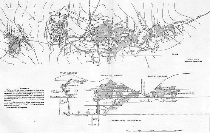
Workings include underground openings. Total development is reported at a length of 208,000 meters. The overall depth is 1,402 meters. The Kellogg Adit is 3,350 meters long and is the main mine access. Other sources estimate total workings at more than 240,000 meters. The Bunker Hill mine used several mining methods, including square sets, top slicing, room and pillar, and block caving.
Production statistics:
Year: 1983; period: 1887-1981: 35,457,348 metric tons of ore were mined. Major smelter recovery was Ag: 4,080 metric tons at 157 grams/ton.
Year: 1991; period: 1988-1991: 756,652 metric tons of ore were mined. Major commodity was Pb: in concentrate Pb 12,135 metric tons: 2 weight per cent.
Bunker Hill Mining Corp. (Toronto, Canada) has recently leased the historic workings in the hopes of exploiting previously unprofitable or undiscovered orebodies. Bunker Hill Mining Corp. is listed on the Canadian Securities Exchange under the symbol BNKR:CA (February 15th, 2021).
Leased and operated by the Helena Concentrating Co. (100.00%) (1885-1887);
Owned & operated by the Bunker Hill & Sullivan Mining & Concentrating Co. (100.00%), San Francisco, California (1887-1956);
Owned & operated by the Bunker Hill Co. (100.00%), Kellogg, Idaho (1956-1968);
Owned & operated by the Gulf Resources and Chemical Co. (100.00%) (1968-1982);
Owned & operated by the Bunker LP (100.00%), Spokane, Washington (1982);
Leased & operated by the Bunker Hill Mining Co. (U.S.) Inc. (100.00%), Kellogg, Idaho (1987–1994).
Stopes on the Jersey vein at Bunker Hill encountered oxidized lead-silver mineralization with abundant world-class pyromorphite crystals near their northern extent. Attempts were made to process this material through an oxide
circuit at the mill, but the attempts proved to be non-economic. The pyromorphite zone was mined for mineral specimens after the close of major mining operations. Fine pieces from this are undoubtably some of, if not the highest value-per-ton material that has ever been extracted at Bunker Hill, gracing cabinets at most prestigious mineral museums across the world
(according to minedocs.com; see below).
The modern Bunker Hill mine property is an amalgamation over time of many mines. Some of these mines, including the Caledonia, Last Chance, Sierra Nevada, and Senator Stewart, are described separately. They occupy positions peripheral to the main Bunker Hill orebodies and were largely mined out prior to incorporation with the Bunker Hill Mine.
Mineralization is a Neoproterozoic polymetallic deposit (Mineral occurrence model information: Model code 85; USGS model code 22c; deposit model name: polymetallic veins; Mark3 model number 46), hosted in Neoproterozoic quartzite of the St. Regis Formation and in Neoproterozoic quartzite of the Revett Formation.
Individual orebodies may be rich in galena (Pb) or sphalerite (Zn), with differing relative abundances of gangue and trace minerals. Local alteration includes sericitization, bleaching of hematite-bearing sediments, and chloritization.
Specifics pertaining to the individual orebodies:
— Emery orebody: pinch & swell; strike 52SE; dip 52SE; thickness: 478 meters; length: 267 meters.
— Francis orebody: pinch & swell; strike 58SE; dip 58SE; thickness: 537 meters; length: 212 meters.
— Guy orebody: tabular; strike 53SW; dip 53SW; thickness 117 meters; plunge 35; width: 91 meters; length: 305 meters.
— Hangingwall Tony orebody: tabular; strike: 29SW; dip: 29SW; width: 8 meters; length: 75 meters.
— Lower Tony orebody: pinch & swell; strike 25-30SE; dip 25-30SE; thickness: 300 meters; width: 9 meters; length: 120 meters.
— Mac orebody: pinch & swell; strike 35-40SE; dip 35-40SE; thickness: 600 meters; width: 2 meters; length: 370 meters.
— March orebody: wedge; strike 42SW; dip 42SW; thickness: 610 meters; width: 61 meters; length: 305 meters.
— Quill orebody: tabular; strike 42SW; dip 42SW; plunge: 34.
— Stanley orebody: tabular; strike 48SW; dip 48SW; thickness: 400 meters; length: 152 meters.
— Truman orebody: pinch & swell; strike 48SE; dip 48SE; thickness: 626 meters; length: 137 meters.
— Upper Tony orebody: tabular; strike 32SW; dip 32SW; thickness: 90 meters; width: 4.5 meters; length: 60 meters.
— West J orebody: pinch & swell; strike 35-45S; dip 35-45S; thickness: 366 meters; length: 427 meters.
There are dozens of orebodies in the deposit; only the larger ones are noted above.
Economic deposits are of two types:
(1) massive wedge-shaped or tabular open-space filling and replacement veins along faults and larger extension fractures striking NW to EW and dipping SW;
(2) Closely spaced fracture fillings near NE to EW striking SE or S dipping faults, forming pinch-and-swell veins (locally called Jersey or Link-type veins).
Sporadic stratiform mineralization throughout the mine is not economic. The largest orebody, the March, is a pipe-like triangular, prism-shaped replacement body at the intersection of the Cate and Dull faults.
The zone of disseminated siderite extends 10s to 100s of meters out from the veins, passing into a siderite-ankerite zone up to 10s of meters wide, and then into a zone of ankerite-calcite 100s of meters wide. The deposit is at least partly oxidized down to about 600 meters depth, presumably along major faults. Shallow orebodies mined in the 1880s to early 1900s were largely oxidized, with cerussite as the principal ore mineral.
Controls for ore emplacement:
Ore control descriptions: Orebodies occur mostly in the upper Revett Formation, consisting of about 50% massive quartzite interlayered with thin-bedded sericitic quartzite, siltite, and argillite.
Ore control descriptions in the NW part of the mine: Most ore is in the hanging wall of the Cate Fault, whereas, in the SE part, most ore is in the footwall of the Cate Fault.
Ore control descriptions: Structural controls are significant and of many varieties. Principal control is the intersection of two general fault and fracture sets (NW and NE) within the overturned northern limb of a WNW-trending anticline. Major replacement orebodies, such as the March, occur at the intersection of the Cate Fault with branching faults. NE striking Link veins are hosted by faults that connect the Cate with its various branch faults. Hinges of parasitic flexures on the anticlinal limb contain crackle zones that are an important control for the Quill and similar zinc orebodies.
Local rocks include argillite, siltite, and quartzite; Middle Proterozoic Ravalli Group; northern Belt Province.
Workings include underground openings. Total development is reported at a length of 208,000 meters. The overall depth is 1,402 meters. The Kellogg Adit is 3,350 meters long and is the main mine access. Other sources estimate total workings at more than 240,000 meters. The Bunker Hill mine used several mining methods, including square sets, top slicing, room and pillar, and block caving.
Production statistics:
Year: 1983; period: 1887-1981: 35,457,348 metric tons of ore were mined. Major smelter recovery was Ag: 4,080 metric tons at 157 grams/ton.
Year: 1991; period: 1988-1991: 756,652 metric tons of ore were mined. Major commodity was Pb: in concentrate Pb 12,135 metric tons: 2 weight per cent.
Bunker Hill Mining Corp. (Toronto, Canada) has recently leased the historic workings in the hopes of exploiting previously unprofitable or undiscovered orebodies. Bunker Hill Mining Corp. is listed on the Canadian Securities Exchange under the symbol BNKR:CA (February 15th, 2021).
Select Mineral List Type
Standard Detailed Gallery Strunz Chemical ElementsCommodity List
This is a list of exploitable or exploited mineral commodities recorded at this locality.Mineral List
32 valid minerals.
Rock Types Recorded
Select Rock List Type
Alphabetical List Tree DiagramDetailed Mineral List:
| ⓘ Acanthite Formula: Ag2S Habit: minute blade shaped crystals Colour: shiny black Description: found in the Orr orebody |
| ⓘ Anglesite Formula: PbSO4 Habit: blocky to tabular individual crystals in several habits to 5cm Colour: colorless, white, yellowish, smokey, nearly black |
| ⓘ Ankerite Formula: Ca(Fe2+,Mg)(CO3)2 |
| ⓘ Baryte Formula: BaSO4 |
| ⓘ Boulangerite Formula: Pb5Sb4S11 |
| ⓘ Bournonite Formula: PbCuSbS3 |
| ⓘ Calcite Formula: CaCO3 |
| ⓘ Caledonite Formula: Pb5Cu2(SO4)3(CO3)(OH)6 |
| ⓘ Cerussite Formula: PbCO3 |
| ⓘ Chalcopyrite Formula: CuFeS2 |
| ⓘ 'Chlorite Group' Description: Occurs as a product of local alteration. |
| ⓘ Covellite Formula: CuS |
| ⓘ Galena Formula: PbS |
| ⓘ Goethite Formula: Fe3+O(OH) |
| ⓘ Gypsum Formula: CaSO4 · 2H2O |
| ⓘ Hemimorphite Formula: Zn4Si2O7(OH)2 · H2O |
| ⓘ Hydrocerussite Formula: Pb3(CO3)2(OH)2 |
| ⓘ 'Limonite' Habit: earthy |
| ⓘ Linarite Formula: PbCu(SO4)(OH)2 |
| ⓘ Massicot Formula: PbO |
| ⓘ Muscovite Formula: KAl2(AlSi3O10)(OH)2 Description: Occurs as a product of local alteration. |
| ⓘ Muscovite var. Sericite Formula: KAl2(AlSi3O10)(OH)2 Description: Occurs as a product of local alteration. |
| ⓘ Native Copper Formula: Cu |
| ⓘ Native Silver Formula: Ag Description: Silver occurs on matrix with cerussite crystals. |
| ⓘ Plattnerite Formula: PbO2 |
| ⓘ Pyrargyrite Formula: Ag3SbS3 |
| ⓘ Pyrite Formula: FeS2 |
| ⓘ Pyrolusite Formula: Mn4+O2 |
| ✪ Pyromorphite Formula: Pb5(PO4)3Cl Description: Freilich Collection
Plate 58 from Wilson, Wendell. E.; Bartsch, Joel A.; Mauthner, Mark (2004) Masterpieces of the Mineral World. Houston Museum of Natural Science. [https://www.mindat.org/reference.php?id=18945017]
Beautiful cluster 8.7 cm year 1993/94 in Thompson, Wayne A. (2007, January) Ikons. References: |
| ⓘ Quartz Formula: SiO2 |
| ⓘ Siderite Formula: FeCO3 |
| ⓘ Smithsonite Formula: ZnCO3 References: |
| ⓘ Sphalerite Formula: ZnS |
| ⓘ Stephanite Formula: Ag5SbS4 |
| ⓘ 'Tetrahedrite Subgroup' Formula: Cu6(Cu4C2+2)Sb4S12S |
| ⓘ Wulfenite Formula: Pb(MoO4) |
Gallery:

List of minerals arranged by Strunz 10th Edition classification
| Group 1 - Elements | |||
|---|---|---|---|
| ⓘ | Native Copper | 1.AA.05 | Cu |
| ⓘ | Native Silver | 1.AA.05 | Ag |
| Group 2 - Sulphides and Sulfosalts | |||
| ⓘ | Acanthite | 2.BA.35 | Ag2S |
| ⓘ | Covellite | 2.CA.05a | CuS |
| ⓘ | Sphalerite | 2.CB.05a | ZnS |
| ⓘ | Chalcopyrite | 2.CB.10a | CuFeS2 |
| ⓘ | Galena | 2.CD.10 | PbS |
| ⓘ | Pyrite | 2.EB.05a | FeS2 |
| ⓘ | Pyrargyrite | 2.GA.05 | Ag3SbS3 |
| ⓘ | Bournonite | 2.GA.50 | PbCuSbS3 |
| ⓘ | 'Tetrahedrite Subgroup' | 2.GB.05 | Cu6(Cu4C2+2)Sb4S12S |
| ⓘ | Stephanite | 2.GB.10 | Ag5SbS4 |
| ⓘ | Boulangerite | 2.HC.15 | Pb5Sb4S11 |
| Group 4 - Oxides and Hydroxides | |||
| ⓘ | Goethite | 4.00. | Fe3+O(OH) |
| ⓘ | Massicot | 4.AC.25 | PbO |
| ⓘ | Quartz | 4.DA.05 | SiO2 |
| ⓘ | Plattnerite | 4.DB.05 | PbO2 |
| ⓘ | Pyrolusite | 4.DB.05 | Mn4+O2 |
| Group 5 - Nitrates and Carbonates | |||
| ⓘ | Calcite | 5.AB.05 | CaCO3 |
| ⓘ | Siderite | 5.AB.05 | FeCO3 |
| ⓘ | Smithsonite | 5.AB.05 | ZnCO3 |
| ⓘ | Ankerite | 5.AB.10 | Ca(Fe2+,Mg)(CO3)2 |
| ⓘ | Cerussite | 5.AB.15 | PbCO3 |
| ⓘ | Hydrocerussite | 5.BE.10 | Pb3(CO3)2(OH)2 |
| Group 7 - Sulphates, Chromates, Molybdates and Tungstates | |||
| ⓘ | Anglesite | 7.AD.35 | PbSO4 |
| ⓘ | Baryte | 7.AD.35 | BaSO4 |
| ⓘ | Caledonite | 7.BC.50 | Pb5Cu2(SO4)3(CO3)(OH)6 |
| ⓘ | Linarite | 7.BC.65 | PbCu(SO4)(OH)2 |
| ⓘ | Gypsum | 7.CD.40 | CaSO4 · 2H2O |
| ⓘ | Wulfenite | 7.GA.05 | Pb(MoO4) |
| Group 8 - Phosphates, Arsenates and Vanadates | |||
| ⓘ | Pyromorphite | 8.BN.05 | Pb5(PO4)3Cl |
| Group 9 - Silicates | |||
| ⓘ | Hemimorphite | 9.BD.10 | Zn4Si2O7(OH)2 · H2O |
| ⓘ | Muscovite | 9.EC.15 | KAl2(AlSi3O10)(OH)2 |
| ⓘ | var. Sericite | 9.EC.15 | KAl2(AlSi3O10)(OH)2 |
| Unclassified | |||
| ⓘ | 'Chlorite Group' | - | |
| ⓘ | 'Limonite' | - | |
List of minerals for each chemical element
| H | Hydrogen | |
|---|---|---|
| H | ⓘ Caledonite | Pb5Cu2(SO4)3(CO3)(OH)6 |
| H | ⓘ Goethite | Fe3+O(OH) |
| H | ⓘ Gypsum | CaSO4 · 2H2O |
| H | ⓘ Hemimorphite | Zn4Si2O7(OH)2 · H2O |
| H | ⓘ Hydrocerussite | Pb3(CO3)2(OH)2 |
| H | ⓘ Linarite | PbCu(SO4)(OH)2 |
| H | ⓘ Muscovite | KAl2(AlSi3O10)(OH)2 |
| H | ⓘ Muscovite var. Sericite | KAl2(AlSi3O10)(OH)2 |
| C | Carbon | |
| C | ⓘ Ankerite | Ca(Fe2+,Mg)(CO3)2 |
| C | ⓘ Calcite | CaCO3 |
| C | ⓘ Caledonite | Pb5Cu2(SO4)3(CO3)(OH)6 |
| C | ⓘ Cerussite | PbCO3 |
| C | ⓘ Hydrocerussite | Pb3(CO3)2(OH)2 |
| C | ⓘ Siderite | FeCO3 |
| C | ⓘ Smithsonite | ZnCO3 |
| O | Oxygen | |
| O | ⓘ Anglesite | PbSO4 |
| O | ⓘ Ankerite | Ca(Fe2+,Mg)(CO3)2 |
| O | ⓘ Baryte | BaSO4 |
| O | ⓘ Calcite | CaCO3 |
| O | ⓘ Caledonite | Pb5Cu2(SO4)3(CO3)(OH)6 |
| O | ⓘ Cerussite | PbCO3 |
| O | ⓘ Goethite | Fe3+O(OH) |
| O | ⓘ Gypsum | CaSO4 · 2H2O |
| O | ⓘ Hemimorphite | Zn4Si2O7(OH)2 · H2O |
| O | ⓘ Hydrocerussite | Pb3(CO3)2(OH)2 |
| O | ⓘ Linarite | PbCu(SO4)(OH)2 |
| O | ⓘ Massicot | PbO |
| O | ⓘ Muscovite | KAl2(AlSi3O10)(OH)2 |
| O | ⓘ Plattnerite | PbO2 |
| O | ⓘ Pyrolusite | Mn4+O2 |
| O | ⓘ Pyromorphite | Pb5(PO4)3Cl |
| O | ⓘ Quartz | SiO2 |
| O | ⓘ Siderite | FeCO3 |
| O | ⓘ Smithsonite | ZnCO3 |
| O | ⓘ Wulfenite | Pb(MoO4) |
| O | ⓘ Muscovite var. Sericite | KAl2(AlSi3O10)(OH)2 |
| Mg | Magnesium | |
| Mg | ⓘ Ankerite | Ca(Fe2+,Mg)(CO3)2 |
| Al | Aluminium | |
| Al | ⓘ Muscovite | KAl2(AlSi3O10)(OH)2 |
| Al | ⓘ Muscovite var. Sericite | KAl2(AlSi3O10)(OH)2 |
| Si | Silicon | |
| Si | ⓘ Hemimorphite | Zn4Si2O7(OH)2 · H2O |
| Si | ⓘ Muscovite | KAl2(AlSi3O10)(OH)2 |
| Si | ⓘ Quartz | SiO2 |
| Si | ⓘ Muscovite var. Sericite | KAl2(AlSi3O10)(OH)2 |
| P | Phosphorus | |
| P | ⓘ Pyromorphite | Pb5(PO4)3Cl |
| S | Sulfur | |
| S | ⓘ Acanthite | Ag2S |
| S | ⓘ Anglesite | PbSO4 |
| S | ⓘ Baryte | BaSO4 |
| S | ⓘ Boulangerite | Pb5Sb4S11 |
| S | ⓘ Bournonite | PbCuSbS3 |
| S | ⓘ Caledonite | Pb5Cu2(SO4)3(CO3)(OH)6 |
| S | ⓘ Chalcopyrite | CuFeS2 |
| S | ⓘ Covellite | CuS |
| S | ⓘ Galena | PbS |
| S | ⓘ Gypsum | CaSO4 · 2H2O |
| S | ⓘ Linarite | PbCu(SO4)(OH)2 |
| S | ⓘ Pyrargyrite | Ag3SbS3 |
| S | ⓘ Pyrite | FeS2 |
| S | ⓘ Sphalerite | ZnS |
| S | ⓘ Stephanite | Ag5SbS4 |
| S | ⓘ Tetrahedrite Subgroup | Cu6(Cu4C22+)Sb4S12S |
| Cl | Chlorine | |
| Cl | ⓘ Pyromorphite | Pb5(PO4)3Cl |
| K | Potassium | |
| K | ⓘ Muscovite | KAl2(AlSi3O10)(OH)2 |
| K | ⓘ Muscovite var. Sericite | KAl2(AlSi3O10)(OH)2 |
| Ca | Calcium | |
| Ca | ⓘ Ankerite | Ca(Fe2+,Mg)(CO3)2 |
| Ca | ⓘ Calcite | CaCO3 |
| Ca | ⓘ Gypsum | CaSO4 · 2H2O |
| Mn | Manganese | |
| Mn | ⓘ Pyrolusite | Mn4+O2 |
| Fe | Iron | |
| Fe | ⓘ Ankerite | Ca(Fe2+,Mg)(CO3)2 |
| Fe | ⓘ Chalcopyrite | CuFeS2 |
| Fe | ⓘ Goethite | Fe3+O(OH) |
| Fe | ⓘ Pyrite | FeS2 |
| Fe | ⓘ Siderite | FeCO3 |
| Cu | Copper | |
| Cu | ⓘ Bournonite | PbCuSbS3 |
| Cu | ⓘ Caledonite | Pb5Cu2(SO4)3(CO3)(OH)6 |
| Cu | ⓘ Chalcopyrite | CuFeS2 |
| Cu | ⓘ Covellite | CuS |
| Cu | ⓘ Native Copper | Cu |
| Cu | ⓘ Linarite | PbCu(SO4)(OH)2 |
| Cu | ⓘ Tetrahedrite Subgroup | Cu6(Cu4C22+)Sb4S12S |
| Zn | Zinc | |
| Zn | ⓘ Hemimorphite | Zn4Si2O7(OH)2 · H2O |
| Zn | ⓘ Smithsonite | ZnCO3 |
| Zn | ⓘ Sphalerite | ZnS |
| Mo | Molybdenum | |
| Mo | ⓘ Wulfenite | Pb(MoO4) |
| Ag | Silver | |
| Ag | ⓘ Acanthite | Ag2S |
| Ag | ⓘ Pyrargyrite | Ag3SbS3 |
| Ag | ⓘ Native Silver | Ag |
| Ag | ⓘ Stephanite | Ag5SbS4 |
| Sb | Antimony | |
| Sb | ⓘ Boulangerite | Pb5Sb4S11 |
| Sb | ⓘ Bournonite | PbCuSbS3 |
| Sb | ⓘ Pyrargyrite | Ag3SbS3 |
| Sb | ⓘ Stephanite | Ag5SbS4 |
| Sb | ⓘ Tetrahedrite Subgroup | Cu6(Cu4C22+)Sb4S12S |
| Ba | Barium | |
| Ba | ⓘ Baryte | BaSO4 |
| Pb | Lead | |
| Pb | ⓘ Anglesite | PbSO4 |
| Pb | ⓘ Boulangerite | Pb5Sb4S11 |
| Pb | ⓘ Bournonite | PbCuSbS3 |
| Pb | ⓘ Caledonite | Pb5Cu2(SO4)3(CO3)(OH)6 |
| Pb | ⓘ Cerussite | PbCO3 |
| Pb | ⓘ Galena | PbS |
| Pb | ⓘ Hydrocerussite | Pb3(CO3)2(OH)2 |
| Pb | ⓘ Linarite | PbCu(SO4)(OH)2 |
| Pb | ⓘ Massicot | PbO |
| Pb | ⓘ Plattnerite | PbO2 |
| Pb | ⓘ Pyromorphite | Pb5(PO4)3Cl |
| Pb | ⓘ Wulfenite | Pb(MoO4) |
Other Databases
| Wikipedia: | https://en.wikipedia.org/wiki/Bunker_Hill_Mine_and_Smelting_Complex |
|---|---|
| Wikidata ID: | Q4997766 |
| Link to USGS MRDS: | 10105938 |
Other Regions, Features and Areas containing this locality
North AmericaContinent
North America PlateTectonic Plate
- Antler Foreland BasinBasin
- Belt BasinBasin
- Pend Oreille DomainDomain
- West Canadian-Alberta basinBasin
USA
- Idaho
- Coeur d'Alene Mining DistrictMining District
- Yreka Mining DistrictMining District
- Montana
This page contains all mineral locality references listed on mindat.org. This does not claim to be a complete list. If you know of more minerals from this site, please register so you can add to our database. This locality information is for reference purposes only. You should never attempt to
visit any sites listed in mindat.org without first ensuring that you have the permission of the land and/or mineral rights holders
for access and that you are aware of all safety precautions necessary.
References
Ransome, F. L.; Calkins, Frank Cathcart (1908) The geology and ore deposits of the Coeur d'Alene district, Idaho. Professional Paper 62. US Geological Survey 203 pp. doi:10.3133/pp62
Rolland R. Reid (1961) Guidebook to the Geology of the Coeur d'Alene Mining District. Bulletin 16. Idaho Bureau of Mines and Geology
Fryklund, Verne Charles; Weis, Paul L. (1964) Ore deposits of the Coeur d'Alene district, Shoshone County, Idaho, with a section on the bleached rock in the Coeur d'Alene district. Professional Paper 445. US Geological Survey 103 pp. doi:10.3133/pp445
Zartman, Robert E., Stacey, John S. (1971) Lead isotopes and mineralization ages in Belt supergroup rocks, northwestern Montana and northern Idaho. Economic Geology, 66 (6) 849-860 doi:10.2113/gsecongeo.66.6.849
Ream, Lanny R. (1995) Idaho: Mineral Locality Index. Rocks & Minerals, 70 (4) 242-263 doi:10.1080/00357529.1995.9926628
Fredrickson, Leif (2018) Leaded: The Poisoning of Idaho’s Silver Valley. By Michael C. Mix. Environmental History, 23 (1). 213-215 doi:10.1093/envhis/emx100

Bunker Hill Mine, Wardner, Shoshone County, Idaho, USA