
French Corral Mining District, Nevada County, California, USAi
| Regional Level Types | |
|---|---|
| French Corral Mining District | Mining District |
| Nevada County | County |
| California | State |
| USA | Country |
This page is currently not sponsored. Click here to sponsor this page.
Latitude & Longitude (WGS84):
39° 18' 13'' North , 121° 9' 8'' West
Latitude & Longitude (decimal):
Type:
Köppen climate type:
Location: A former Au-Ag-Pt-diamond mining area discovered in 1850, French Corral is in northwestern Nevada County about nine miles NW of Nevada City in secs. 13, 14 and 23 to 26, T17N, R7E, MDM. Much of the gold production came from hydraulic mines between here and Birchville to the NE. The location selected for latitude and longitude by the USGS is the approximate center of the French Corral placer workings on the USGS 7 1/2-minute French Corral quadrangle.
History: The mining camp of French Corral was the first of many to be established in the rich placer deposits flanking San Juan Ridge. The town was named for a mule corral erected by a Frenchman, who was the first settler in the area. The principal period of gold mining was from the middle 1850's to the 1890's; there has been minor work since. Sometime before 1867, a 7¼ carat diamond, the largest known to have come from California, was found here in a sluice box.
French Corral was the first historic mining camp to be established along San Juan Ridge. The camp was named for a mule corral built by the area's first settler in 1849. The principle period of mining occurred from 1850 to the mid-1880s with small-scale placer mining operations and extensive hydraulic mining operations, which were implemented in the mid-1850s. In 1884, the Sawyer Decision curtailed hydraulic mining throughout the northern Sierra Nevada. By that time approximately half of the gravel deposits present had been hydraulically mined. After the hydraulic mines shut down, only small-scale placer mining operations continued.
During its heyday, French Corral became an important mining center, second only to North San Juan in size and importance.
Because of the extensive hydraulic mining operations at French Corral, nearby North Bloomfield, and many other hydraulic mines along San Juan Ridge, the three leading mining companies (North Bloomfield Gravel Mining Co., Milton Mining and Water Co., and Eureka Lake and Yuba Canal Co.) spent over $5 million (period values) constructing an extensive 320-mile system of ditches, flumes, and reservoirs to bring water to the mines from Bowman Lake and other sources in the High Sierra. In order to manage the water deliveries, in 1878 the Edison Company built the world's first long distance telephone line at a cost of $6,000. French Corral was the end of the line, which ran 60 miles through the other important mining areas of Birchville, North San Juan, Cherokee, North Columbia, Lake City, North Bloomfield, Moore's Flat, Graniteville, and Milton to Bowman Lake.
Minor work was conducted on the deposits between the 1960s and 1980s. In the early 1960s, several small lessors were known to have been conducing some operations. Generally these were small-scale open-pit operations involving a bulldozer, dragline, washing plant, trommel, and sluices.
From the 1970s through mid 1980s, the Pantle Mining Company mined approximately 50 acres of the deposits under contract for the landowner. Little is known of these open-pit operations.
In 1989, the same ground worked earlier by the Pantle Mining Company was reworked by the French Corral Corp. The company operated a 6-inch vibrating grizzly, rotating scrubber, vibrating screen and shaker table to process the gravels. Recovered gold consisted of small, flattened gold nuggets from 0.5 to 1.0 mm in diameter.
Little remains of French Corral today. The Wells Fargo building, considered one of the premier gold-rush era structures still stands. The site of the Milton Mining and Water Company office in which the long distance telephone was installed is marked by a plaque.
French Corral was the terminus of one of the first long-distance telephone lines in the United States. Installed by the Edison Company about 1878, it connected Birchville, North San Juan and North Bloomfield
to Bowman or French Lake, in the high Sierra Nevada some 58 miles east. It was used primarily to send messages about the delivery of water to the hydraulic mines, but it also was used by Western Union to send other messages.
Mineralogy: Mineral occurrence model information: Model code: 119; USGS model code: 39a; BC deposit profile: C01. C02; Deposit model name: Placer Au-PGE; Mark3 model number: 54. The ore bodies are irregular in form. Mineralization is placer Au deposits hosted in Tertiary sand & gravels. Local rocks include Mesozoic granitic rocks, unit 3 (Sierra Nevada, Death Valley area, Northern Mojave Desert and Transverse Ranges).
Geology: Regional and local geologic structures include
the Big Bend-Wolf Creek Fault Zone.
A major channel of the Tertiary Yuba River entered the area from the northeast. It extends SW for a distance of about four miles in this district. The gravels deposited by this channel are 150 to 250 feet thick and 600 or more feet wide. The gravels have yielded gold throughout, but the quartz-rich lower gravels were the richest. Bedrock is granodiorite with greenstone to the N. Also there are some gold-quartz veins and bodies of mineralized granodiorite and greenstone.
In the French Corral District, basement rocks consist of metavolcanic rocks, quartz diorite, granodiorite, greenstone, and gabbroic rocks of the Jurassic Smartville Complex, with granodiorite and greenstone prevailing. The district lies along the eastern edge of the Western Belt of the Sierra Nevada basement complex. The Big Bend-Wolf Creek fault zone marks the eastern edge of the district and separates the Smartville Complex bedrock from granites and gabbroic rocks of the Central Belt.
The district is one of the westernmost of the Tertiary gravel mining districts in the northern Sierra Nevada. Unlike many of its counterparts farther east, rocks of the Oligocene to Pliocene Valley Springs and Mehrten formations have been completely eroded away and the auriferous gravels are directly exposed resting on bedrock.
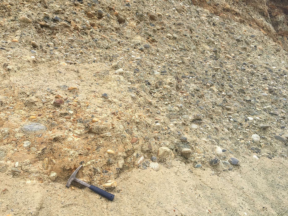
Basal Eocene Auriferous Gravels: The French Corral deposits comprise a sinuous band of auriferous gravels preserved in the valley of French Corral Creek. The deposits extend approximately 2.5 miles along the creek from the community of French Corral to Birchville on the north. The deposits are generally narrow and thin by comparison with many other Tertiary gravel mining districts, being generally no wider than 1,500 feet and between 150 and 250 feet thick.
The gravels were deposited by a southwesterly flowing main branch of the ancestral Yuba River. This branch flowed southwestward from the North San Juan District (2-3 miles north), through the French Corral District and continued its southwesterly course to the Smartsville District 10 miles to the southwest.
While the deposits display both a lower coarse gravel unit and a finer upper unit, most of the gravels belong to the lower unit due to extensive erosion and thinning of the upper gravel unit. The basal gravels, or blue lead of the early miners, are the richest. They are generally more cemented than the upper gravels, immature, and composed of darker clasts stripped from the upstream bedrock lithologies including bluish slate, gabbroic rocks, and serpentinite. Accessory minerals include zircon, garnet, magnetite, pyrite, and diamonds. Extremely large boulders were also encountered in the bedrock channel. Descriptions from later operations described these boulders as the size of a pickup truck. Lower gravels averaged $0.70 per cubic yard (@ $35 gold).
The upper gravels are much finer, with clasts seldom larger than pebble size and characterized by an abundance of quartz sand and clay and silt beds. Large-scale cross-bedding and cut-and-fill features are common. Upper gravels carried significantly lower values than the deeper gravels. Upper gravels yielded an average $0.24 per cubic yard (@ $35 gold).
Production Data: The total production of the district is unknown, but it has been estimated to be valued at between $3 million and $4 million (period values). Lindgren, in 1911, estimated that 32.5 million cubic yards of gravel had been removed and that 20 million remained; the U.S. Army Corps of Engineers, in 1891, estimated that the same amount had been removed, but that only 10 million yards remained.
Select Mineral List Type
Standard Detailed Gallery Strunz Chemical ElementsMineral List
Mineral list contains entries from the region specified including sub-localities10 valid minerals.
Detailed Mineral List:
| ⓘ 'Amphibole Supergroup' Formula: AB2C5((Si,Al,Ti)8O22)(OH,F,Cl,O)2 |
| ⓘ 'Chlorite Group' |
| ⓘ Diamond Formula: C Description: Largest diamond from the state was found here at 7¼ carets. Found sometime before 1867. References: |
| ⓘ Epidote Formula: (CaCa)(AlAlFe3+)O[Si2O7][SiO4](OH) |
| ⓘ 'Garnet Group' Formula: X3Z2(SiO4)3 |
| ⓘ Ilmenite Formula: Fe2+TiO3 |
| ⓘ Magnetite Formula: Fe2+Fe3+2O4 |
| ⓘ Native Copper Formula: Cu |
| ⓘ Native Gold Formula: Au Localities: Reported from at least 12 localities in this region. |
| ⓘ Pyrite Formula: FeS2 Localities: French Corral Mining District, Nevada County, California, USA French Corral placers (French Corral Diggings), French Corral, French Corral Mining District, Nevada County, California, USA Red Ledge Consolidated Mine (South Yuba Mine; So. Yuba; Red Ledge Cons.), French Corral, French Corral Mining District, Nevada County, California, USA |
| ⓘ Quartz Formula: SiO2 |
| ⓘ Siderite Formula: FeCO3 |
| ⓘ Zircon Formula: Zr(SiO4) |
Gallery:
List of minerals arranged by Strunz 10th Edition classification
| Group 1 - Elements | |||
|---|---|---|---|
| ⓘ | Native Copper | 1.AA.05 | Cu |
| ⓘ | Native Gold | 1.AA.05 | Au |
| ⓘ | Diamond | 1.CB.10a | C |
| Group 2 - Sulphides and Sulfosalts | |||
| ⓘ | Pyrite | 2.EB.05a | FeS2 |
| Group 4 - Oxides and Hydroxides | |||
| ⓘ | Magnetite | 4.BB.05 | Fe2+Fe3+2O4 |
| ⓘ | Ilmenite | 4.CB.05 | Fe2+TiO3 |
| ⓘ | Quartz | 4.DA.05 | SiO2 |
| Group 5 - Nitrates and Carbonates | |||
| ⓘ | Siderite | 5.AB.05 | FeCO3 |
| Group 9 - Silicates | |||
| ⓘ | Zircon | 9.AD.30 | Zr(SiO4) |
| ⓘ | Epidote | 9.BG.05a | (CaCa)(AlAlFe3+)O[Si2O7][SiO4](OH) |
| Unclassified | |||
| ⓘ | 'Amphibole Supergroup' | - | AB2C5((Si,Al,Ti)8O22)(OH,F,Cl,O)2 |
| ⓘ | 'Chlorite Group' | - | |
| ⓘ | 'Garnet Group' | - | X3Z2(SiO4)3 |
List of minerals for each chemical element
| H | Hydrogen | |
|---|---|---|
| H | ⓘ Amphibole Supergroup | AB2C5((Si,Al,Ti)8O22)(OH,F,Cl,O)2 |
| H | ⓘ Epidote | (CaCa)(AlAlFe3+)O[Si2O7][SiO4](OH) |
| C | Carbon | |
| C | ⓘ Diamond | C |
| C | ⓘ Siderite | FeCO3 |
| O | Oxygen | |
| O | ⓘ Amphibole Supergroup | AB2C5((Si,Al,Ti)8O22)(OH,F,Cl,O)2 |
| O | ⓘ Epidote | (CaCa)(AlAlFe3+)O[Si2O7][SiO4](OH) |
| O | ⓘ Ilmenite | Fe2+TiO3 |
| O | ⓘ Magnetite | Fe2+Fe23+O4 |
| O | ⓘ Quartz | SiO2 |
| O | ⓘ Siderite | FeCO3 |
| O | ⓘ Zircon | Zr(SiO4) |
| O | ⓘ Garnet Group | X3Z2(SiO4)3 |
| F | Fluorine | |
| F | ⓘ Amphibole Supergroup | AB2C5((Si,Al,Ti)8O22)(OH,F,Cl,O)2 |
| Al | Aluminium | |
| Al | ⓘ Amphibole Supergroup | AB2C5((Si,Al,Ti)8O22)(OH,F,Cl,O)2 |
| Al | ⓘ Epidote | (CaCa)(AlAlFe3+)O[Si2O7][SiO4](OH) |
| Si | Silicon | |
| Si | ⓘ Amphibole Supergroup | AB2C5((Si,Al,Ti)8O22)(OH,F,Cl,O)2 |
| Si | ⓘ Epidote | (CaCa)(AlAlFe3+)O[Si2O7][SiO4](OH) |
| Si | ⓘ Quartz | SiO2 |
| Si | ⓘ Zircon | Zr(SiO4) |
| Si | ⓘ Garnet Group | X3Z2(SiO4)3 |
| S | Sulfur | |
| S | ⓘ Pyrite | FeS2 |
| Cl | Chlorine | |
| Cl | ⓘ Amphibole Supergroup | AB2C5((Si,Al,Ti)8O22)(OH,F,Cl,O)2 |
| Ca | Calcium | |
| Ca | ⓘ Epidote | (CaCa)(AlAlFe3+)O[Si2O7][SiO4](OH) |
| Ti | Titanium | |
| Ti | ⓘ Amphibole Supergroup | AB2C5((Si,Al,Ti)8O22)(OH,F,Cl,O)2 |
| Ti | ⓘ Ilmenite | Fe2+TiO3 |
| Fe | Iron | |
| Fe | ⓘ Epidote | (CaCa)(AlAlFe3+)O[Si2O7][SiO4](OH) |
| Fe | ⓘ Ilmenite | Fe2+TiO3 |
| Fe | ⓘ Magnetite | Fe2+Fe23+O4 |
| Fe | ⓘ Pyrite | FeS2 |
| Fe | ⓘ Siderite | FeCO3 |
| Cu | Copper | |
| Cu | ⓘ Native Copper | Cu |
| Zr | Zirconium | |
| Zr | ⓘ Zircon | Zr(SiO4) |
| Au | Gold | |
| Au | ⓘ Native Gold | Au |
Other Databases
| Link to USGS MRDS: | 10310616 |
|---|
Localities in this Region
- California
- Nevada County
- French Corral Mining District
- Nevada County
- California
- Nevada County
- French Corral Mining District
- French Corral
- Empire Consolidated Placer prospect (Empire Cons.)
- Esperance Placer Mine
- French Bar Placer Mine
- French Corral placers (French Corral Diggings)
- Gold Reserve Mine
- Kentucky Creek Placer Mine
- Minona Placer Mine
- Red Ledge Consolidated Mine (South Yuba Mine; So. Yuba; Red Ledge Cons.)
- Slide Quartz Mine
- Unnamed Au placer [1] (Auriferous gravels)
- French Corral
- French Corral Mining District
- Nevada County
Other Regions, Features and Areas containing this locality
North AmericaContinent
North America PlateTectonic Plate
- Foothills-Wallowa DomainDomain
- Sierra Nevada BatholithVolcanic Arc
USA
- Sierra NevadaMountain Range
This page contains all mineral locality references listed on mindat.org. This does not claim to be a complete list. If you know of more minerals from this site, please register so you can add to our database. This locality information is for reference purposes only. You should never attempt to
visit any sites listed in mindat.org without first ensuring that you have the permission of the land and/or mineral rights holders
for access and that you are aware of all safety precautions necessary.
References

French Corral, French Corral Mining District, Nevada County, California, USA