
Anstey Hill Recreation Park, City of Tea Tree Gully, South Australia, Australiai
| Regional Level Types | |
|---|---|
| Anstey Hill Recreation Park | Park |
| City of Tea Tree Gully | Local Government Area |
| South Australia | State |
| Australia | Country |
This page is currently not sponsored. Click here to sponsor this page.


Neighbouring regions:
Type:
Anstey Hill Recreation Park
Fossicking and collecting at this site is now prohibited.
*Notes from Department for Environment and Heritage Brochure*
Divided by a number of short creeks and steep gullies, Anstey Hill recreation Park forms an attractive backdrop to the Adelaide suburbs. Located eighteen kilometres north-east of Adelaide, Anstey Hill Recreation Park, a reserve of 383 ha, was dedicated in September 1989 in response to public demand that the government protect the land from development.
Today, the park conserves some of the last remaining vegetation associations that were once widespread throughout the Adelaide Plains and Mount Lofty Ranges. Evidence of early settlement of the district can be found in the ruins and quarries in the park. There are excellent opportunities for bushwalking, birdwatching, photography, painting, heritage and nature study.
The geological formations and rock types we see at Anstey Hill today began 1000 million years ago.
A semi-circular level area of land named ‘The Gun Emplacement’ because of its resemblansce is the remnant of an ancient land surface which existed
about 40 million years ago, before the Mount Lofty Ranges were formed. It is a unique geological feature of outstanding aesthetic, educational and
recreational value, which has been designated as a geological monument.
A silver mine and several quarries are scattered throughout the park. Materials from these quarries have been used in the construction of roads
throughout Tea Tree Gully.
The quarries also supplied stone for the Adelaide War Memorial on North Terrace, Adelaide Town Hall, St Peters Cathedral and the Adelaide General Post Office.
The last quarry closed in 1982.
The National Parks Code
Help protect your national parks by following these guidelines:
• dogs are permitted in the park, but must be kept on a lead at all times
• take your rubbish with you
• all fires including gas barbecues are prohibited
• respect geological or heritage sites
• keep our wildlife wild – do not feed or disturb animals, or remove native plants
• keep to defined vehicle tracks and walking trails
• bike riding is prohibited within this reserve
• be considerate of other park users.
Select Mineral List Type
Standard Detailed Gallery Strunz Chemical ElementsCommodity List
This is a list of exploitable or exploited mineral commodities recorded from this region.Mineral List
Mineral list contains entries from the region specified including sub-localities6 valid minerals.
Rock Types Recorded
Note: data is currently VERY limited. Please bear with us while we work towards adding this information!
Rock list contains entries from the region specified including sub-localities
Select Rock List Type
Alphabetical List Tree DiagramDetailed Mineral List:
| ⓘ Atacamite Formula: Cu2(OH)3Cl |
| ⓘ Dolomite Formula: CaMg(CO3)2 Localities: Highways Department West (Local Government Quarry), Anstey Hill Recreation Park, City of Tea Tree Gully, South Australia, Australia Highways Department East (Local Government Quarry), Anstey Hill Recreation Park, City of Tea Tree Gully, South Australia, Australia Tea Tree Gully Mine (Tea Tree Iron Mine; Tea Tree Silver Mine; Ironstone Quarry), Anstey Hill Recreation Park, City of Tea Tree Gully, South Australia, Australia |
| ⓘ Huntite Formula: CaMg3(CO3)4 |
| ⓘ Native Gold Formula: Au References: |
| ⓘ Pyrite Formula: FeS2 |
| ⓘ Quartz Formula: SiO2 Localities: Reported from at least 6 localities in this region. |

List of minerals arranged by Strunz 10th Edition classification
| Group 1 - Elements | |||
|---|---|---|---|
| ⓘ | Native Gold | 1.AA.05 | Au |
| Group 2 - Sulphides and Sulfosalts | |||
| ⓘ | Pyrite | 2.EB.05a | FeS2 |
| Group 3 - Halides | |||
| ⓘ | Atacamite | 3.DA.10a | Cu2(OH)3Cl |
| Group 4 - Oxides and Hydroxides | |||
| ⓘ | Quartz | 4.DA.05 | SiO2 |
| Group 5 - Nitrates and Carbonates | |||
| ⓘ | Dolomite | 5.AB.10 | CaMg(CO3)2 |
| ⓘ | Huntite | 5.AB.25 | CaMg3(CO3)4 |
List of minerals for each chemical element
| H | Hydrogen | |
|---|---|---|
| H | ⓘ Atacamite | Cu2(OH)3Cl |
| C | Carbon | |
| C | ⓘ Dolomite | CaMg(CO3)2 |
| C | ⓘ Huntite | CaMg3(CO3)4 |
| O | Oxygen | |
| O | ⓘ Atacamite | Cu2(OH)3Cl |
| O | ⓘ Dolomite | CaMg(CO3)2 |
| O | ⓘ Huntite | CaMg3(CO3)4 |
| O | ⓘ Quartz | SiO2 |
| Mg | Magnesium | |
| Mg | ⓘ Dolomite | CaMg(CO3)2 |
| Mg | ⓘ Huntite | CaMg3(CO3)4 |
| Si | Silicon | |
| Si | ⓘ Quartz | SiO2 |
| S | Sulfur | |
| S | ⓘ Pyrite | FeS2 |
| Cl | Chlorine | |
| Cl | ⓘ Atacamite | Cu2(OH)3Cl |
| Ca | Calcium | |
| Ca | ⓘ Dolomite | CaMg(CO3)2 |
| Ca | ⓘ Huntite | CaMg3(CO3)4 |
| Fe | Iron | |
| Fe | ⓘ Pyrite | FeS2 |
| Cu | Copper | |
| Cu | ⓘ Atacamite | Cu2(OH)3Cl |
| Au | Gold | |
| Au | ⓘ Native Gold | Au |
Fossils
This region is too big or complex to display the fossil list, try looking at smaller subregions.Localities in this Region
- South Australia
- City of Tea Tree Gully
- Anstey Hill Recreation Park
- ⭔Highways Department East (Local Government Quarry)
- ⭔Highways Department West (Local Government Quarry)
- Kloppers Quarry (Highercobme District Council Quarry; Coulls Quarry; Anstey Hill Quarry; Hills Quarry)
- Tea Tree Gully Mine (Tea Tree Iron Mine; Tea Tree Silver Mine; Ironstone Quarry)
- Tea Tree Gully Quarry (PM 92; Quarry Industries)
- Tea Tree Gully Sandstone Quarries (Bundey's Quarry; G. Hannaford's Quarry; Roadside Quarry; Saint Peter's Quarry; Tea Tree Gully DC Quarry; Torode's Quarry; Glen Ewin Quarry; Brown and Thompson's)
- Anstey Hill Recreation Park
- City of Tea Tree Gully
Other Regions, Features and Areas that Intersect
Australia
- Adelaide SuperbasinBasin
- Delamerian OrogenOrogen
- South Australia
- Mount Lofty RangesMountain Range
- South Mount Lofty Ranges (Adelaide Hills)Mountain Range
Australian PlateTectonic Plate
This page contains all mineral locality references listed on mindat.org. This does not claim to be a complete list. If you know of more minerals from this site, please register so you can add to our database. This locality information is for reference purposes only. You should never attempt to
visit any sites listed in mindat.org without first ensuring that you have the permission of the land and/or mineral rights holders
for access and that you are aware of all safety precautions necessary.

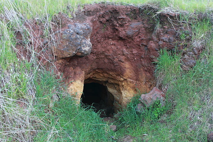
Tea Tree Gully Mine, Anstey Hill Recreation Park, City of Tea Tree Gully, South Australia, Australia