
Newton Mine (Newton Copper Mine; Jackson Mine), Sunnybrook, Pardee Mining District, Amador County, California, USAi
| Regional Level Types | |
|---|---|
| Newton Mine (Newton Copper Mine; Jackson Mine) | Mine |
| Sunnybrook | Residential Area |
| Pardee Mining District | Mining District |
| Amador County | County |
| California | State |
| USA | Country |
This page is currently not sponsored. Click here to sponsor this page.
Latitude & Longitude (WGS84):
38° 20' 31'' North , 120° 53' 8'' West
Latitude & Longitude (decimal):
Type:
Köppen climate type:
Nearest Settlements:
| Place | Population | Distance |
|---|---|---|
| Ione | 7,000 (2017) | 4.3km |
| Buena Vista | 429 (2011) | 5.8km |
| Martell | 282 (2011) | 8.3km |
| Sutter Creek | 2,488 (2017) | 9.2km |
| Jackson | 4,649 (2017) | 9.7km |
Nearest Clubs:
Local clubs are the best way to get access to collecting localities
Local clubs are the best way to get access to collecting localities
| Club | Location | Distance |
|---|---|---|
| Amador County Gem & Mineral Society | Sutter Creek, California | 9km |
| Calaveras Gem & Mineral Society | Angels Camp, California | 43km |
| El Dorado County Mineral and Gem Society | Placerville, California | 44km |
| Gold Country Treasure Seekers | Placerville, California | 44km |
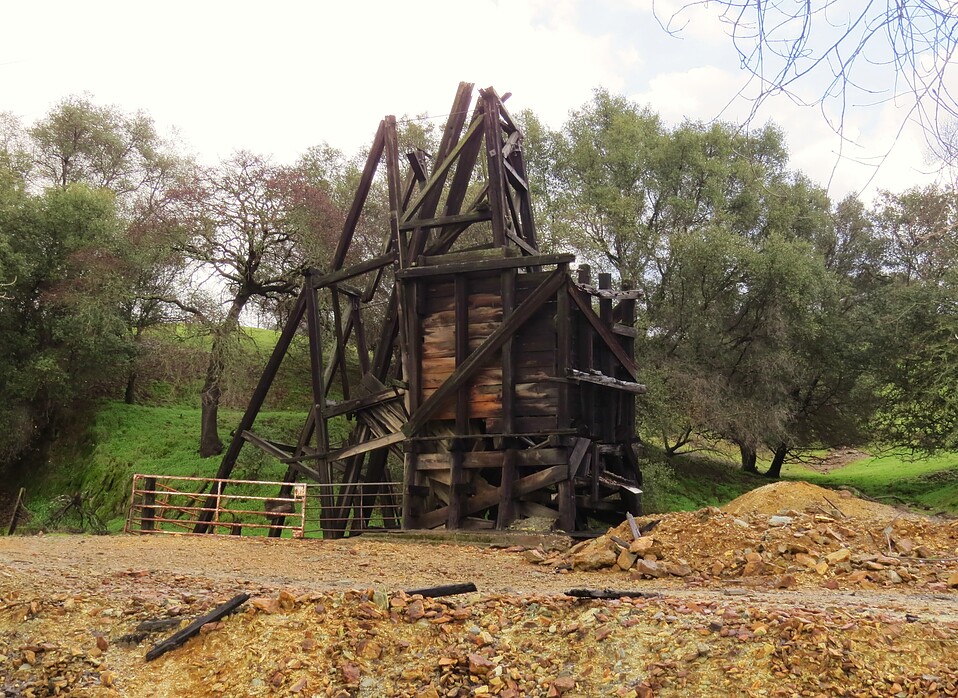
A former large lode Cu-Au-Ag-Pb-Zn mine located in the SW¼ sec. 28, T6N, R10E, MDM, 0.8 km (0.5 mile) W of Sunnybrook, on the S side of highway 88 and about 3 miles NE of Ione, about 6 miles W of Jackson, on patented (private) land. Discovered in 1863. Owned by the Dufrene estate and J. H. Lester; Utah Construction Co. (timeframes unknown). Operated during the period 1863 to 1946. Mine was idled between 1909 and 1942. MRDS database stated accuracy for this location is 100 meters.
Mineralization is a polymetallic deposit (Mineral occurrence model information: Model code: 184; USGS model code: 28a; Deposit model name: Massive sulfide, kuroko; Mark3 model number: 93), hosted in greenstone & schist. The ore body is lenticular in form, strikes N40W and dips 70NE at a thickness of 2.44 meters, a plunge of 62-65, and a length of 140.21 meters. Its maximum strike length is 460 feet. It has been mined through a length down-dip of about 600 feet. Drilling has proven that the ore extends more than 800 feet down-dip from the surface. It rakes northward with a pitch angle close to 77 degrees and a pitch length of about 900 feet. Controls for ore emplacement included a zone of structual disturbance found where East-dipping foliation lies adjacent to West-dipping foliation. This zone extends through the Newton Mine. Due to the lack of lithologic correlation across the strike, this zone is more suggestive of a fault along the axial plane of an isoclinal fold than a zone of stretching and displacement in an overturned limb of a major anticline.
A thick series of schists and greenstone of low-grade metamorphism occur. Graded bedding was observed on rocks and dips steeply E. Capping higher, neighboring sand, dipping W with no evidence of deformation. This sequence lies unconformably over older rocks. Local rocks include Jurassic marine rocks, unit 1 (Western Sierra Nevada and Western Klamath Mountains).
Local geologic structures include folds having amplitudes and wave lengths ranging from 1 to 10 feet. A system of cross-faults show apparent strike-slip displacements of 20 feet. These faults displace the ore body. Slickensides were observed with a low pitch. There is one post-ore reverse fault on the 200 foot level that dips 55-60W, net slip parallel to the dip.
Workings include underground openings with an overall depth of 167.64 meters. Workings are extensive. During the period 1942 to 1943 the U.S. Bureau of mines put down 5 diamond drill holes totaling 4,258 feet. Hole No. 1 intersected the 400 foot level of the mine; No. 2 encountered ore; Nos. 3 & 5 showed ore at depth; and, No. 4 failed to intersect ore N of the main ore body. Good indications were provided that the bottom of the sulfide lens lies considerably below the 550 foot level of the mine.
Production data are found in: Heyl, George Richard and Eric, J.H. (1948).
Some Zn was produced but production wasn't recorded.
The ore ranges in grade from 1.25% to 21% Cu, a little Zn & Pb, Au & Ag.
Select Mineral List Type
Standard Detailed Gallery Strunz Chemical ElementsCommodity List
This is a list of exploitable or exploited mineral commodities recorded at this locality.Mineral List
12 valid minerals.
Detailed Mineral List:
| ⓘ 'Anauxite' |
| ⓘ Calcite Formula: CaCO3 |
| ⓘ Chalcocite Formula: Cu2S Description: Occurs in appreciable amounts in the deepest levels of the mine. |
| ⓘ Chalcopyrite Formula: CuFeS2 Description: Chief ore mineral here. References: |
| ⓘ Copiapite Formula: Fe2+Fe3+4(SO4)6(OH)2 · 20H2O |
| ⓘ Cuprocopiapite Formula: Cu2+Fe3+4(SO4)6(OH)2 · 20H2O |
| ⓘ Galena Formula: PbS |
| ⓘ Kornelite Formula: Fe2(SO4)3 · 7H2O |
| ⓘ Muscovite Formula: KAl2(AlSi3O10)(OH)2 |
| ⓘ Muscovite var. Sericite Formula: KAl2(AlSi3O10)(OH)2 |
| ⓘ Native Copper Formula: Cu Description: Occurs as arborescent masses. |
| ⓘ Pyrite Formula: FeS2 |
| ⓘ Quartz Formula: SiO2 |
| ⓘ Sphalerite Formula: ZnS |
Gallery:
List of minerals arranged by Strunz 10th Edition classification
| Group 1 - Elements | |||
|---|---|---|---|
| ⓘ | Native Copper | 1.AA.05 | Cu |
| Group 2 - Sulphides and Sulfosalts | |||
| ⓘ | Chalcocite | 2.BA.05 | Cu2S |
| ⓘ | Sphalerite | 2.CB.05a | ZnS |
| ⓘ | Chalcopyrite | 2.CB.10a | CuFeS2 |
| ⓘ | Galena | 2.CD.10 | PbS |
| ⓘ | Pyrite | 2.EB.05a | FeS2 |
| Group 4 - Oxides and Hydroxides | |||
| ⓘ | Quartz | 4.DA.05 | SiO2 |
| Group 5 - Nitrates and Carbonates | |||
| ⓘ | Calcite | 5.AB.05 | CaCO3 |
| Group 7 - Sulphates, Chromates, Molybdates and Tungstates | |||
| ⓘ | Kornelite | 7.CB.60 | Fe2(SO4)3 · 7H2O |
| ⓘ | Copiapite | 7.DB.35 | Fe2+Fe3+4(SO4)6(OH)2 · 20H2O |
| ⓘ | Cuprocopiapite | 7.DB.35 | Cu2+Fe3+4(SO4)6(OH)2 · 20H2O |
| Group 9 - Silicates | |||
| ⓘ | Muscovite | 9.EC.15 | KAl2(AlSi3O10)(OH)2 |
| ⓘ | var. Sericite | 9.EC.15 | KAl2(AlSi3O10)(OH)2 |
| Unclassified | |||
| ⓘ | 'Anauxite' | - | |
List of minerals for each chemical element
| H | Hydrogen | |
|---|---|---|
| H | ⓘ Copiapite | Fe2+Fe43+(SO4)6(OH)2 · 20H2O |
| H | ⓘ Cuprocopiapite | Cu2+Fe43+(SO4)6(OH)2 · 20H2O |
| H | ⓘ Kornelite | Fe2(SO4)3 · 7H2O |
| H | ⓘ Muscovite | KAl2(AlSi3O10)(OH)2 |
| H | ⓘ Muscovite var. Sericite | KAl2(AlSi3O10)(OH)2 |
| C | Carbon | |
| C | ⓘ Calcite | CaCO3 |
| O | Oxygen | |
| O | ⓘ Calcite | CaCO3 |
| O | ⓘ Copiapite | Fe2+Fe43+(SO4)6(OH)2 · 20H2O |
| O | ⓘ Cuprocopiapite | Cu2+Fe43+(SO4)6(OH)2 · 20H2O |
| O | ⓘ Kornelite | Fe2(SO4)3 · 7H2O |
| O | ⓘ Muscovite | KAl2(AlSi3O10)(OH)2 |
| O | ⓘ Quartz | SiO2 |
| O | ⓘ Muscovite var. Sericite | KAl2(AlSi3O10)(OH)2 |
| Al | Aluminium | |
| Al | ⓘ Muscovite | KAl2(AlSi3O10)(OH)2 |
| Al | ⓘ Muscovite var. Sericite | KAl2(AlSi3O10)(OH)2 |
| Si | Silicon | |
| Si | ⓘ Muscovite | KAl2(AlSi3O10)(OH)2 |
| Si | ⓘ Quartz | SiO2 |
| Si | ⓘ Muscovite var. Sericite | KAl2(AlSi3O10)(OH)2 |
| S | Sulfur | |
| S | ⓘ Chalcopyrite | CuFeS2 |
| S | ⓘ Chalcocite | Cu2S |
| S | ⓘ Copiapite | Fe2+Fe43+(SO4)6(OH)2 · 20H2O |
| S | ⓘ Cuprocopiapite | Cu2+Fe43+(SO4)6(OH)2 · 20H2O |
| S | ⓘ Galena | PbS |
| S | ⓘ Kornelite | Fe2(SO4)3 · 7H2O |
| S | ⓘ Pyrite | FeS2 |
| S | ⓘ Sphalerite | ZnS |
| K | Potassium | |
| K | ⓘ Muscovite | KAl2(AlSi3O10)(OH)2 |
| K | ⓘ Muscovite var. Sericite | KAl2(AlSi3O10)(OH)2 |
| Ca | Calcium | |
| Ca | ⓘ Calcite | CaCO3 |
| Fe | Iron | |
| Fe | ⓘ Chalcopyrite | CuFeS2 |
| Fe | ⓘ Copiapite | Fe2+Fe43+(SO4)6(OH)2 · 20H2O |
| Fe | ⓘ Cuprocopiapite | Cu2+Fe43+(SO4)6(OH)2 · 20H2O |
| Fe | ⓘ Kornelite | Fe2(SO4)3 · 7H2O |
| Fe | ⓘ Pyrite | FeS2 |
| Cu | Copper | |
| Cu | ⓘ Chalcopyrite | CuFeS2 |
| Cu | ⓘ Chalcocite | Cu2S |
| Cu | ⓘ Cuprocopiapite | Cu2+Fe43+(SO4)6(OH)2 · 20H2O |
| Cu | ⓘ Native Copper | Cu |
| Zn | Zinc | |
| Zn | ⓘ Sphalerite | ZnS |
| Pb | Lead | |
| Pb | ⓘ Galena | PbS |
Other Databases
| Link to USGS MRDS: | 10028080 |
|---|
Other Regions, Features and Areas containing this locality
North AmericaContinent
North America PlateTectonic Plate
- Foothills-Wallowa DomainDomain
- Sierra Nevada BatholithVolcanic Arc
This page contains all mineral locality references listed on mindat.org. This does not claim to be a complete list. If you know of more minerals from this site, please register so you can add to our database. This locality information is for reference purposes only. You should never attempt to
visit any sites listed in mindat.org without first ensuring that you have the permission of the land and/or mineral rights holders
for access and that you are aware of all safety precautions necessary.

Newton Mine, Sunnybrook, Pardee Mining District, Amador County, California, USA