
Force Garth Quarry, Forest and Frith, County Durham, England, UKi
| Regional Level Types | |
|---|---|
| Force Garth Quarry | Quarry (Active) |
| Forest and Frith | Civil Parish |
| County Durham | County |
| England | Constituent Country |
| UK | Country |
This page is currently not sponsored. Click here to sponsor this page.

Latitude & Longitude (WGS84):
54° 38' 55'' North , 2° 11' 48'' West
Latitude & Longitude (decimal):
UK National Grid Reference:
NY873282
Type:
Quarry (Active) - last checked 2023
Köppen climate type:
Nearest Settlements:
| Place | Population | Distance |
|---|---|---|
| Middleton in Teesdale | 934 (2017) | 7.8km |
| Mickleton | 413 (2017) | 10.5km |
| Stanhope | 1,602 (2017) | 16.2km |
| Cotherstone | 594 (2017) | 16.3km |
| Frosterley | 636 (2017) | 17.5km |
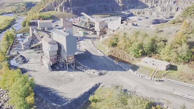
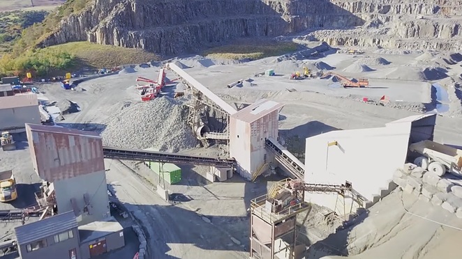
Force Garth Quarry was opened in 1932 and is a key provider of building materials throughout Northern England. Dolerite rock (known locally as whinstone) is quarried from the site, which produces between 250,000 to 300,000 tonnes a year. The quarry is estimated to contain about 18 million tonnes of reserves. In 2012, Cemex UK Operations Limited (currently working the quarry) applied for permission from Durham County Council to expand it and extract a further 5.2 million tonnes over the next 15 years.
“Ilvaite, a rare calcium-iron silicate, is present in the dolerite-pegmatite facies of the Whin Sill at Force Garth Quarry near High Force in Teesdale, Co. Durham. Ilvaite forms part of an association of opaque minerals that includes ilmenite, altered titanomagnetite, titanite and minor sulphides, notably pyrrhotite, chalcopyrite and sphalerite that is characteristic of ilvaite in mafic igneous rocks. Other than the presence of ilvaite and trace amounts of molybdenite there is nothing unusual about the sampled dolerite-pegmatite suggesting that ilvaite may be present in dolerite-pegmatites elsewhere in the Whin Sill. This is the first authenticated occurrence of ilvaite in the British Isles.
The opaque mineralogy of pink aplite from the Whin Sill at Ratcheugh Quarry near Alnwick comprises ilmenite, titanite and pyrite with minor amounts of pyrrhotite, chalcopyrite, iron-rich sphalerite and galena. Much of the sulphide assemblage and associated baryte is later than the crystallisation of the aplite.
In addition, there appears to be nothing petrographically special about the Force Garth dolerite-pegmatite other than the recognition of ilvaite in the mineral assemblage and the presence of altered olivine in the dolerite wall rocks. It is possible that ilvaite is more widespread in northern England than this single occurrence indicates.”
Select Mineral List Type
Standard Detailed Gallery Strunz Chemical ElementsMineral List
4 valid minerals.
Rock Types Recorded
Note: data is currently VERY limited. Please bear with us while we work towards adding this information!
Select Rock List Type
Alphabetical List Tree DiagramDetailed Mineral List:
| ⓘ Calcite Formula: CaCO3 References: (n.d.) Knut Eldjarn collection.from Oxford Museum Collection |
| ⓘ 'Chabazite' |
| ⓘ Ilvaite Formula: CaFe3+Fe2+2(Si2O7)O(OH) References: |
| ⓘ Pectolite Formula: NaCa2Si3O8(OH) |
| ⓘ Prehnite Formula: Ca2Al2Si3O10(OH)2 |
Gallery:
List of minerals arranged by Strunz 10th Edition classification
| Group 5 - Nitrates and Carbonates | |||
|---|---|---|---|
| ⓘ | Calcite | 5.AB.05 | CaCO3 |
| Group 9 - Silicates | |||
| ⓘ | Ilvaite | 9.BE.07 | CaFe3+Fe2+2(Si2O7)O(OH) |
| ⓘ | Pectolite | 9.DG.05 | NaCa2Si3O8(OH) |
| ⓘ | Prehnite | 9.DP.20 | Ca2Al2Si3O10(OH)2 |
| Unclassified | |||
| ⓘ | 'Chabazite' | - | |
List of minerals for each chemical element
| H | Hydrogen | |
|---|---|---|
| H | ⓘ Ilvaite | CaFe3+Fe22+(Si2O7)O(OH) |
| H | ⓘ Pectolite | NaCa2Si3O8(OH) |
| H | ⓘ Prehnite | Ca2Al2Si3O10(OH)2 |
| C | Carbon | |
| C | ⓘ Calcite | CaCO3 |
| O | Oxygen | |
| O | ⓘ Calcite | CaCO3 |
| O | ⓘ Ilvaite | CaFe3+Fe22+(Si2O7)O(OH) |
| O | ⓘ Pectolite | NaCa2Si3O8(OH) |
| O | ⓘ Prehnite | Ca2Al2Si3O10(OH)2 |
| Na | Sodium | |
| Na | ⓘ Pectolite | NaCa2Si3O8(OH) |
| Al | Aluminium | |
| Al | ⓘ Prehnite | Ca2Al2Si3O10(OH)2 |
| Si | Silicon | |
| Si | ⓘ Ilvaite | CaFe3+Fe22+(Si2O7)O(OH) |
| Si | ⓘ Pectolite | NaCa2Si3O8(OH) |
| Si | ⓘ Prehnite | Ca2Al2Si3O10(OH)2 |
| Ca | Calcium | |
| Ca | ⓘ Calcite | CaCO3 |
| Ca | ⓘ Ilvaite | CaFe3+Fe22+(Si2O7)O(OH) |
| Ca | ⓘ Pectolite | NaCa2Si3O8(OH) |
| Ca | ⓘ Prehnite | Ca2Al2Si3O10(OH)2 |
| Fe | Iron | |
| Fe | ⓘ Ilvaite | CaFe3+Fe22+(Si2O7)O(OH) |
Other Regions, Features and Areas containing this locality
British and Irish IslesGroup of Islands
Eurasian PlateTectonic Plate
- AvaloniaVolcanic Arc
EuropeContinent
UK
- England
- North Pennines AreaArea of Outstanding Natural Beauty
- TeesdaleDale
- The PenninesRange of Mountains and Hills
This page contains all mineral locality references listed on mindat.org. This does not claim to be a complete list. If you know of more minerals from this site, please register so you can add to our database. This locality information is for reference purposes only. You should never attempt to
visit any sites listed in mindat.org without first ensuring that you have the permission of the land and/or mineral rights holders
for access and that you are aware of all safety precautions necessary.

Force Garth Quarry, Forest and Frith, County Durham, England, UK