
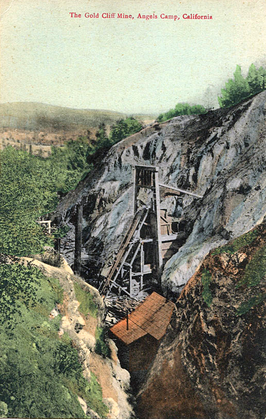
Gold Cliff Mine (Excelsior Mine; Pilot Knob claim; Peachy No. 1 claim; Peachy No. 2 claim; Madison Fairfax claim), Angels Camp, Angels Camp Mining District, Calaveras County, California, USAi
This page is currently not sponsored. Click here to sponsor this page.

Latitude & Longitude (WGS84):
38° 3' 57'' North , 120° 32' 42'' West
Latitude & Longitude (decimal):
Type:
Köppen climate type:
Nearest Settlements:
| Place | Population | Distance |
|---|---|---|
| Angels Camp | 2,677 (2012) | 0.5km |
| Vallecito | 442 (2011) | 6.8km |
| Murphys | 2,213 (2015) | 10.8km |
| Tuttletown | 668 (2011) | 11.1km |
| Copperopolis | 3,671 (2011) | 12.7km |
Nearest Clubs:
Local clubs are the best way to get access to collecting localities
Local clubs are the best way to get access to collecting localities
| Club | Location | Distance |
|---|---|---|
| Calaveras Gem & Mineral Society | Angels Camp, California | 1km |
| Amador County Gem & Mineral Society | Sutter Creek, California | 43km |
A former Au mine located in the SW¼ sec. 33, T3N, R13E, MDM, 0.6 km (0.4 mile) WSW of Angels Camp, on private land. Discovered in 1850. The property covered 25 acres. Operated during the periods 1850-1884, 1884-1920, and a sample was cut in 1930. MRDS database accuracy for this location is not stated. Alternate coordinates provided: 38°03'58"N, 120°32'39"W.
The Gold Cliff Mine was discovered in 1850, but was not mined extensively until after it was taken over by the Utica Gold Mining Company in 1884. A shaft was sunk from the bottom of the open cut and the mine was operated from 1889 until April, 1920, three years longer than the company's larger property, the neighboring Utica Mine. The Gold Cliff mine property was comprised of the Gold Gliff , Pilot Knob, Madison, Specimen, Fairfax, Excelsior. Peachey, and No. 1 and No. 2 placer claims. Adverse economic conditions and falling off in the working efficiency of miners are said to have hastened closing. The Utica Mining Company reported that the total mine production was $2,834,000 (Logan, 1934).
Mineralization is hosted in greenschist and amphibolite. The ore body strikes NW and dips NE at a thickness of 30.48 meters. It is tabular, pinch & swell. The ore is mineralized crushed amphibolite schist cut by numerous quartz veins and veinlets. The dip flattens to as little as 7 degrees at depth. Massive, barren quartz comprises the hanging wall in the upper workings but a tdepth it is grooved amphibolite schist. The Gold Cliff vein system intersects the Utica vein system 2,700 feet below surface. he average dip at surface is 45 degrees. Controls for ore emplacement included ore shoots within mesothermal gold-bearing quartz veins. There is hydrothermal alteration of wall rock. Fine crystals of pyrite carry more ore than coarse crystals. Local rocks include Undivided pre-Cenozoic metavolcanic rocks, unit 2 (undivided).
Regional geologic structures include the Bear Mountains fault zone and the Melones fault zone.
Local structures include a nearly horizontal fault between the 1600 and 1700 foot levels with several hundred feet of displacement. The orebody is displaced to the N.
The geology of the Angels Camp district is complex. Bedrock, which is assigned either to the Calaveras Complex or unnamed units of Jurassic age, consists of a series of northwest-striking beds of amphibolite and chlorite schists, phyllite, greenstone, and metagabbro. Ore deposits occur either in amphibolite and chlorite schist or phyllite. There are three principal northwest striking vein systems in the district. In the westernmost system, the veins are in phyllite. In the center system, which includes the Gold Cliff Mine, the veins are along the western margin of a northwest trending belt of metagabbro. In the eastern system, the ore deposits occur in amphibolite and greenstone. To the east and west of the district, bedrock is composed of slate, impure quartzite, and micaceous schist (Clark, 1970).
The deposit in the Gold Cliff Mine is very similar to that worked in the larger Utica Mine located about one mile to the east. These mines exploited parallel ore bodies called the Gold Cliff vein and Utica vein respectively.
At the surface, the veins were 3000 feet apart. The Gold Cliff vein strikes northwestward and dips 45? NE in the upper workings, but the dip flattens to as little as 7 degrees on the 1700-foot level (Knopf, 1929) causing the veins to converge at about the 2700 foot level in the Utica Mine workings. Despite the common occurrence of high-grade ore bodies at vein intersections in many Mother Lode vein systems, no high-grade ore was encountered at the junction of these veins.
The ore bodies in both mines are not within simple veins like many Mother Lode deposits, but instead consist of numerous lenticular stringer veins separated by various thicknesses of fissured and mineralized amphibolite and chloritic and talcose schist. The stringers range from a few inches to three feet thick and are largely quartz, but carbonate is abundant, especially in the smaller fissures. In the Gold Cliff mine, the stringers strike about N 50? W and dip northeasterly, lying nearly in the planes of schistosity of the country rock (Eisenhauer, 1932). Both the quartz and nearby country rock contain free gold and auriferous pyrite. The schist is greatly altered and pyritized and carries the greater gold values. The schists are largely altered and compose of ankerite and sericite, with subordinate quartz, albite, and pyrite. Rutile is a common accessory forming minute prisms. Pyrite is developed metasomatically in the schists as sharp cubes. In the Gold Cliff Mine, the cubes can attain large size- half an inch or more in dimensions (Knopf, 1929). The large coarse pyrite cubes carried only $5 per ton, and are thought to represent the primary pyrite of the original igneous rock from which the schist was derived. The fine disseminated pyrite crystals of which concentrates yielded concentrates worth $50 to $80 per ton, are thought to the result of hydrothermal alteration and enrichment (Logan, 1936). The quartz veinlets, unless they contain pyrite are poorly mineralized (Knopf, 1929). The average value of the ore mined averaged $2.00 to $2.50 per ton with sulfide concentrates ranging from $30 to $50 per ton (Clark and Lydon, 1962).
In the upper workings, the Gold Cliff ore body was nearly 100 feet thick, but the footwall converges toward the hanging with depth and to the south. The immediate hanging wall of the ore body was a massive barren quartz vein 4 top 6 feet thick. At depth, the hanging wall was a hard, grooved amphibolite schist that stood without timbering and was a major factor in permitting low-cost mining operations (Logan, 1934).
Between the 1600 and 1700-foot levels, a nearly horizontal reverse fault of several hundred feet of displacement offsets the ore body to the north. On the 1700-foot level the lode was also displaced by a steep eastward dipping post mineralization normal fault which had dropped the lode 3 feet on the east side of the fault. The displacement was reported to increase southward along the strike of the fault (Knopf, 1929). On the 1700-foot level the lode was also displaced by a steep eastward dipping post mineralization normal fault which had dropped the lode 3 feet on the east side of the fault. The displacement was reported to increase southward along the strike of the fault (Knopf, 1929).
Workings include surface and underground openings. The upper part of the Gold Cliff workings were developed by an open cut. Deeper workings were accessed through a 3-compartment, 1700- foot inclined shaft. The shaft was inclined 45? to the 1600-foot level, below which it was inclined 12 degrees. Where the vein flattened on the 1700-foot level, a drift was run north 800 feet from the bottom of the 1700 foot shaft and a winze was sunk from near the face to a depth of 270 feet. A northeast crosscut on the 1400-foot level connected with the 1500-foot level of the neighboring Utica Mine. Few additional details of the underground workings are available, but a portion of the workings are shown Clark and Lydon (1962, fig. 10, p. 73). Open stopes with pillars were employed, and little timbering was required.
Ore was hoisted from the inclined shaft and trammed to the mill by electric traction. Ore was crushed with a Blake crusher and treated in a 200-ton, 40-stamp mill (Clark and Lydon, 1962). Battery pulp was concentrated on twenty-four 4-foot Frue vanners. A 90% recovery was made by amalgamation and concentration. Concentrates were valued at $30 to $50 per ton (Tucker, 1915)
Production data are found in: Clark. W. B., and Lydon, P.A., 1962, and Logan (1934).
Clark (1970) reported that that Gold Cliff Mine produced $2,834,000+ in gold (period values). The average value of the ore mined averaged $2.00 to $2.50 per ton with sulfide concentrates ranging from $30 to $50 per ton (Clark and Lydon, 1962).
Select Mineral List Type
Standard Detailed Gallery Strunz Chemical ElementsDetailed Mineral List:
| ⓘ Margarite Formula: CaAl2(Al2Si2O10)(OH)2 References: |
| ⓘ Native Gold Formula: Au |
| ⓘ Pyrite Formula: FeS2 |
| ⓘ Quartz Formula: SiO2 |
Gallery:
List of minerals arranged by Strunz 10th Edition classification
| Group 1 - Elements | |||
|---|---|---|---|
| ⓘ | Native Gold | 1.AA.05 | Au |
| Group 2 - Sulphides and Sulfosalts | |||
| ⓘ | Pyrite | 2.EB.05a | FeS2 |
| Group 4 - Oxides and Hydroxides | |||
| ⓘ | Quartz | 4.DA.05 | SiO2 |
| Group 9 - Silicates | |||
| ⓘ | Margarite | 9.EC.30 | CaAl2(Al2Si2O10)(OH)2 |
List of minerals for each chemical element
| H | Hydrogen | |
|---|---|---|
| H | ⓘ Margarite | CaAl2(Al2Si2O10)(OH)2 |
| O | Oxygen | |
| O | ⓘ Margarite | CaAl2(Al2Si2O10)(OH)2 |
| O | ⓘ Quartz | SiO2 |
| Al | Aluminium | |
| Al | ⓘ Margarite | CaAl2(Al2Si2O10)(OH)2 |
| Si | Silicon | |
| Si | ⓘ Margarite | CaAl2(Al2Si2O10)(OH)2 |
| Si | ⓘ Quartz | SiO2 |
| S | Sulfur | |
| S | ⓘ Pyrite | FeS2 |
| Ca | Calcium | |
| Ca | ⓘ Margarite | CaAl2(Al2Si2O10)(OH)2 |
| Fe | Iron | |
| Fe | ⓘ Pyrite | FeS2 |
| Au | Gold | |
| Au | ⓘ Native Gold | Au |
Other Databases
| Link to USGS MRDS: | 10102723 |
|---|
Other Regions, Features and Areas containing this locality
North AmericaContinent
North America PlateTectonic Plate
- Shoofly-Olds Ferry DomainDomain
- Sierra Nevada BatholithVolcanic Arc
This page contains all mineral locality references listed on mindat.org. This does not claim to be a complete list. If you know of more minerals from this site, please register so you can add to our database. This locality information is for reference purposes only. You should never attempt to
visit any sites listed in mindat.org without first ensuring that you have the permission of the land and/or mineral rights holders
for access and that you are aware of all safety precautions necessary.

Gold Cliff Mine, Angels Camp, Angels Camp Mining District, Calaveras County, California, USA