
Ystumtuen Mine, Ystumtuen, Cwmrheidol, Ceredigion, Wales, UKi
| Regional Level Types | |
|---|---|
| Ystumtuen Mine | Mine (Abandoned) |
| Ystumtuen | - not defined - |
| Cwmrheidol | - not defined - |
| Ceredigion | County |
| Wales | Country |
| UK | Country |
This page is currently not sponsored. Click here to sponsor this page.


Latitude & Longitude (WGS84):
52° 23' 31'' North , 3° 51' 43'' West
Latitude & Longitude (decimal):
UK National Grid Reference:
SN733788
Type:
Mine (Abandoned) - last checked 2020
Köppen climate type:
Nearest Settlements:
| Place | Population | Distance |
|---|---|---|
| Capel Bangor | 256 (2017) | 7.4km |
| Llanilar | 1,085 (2017) | 11.8km |
| Pontrhydfendigaid | 712 (2017) | 12.2km |
| Bow Street | 1,572 (2017) | 12.5km |
| Penparcau | 3,088 (2011) | 14.4km |
Other/historical names associated with this locality:
Dyfed; Cardiganshire
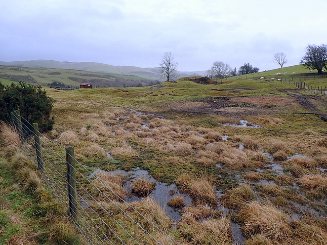
Approaching the site from the village of Ystumtuen the narrow lane climbs steeply and then turns sharply left defining the eastern and northern boundaries of the workings. In all the site is approximately 300m x 100m aligned east-west, divided into 2 roughly equal halves by a north-south farm track.
Within the bend of the road is an east-west aligned open working associated with small spoil heaps. In the middle of the site on the southern edge beside the farm track is a fenced shaft collar. The site generally has the appearance of many low mounds of spoil now grassed over.
At the time of this visit (Dec 2017) the site was being used as pony paddocks and no closer inspection was possible other than from the road.
It is however also possible that work took place to the north of the road. Though most of that is now tree covered there is a place occupied by farm machinery that has a prominent mound of what could be spoil.
Select Mineral List Type
Standard Detailed Gallery Strunz Chemical ElementsCommodity List
This is a list of exploitable or exploited mineral commodities recorded at this locality.Mineral List
6 valid minerals.
Detailed Mineral List:
| ⓘ Galena Formula: PbS |
| ⓘ Marcasite Formula: FeS2 |
| ⓘ Pyrite Formula: FeS2 |
| ⓘ Quartz Formula: SiO2 |
| ⓘ Sphalerite Formula: ZnS |
| ⓘ Strontianite Formula: SrCO3 |
Gallery:
List of minerals arranged by Strunz 10th Edition classification
| Group 2 - Sulphides and Sulfosalts | |||
|---|---|---|---|
| ⓘ | Sphalerite | 2.CB.05a | ZnS |
| ⓘ | Galena | 2.CD.10 | PbS |
| ⓘ | Pyrite | 2.EB.05a | FeS2 |
| ⓘ | Marcasite | 2.EB.10a | FeS2 |
| Group 4 - Oxides and Hydroxides | |||
| ⓘ | Quartz | 4.DA.05 | SiO2 |
| Group 5 - Nitrates and Carbonates | |||
| ⓘ | Strontianite | 5.AB.15 | SrCO3 |
List of minerals for each chemical element
| C | Carbon | |
|---|---|---|
| C | ⓘ Strontianite | SrCO3 |
| O | Oxygen | |
| O | ⓘ Quartz | SiO2 |
| O | ⓘ Strontianite | SrCO3 |
| Si | Silicon | |
| Si | ⓘ Quartz | SiO2 |
| S | Sulfur | |
| S | ⓘ Galena | PbS |
| S | ⓘ Marcasite | FeS2 |
| S | ⓘ Pyrite | FeS2 |
| S | ⓘ Sphalerite | ZnS |
| Fe | Iron | |
| Fe | ⓘ Marcasite | FeS2 |
| Fe | ⓘ Pyrite | FeS2 |
| Zn | Zinc | |
| Zn | ⓘ Sphalerite | ZnS |
| Sr | Strontium | |
| Sr | ⓘ Strontianite | SrCO3 |
| Pb | Lead | |
| Pb | ⓘ Galena | PbS |
Other Regions, Features and Areas containing this locality
British and Irish IslesGroup of Islands
Eurasian PlateTectonic Plate
- AvaloniaVolcanic Arc
EuropeContinent
This page contains all mineral locality references listed on mindat.org. This does not claim to be a complete list. If you know of more minerals from this site, please register so you can add to our database. This locality information is for reference purposes only. You should never attempt to
visit any sites listed in mindat.org without first ensuring that you have the permission of the land and/or mineral rights holders
for access and that you are aware of all safety precautions necessary.

Ystumtuen Mine, Ystumtuen, Cwmrheidol, Ceredigion, Wales, UK