
Camp Verde Salt Mine, Camp Verde, Camp Verde Mining District, Yavapai County, Arizona, USAi
| Regional Level Types | |
|---|---|
| Camp Verde Salt Mine | Mine |
| Camp Verde | Town |
| Camp Verde Mining District | Mining District |
| Yavapai County | County |
| Arizona | State |
| USA | Country |
This page is currently not sponsored. Click here to sponsor this page.


Latitude & Longitude (WGS84):
34° 32' 42'' North , 111° 52' 26'' West
Latitude & Longitude (decimal):
Type:
Köppen climate type:
Nearest Settlements:
| Place | Population | Distance |
|---|---|---|
| Camp Verde | 11,155 (2017) | 2.7km |
| Lake Montezuma | 4,706 (2011) | 13.1km |
| Cornville | 3,280 (2011) | 19.7km |
| Verde Village | 11,605 (2011) | 22.3km |
| Cottonwood | 11,818 (2017) | 24.9km |
Nearest Clubs:
Local clubs are the best way to get access to collecting localities
Local clubs are the best way to get access to collecting localities
| Club | Location | Distance |
|---|---|---|
| Mingus Gem & Mineral Club | Cottonwood, Arizona | 25km |
| Verde River Rockhounds | Cottonwood, Arizona | 25km |
| Sedona Gem & Mineral Club | Sedona, Arizona | 38km |
| Prescott Gem & Mineral Club | Prescott Valley, Arizona | 41km |
Other/historical names associated with this locality:
Wingfield Gypsum; Sodium Products Corp. Mine; Graham Wingfield Sulphate Mine; Graham-Wingfield Sulfate Ground
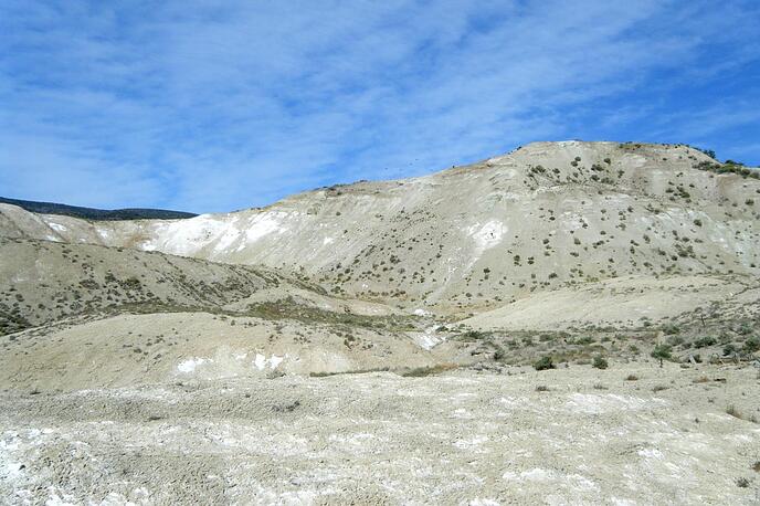
A former surface and underground salt-clay-gypsum mine located about 2 miles West of Camp Verde, SE of Clarkdale, on the West side of the Verde River.
This mine produced in Pre-Columbian times (was working in 1492) and worked again in the 1920s to 1933.
NOTE: Alternate coordinates provided: 34.5833N, 111.8944W.
Mineralization is hosted in the Verde Formation. Local structures include the Verde Fault Zone.
The Camp Verde Salt Mine is one of the oldest known mines in the United States and some experts note that the area was likely worked for salt as long as 2000 years ago. Rare artifacts have shown that the mine was worked for salt at least before the arrival of Columbus (pre-Columbian) in the 14th and 15th centuries. The mummified body of an Indian miner was found in the underground workings during the most active mining period in the early 20th century. The establishment of Ft. Verde in 1871 brought new attention to the salt deposit and some of this was used for human consumption but the majority was used as stock salt. In the 1920s, the Western Chemical Company operated an open pit on the property. The ore was used in the processing of paper pulp. Later efforts in the early 1930s by the Arizona Chemical Company employed underground mining techniques and 14 tunnels were driven in horizontal strata for several hundred feet and followed rich layers of salt. At the time, about 75 men were employed (about half were Apache Indians) and the mine produced nearly 100 tons of "salt cake" daily, making the Camp Verde Salt mine the most productive in the country. This success was short-lived and duty-free and purer German ore entered the market in 1933 and essentially forced the closure of the mine. Attempts were made as late as the 1960's to market the deposit but current market needs demand 99% purity and the Camp Verde salt deposit is limited to 92% purity. Additionally, much larger deposits in the US and Canada exist and the mine has been dormant ever since.
Geology: The origin of the Camp Verde salt deposit can be traced back to massive volcanic events some 13 million years ago in the Hackberry Mountain and Thirteen-mile Rock volcanic center about 12 miles southeast of present-day Camp Verde. During this time of massive geologic upheaval, much of central Arizona was faulted into deep basins and high ranges. The deep basins captured eroded materials from the neighboring mountains and the southern limit of the Verde Valley was blocked by a massive volcanic flow and continued volcanic eruptions added more material to this natural dam. This basin captured materials and water and held it like a huge lake. Seasonal periods of acute dryness led to the evaporation of the super-saline waters and essentially left behind the salt and gypsum as layers within the Verde Valley sediments. The volcanic dam that blocked the southern end of the Verde Valley eventually eroded and normal drainage was achieved.
NOTE: The green crystals listed as having come from this location are all artificially colored. Secondly, the calcite crystals listed for this location are not from this location but from the Copper Canyon location. Tests showed that only gypsum was found as pseudomorphs at the Salt Works.
Select Mineral List Type
Standard Detailed Gallery Strunz Chemical ElementsCommodity List
This is a list of exploitable or exploited mineral commodities recorded at this locality.Mineral List
7 valid minerals.
Detailed Mineral List:
| ⓘ Aragonite Formula: CaCO3 Habit: Pseudo-hexagonal twinned crystals aggregated into ball-like clusters. Description: Ball-like aggregates of pseudo-hexagonal crystals & as pseudomorphs after glauberite. References: |
| ⓘ Calcite Formula: CaCO3 Colour: buff to white Description: as pseudomorphs after glauberite |
| ⓘ 'Clay minerals' |
| ⓘ Glauberite Formula: Na2Ca(SO4)2 |
| ⓘ Gypsum Formula: CaSO4 · 2H2O |
| ⓘ Halite Formula: NaCl |
| ⓘ Mirabilite Formula: Na2SO4 · 10H2O |
| ⓘ Thénardite Formula: Na2SO4 |
Gallery:

List of minerals arranged by Strunz 10th Edition classification
| Group 3 - Halides | |||
|---|---|---|---|
| ⓘ | Halite | 3.AA.20 | NaCl |
| Group 5 - Nitrates and Carbonates | |||
| ⓘ | Calcite | 5.AB.05 | CaCO3 |
| ⓘ | Aragonite | 5.AB.15 | CaCO3 |
| Group 7 - Sulphates, Chromates, Molybdates and Tungstates | |||
| ⓘ | Glauberite | 7.AD.25 | Na2Ca(SO4)2 |
| ⓘ | Thénardite | 7.AD.25 | Na2SO4 |
| ⓘ | Mirabilite | 7.CD.10 | Na2SO4 · 10H2O |
| ⓘ | Gypsum | 7.CD.40 | CaSO4 · 2H2O |
| Unclassified | |||
| ⓘ | 'Clay minerals' | - | |
List of minerals for each chemical element
| H | Hydrogen | |
|---|---|---|
| H | ⓘ Gypsum | CaSO4 · 2H2O |
| H | ⓘ Mirabilite | Na2SO4 · 10H2O |
| C | Carbon | |
| C | ⓘ Aragonite | CaCO3 |
| C | ⓘ Calcite | CaCO3 |
| O | Oxygen | |
| O | ⓘ Aragonite | CaCO3 |
| O | ⓘ Calcite | CaCO3 |
| O | ⓘ Glauberite | Na2Ca(SO4)2 |
| O | ⓘ Gypsum | CaSO4 · 2H2O |
| O | ⓘ Mirabilite | Na2SO4 · 10H2O |
| O | ⓘ Thénardite | Na2SO4 |
| Na | Sodium | |
| Na | ⓘ Glauberite | Na2Ca(SO4)2 |
| Na | ⓘ Halite | NaCl |
| Na | ⓘ Mirabilite | Na2SO4 · 10H2O |
| Na | ⓘ Thénardite | Na2SO4 |
| S | Sulfur | |
| S | ⓘ Glauberite | Na2Ca(SO4)2 |
| S | ⓘ Gypsum | CaSO4 · 2H2O |
| S | ⓘ Mirabilite | Na2SO4 · 10H2O |
| S | ⓘ Thénardite | Na2SO4 |
| Cl | Chlorine | |
| Cl | ⓘ Halite | NaCl |
| Ca | Calcium | |
| Ca | ⓘ Aragonite | CaCO3 |
| Ca | ⓘ Calcite | CaCO3 |
| Ca | ⓘ Glauberite | Na2Ca(SO4)2 |
| Ca | ⓘ Gypsum | CaSO4 · 2H2O |
Other Regions, Features and Areas containing this locality
North AmericaContinent
North America PlateTectonic Plate
- Basin and Range BasinsBasin
- Great Plains DomainDomain
- Southern Basin and RangeWide Rift
This page contains all mineral locality references listed on mindat.org. This does not claim to be a complete list. If you know of more minerals from this site, please register so you can add to our database. This locality information is for reference purposes only. You should never attempt to
visit any sites listed in mindat.org without first ensuring that you have the permission of the land and/or mineral rights holders
for access and that you are aware of all safety precautions necessary.

Camp Verde Salt Mine, Camp Verde, Camp Verde Mining District, Yavapai County, Arizona, USA