
Sunstone Knoll, Deseret, Millard County, Utah, USAi
| Regional Level Types | |
|---|---|
| Sunstone Knoll | Deposit |
| Deseret | Town |
| Millard County | County |
| Utah | State |
| USA | Country |
This page is currently not sponsored. Click here to sponsor this page.


Latitude & Longitude (WGS84):
39° 8' 45'' North , 112° 43' 0'' West
Latitude & Longitude (decimal):
Type:
Köppen climate type:
Nearest Settlements:
| Place | Population | Distance |
|---|---|---|
| Deseret | 353 (2011) | 16.6km |
| Hinckley | 695 (2017) | 20.3km |
| Delta | 3,482 (2017) | 25.9km |
| Sutherland | 165 (2011) | 27.9km |
| Holden | 373 (2017) | 38.8km |
Other/historical names associated with this locality:
Labradorite deposit
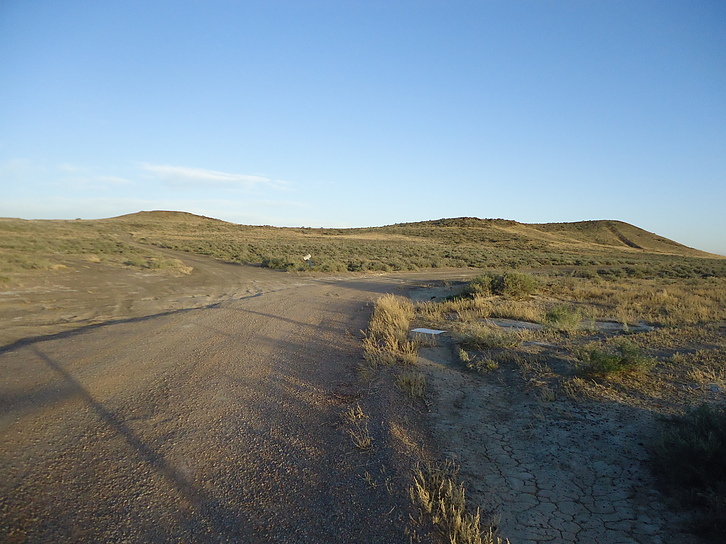
Weathered basalt on highway 257 between Delta and Milford.
The Utah Geologic Survey states that
A feldspar-gemstone occurrence located in the SE¼SW¼NE¼ Section 23, Township 19 South, Range 8 West, Salt Lake Meridian, 16.3 km (10.1 miles) south-southwest of Deseret, along highway 257, on Bureau of Land Management administered land (located claim). The USGS MRDS database stated accuracy for this locality is 100 meters.
Mineralization is a volcanic deposit of Pleistocene basalt with feldspar crystals. The ore body is a blanket in form with a thickness of 15.24 meters, width of 152.4 meters, length of 304.8 meters, depth-to-top of 0.0 meters, and a depth-to-bottom of 15.24 meters. Local rocks include Quaternary Lake Bonneville deposits.
Workings include surface and underground openings comprised of a small open shaft at 50 feet deep plus several bulldozer cuts. The overall length is 167.64 meters, overall width is 30.48 meters and the overall depth is 15.24 meters.
The Utah Geologic Survey states that
Sunstone Knoll is formed of volcanic vents that erupted during the early Pleistocene (1.6 million years to about 750,000 years ago). These eruptions left deposits of basaltic lava and volcanic breccia (angular, broken rock fragments held together in a matrix of finer grained material). Sunstone is a transparent, yellowish labradorite (a plagioclase feldspar mineral) found as crystals in these volcanic rocks and on the flats surrounding the knoll.
A feldspar-gemstone occurrence located in the SE¼SW¼NE¼ Section 23, Township 19 South, Range 8 West, Salt Lake Meridian, 16.3 km (10.1 miles) south-southwest of Deseret, along highway 257, on Bureau of Land Management administered land (located claim). The USGS MRDS database stated accuracy for this locality is 100 meters.
Mineralization is a volcanic deposit of Pleistocene basalt with feldspar crystals. The ore body is a blanket in form with a thickness of 15.24 meters, width of 152.4 meters, length of 304.8 meters, depth-to-top of 0.0 meters, and a depth-to-bottom of 15.24 meters. Local rocks include Quaternary Lake Bonneville deposits.
Workings include surface and underground openings comprised of a small open shaft at 50 feet deep plus several bulldozer cuts. The overall length is 167.64 meters, overall width is 30.48 meters and the overall depth is 15.24 meters.
Select Mineral List Type
Standard Detailed Gallery Strunz Chemical ElementsCommodity List
This is a list of exploitable or exploited mineral commodities recorded at this locality.Mineral List
1 valid mineral.
Rock Types Recorded
Select Rock List Type
Alphabetical List Tree DiagramDetailed Mineral List:
| ⓘ Anorthite Formula: Ca(Al2Si2O8) |
| ⓘ Anorthite var. Labradorite Formula: (Ca,Na)[Al(Al,Si)Si2O8] |
Gallery:

List of minerals arranged by Strunz 10th Edition classification
| Group 9 - Silicates | |||
|---|---|---|---|
| ⓘ | Anorthite | 9.FA.35 | Ca(Al2Si2O8) |
| ⓘ | var. Labradorite | 9.FA.35 | (Ca,Na)[Al(Al,Si)Si2O8] |
List of minerals for each chemical element
| O | Oxygen | |
|---|---|---|
| O | ⓘ Anorthite | Ca(Al2Si2O8) |
| O | ⓘ Anorthite var. Labradorite | (Ca,Na)[Al(Al,Si)Si2O8] |
| Na | Sodium | |
| Na | ⓘ Anorthite var. Labradorite | (Ca,Na)[Al(Al,Si)Si2O8] |
| Al | Aluminium | |
| Al | ⓘ Anorthite | Ca(Al2Si2O8) |
| Al | ⓘ Anorthite var. Labradorite | (Ca,Na)[Al(Al,Si)Si2O8] |
| Si | Silicon | |
| Si | ⓘ Anorthite | Ca(Al2Si2O8) |
| Si | ⓘ Anorthite var. Labradorite | (Ca,Na)[Al(Al,Si)Si2O8] |
| Ca | Calcium | |
| Ca | ⓘ Anorthite | Ca(Al2Si2O8) |
| Ca | ⓘ Anorthite var. Labradorite | (Ca,Na)[Al(Al,Si)Si2O8] |
Other Databases
| Link to USGS MRDS: | 10087082 |
|---|
Other Regions, Features and Areas containing this locality
North AmericaContinent
North America PlateTectonic Plate
- Basin and Range BasinsBasin
- Mojave DomainDomain
- Northern Basin and RangeWide Rift
- Oquirrh BasinBasin
This page contains all mineral locality references listed on mindat.org. This does not claim to be a complete list. If you know of more minerals from this site, please register so you can add to our database. This locality information is for reference purposes only. You should never attempt to
visit any sites listed in mindat.org without first ensuring that you have the permission of the land and/or mineral rights holders
for access and that you are aware of all safety precautions necessary.

Sunstone Knoll, Deseret, Millard County, Utah, USA