
Titus Canyon, Grapevine Mountains, Inyo County, California, USAi
| Regional Level Types | |
|---|---|
| Titus Canyon | Canyon |
| Grapevine Mountains | Mountain Range |
| Inyo County | County |
| California | State |
| USA | Country |
This page is currently not sponsored. Click here to sponsor this page.




Latitude & Longitude (WGS84):
36° 49' 38'' North , 117° 6' 48'' West
Latitude & Longitude (decimal):
Type:
Köppen climate type:
Nearest Settlements:
| Place | Population | Distance |
|---|---|---|
| Beatty | 1,010 (2011) | 32.8km |
An ENE-WSW-oriented canyon crossing the Grapevine Mountains of the Amargosa Range in Death Valley National Park. Its head is located about 2 km northwest of Leadfield ghost town and its mouth is at the trailhead parking in Death Valley. Titus Canyon Road is a 1-way drive from Daylight Pass Road in Nevada that first heads west into a canyon leading to Leadfield via Red Pass then after 2 more km turns WSW to follow Titus Canyon.
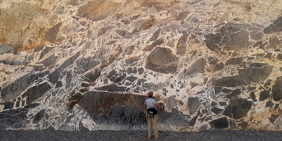
Exposed along it are late Proterozoic to Paleozoic sedimentary rocks. In the center of the canyon is an overturned, anticlinal structure. Near the west end, within Cambrian dolostone of the Bonanza King Formation, are numerous, +/-1-meter solution voids hosting honey-brown travertine deposits and several intensely-brecciated zones cemented by very-coarse-grained, white calcite. Breccia clasts are up to 4 meters and the calcite cement grains are up to about 15 cm.
Coordinates are for the approximate middle of the canyon length, near the anticline.
Aragonite crystal clusters labeled "Titus Canyon" are actually reportedly from Leadfield, which is not in Titus Canyon proper. See: https://www.mindat.org/loc-257386.html
Select Mineral List Type
Standard Detailed Gallery Strunz Chemical ElementsMineral List
1 valid mineral.
Rock Types Recorded
Note: data is currently VERY limited. Please bear with us while we work towards adding this information!
Select Rock List Type
Alphabetical List Tree DiagramDetailed Mineral List:
| ⓘ Calcite Formula: CaCO3 Colour: white Description: Masses cementing brecciated dolostone with coarse-grained crystals up to about 15 cm. References: Harold Moritz field observationsIdentified by Harold Moritz: Visual Identification |
Gallery:
List of minerals arranged by Strunz 10th Edition classification
| Group 5 - Nitrates and Carbonates | |||
|---|---|---|---|
| ⓘ | Calcite | 5.AB.05 | CaCO3 |
List of minerals for each chemical element
| C | Carbon | |
|---|---|---|
| C | ⓘ Calcite | CaCO3 |
| O | Oxygen | |
| O | ⓘ Calcite | CaCO3 |
| Ca | Calcium | |
| Ca | ⓘ Calcite | CaCO3 |
Other Regions, Features and Areas containing this locality
North AmericaContinent
North America PlateTectonic Plate
- Antler Foreland BasinBasin
- Basin and Range BasinsBasin
- Mojave DomainDomain
- Southern Basin and RangeWide Rift
USA
- Death Valley National ParkNational Park
This page contains all mineral locality references listed on mindat.org. This does not claim to be a complete list. If you know of more minerals from this site, please register so you can add to our database. This locality information is for reference purposes only. You should never attempt to
visit any sites listed in mindat.org without first ensuring that you have the permission of the land and/or mineral rights holders
for access and that you are aware of all safety precautions necessary.

Titus Canyon, Grapevine Mountains, Inyo County, California, USA