
Mount Somers, Ashburton District, Canterbury Region, New Zealandi
| Regional Level Types | |
|---|---|
| Mount Somers | Mountain |
| Ashburton District | District |
| Canterbury Region | Region |
| New Zealand | Country |
This page is currently not sponsored. Click here to sponsor this page.

Latitude & Longitude (WGS84):
43° 37' 8'' South , 171° 22' 27'' East
Latitude & Longitude (decimal):
Type:
Köppen climate type:
The almandine originally listed relates to the Mount Somers Volcanics, rather than a mine or specimen location. It is based on several technical reports, which are listed below, on this rock and neighbouring units. Fe rich almandine is found in rhyolite, as colourless, yellow, greenish, red-brown, red hexagonal or octahedral crystals to 3mms; or altered atoll shaped masses surrounded and infilled with iron oxides. It is relatively uncommon, consisting of up to 0.15% of the rock. No information could be found of detrital garnets in streams, or other locations.
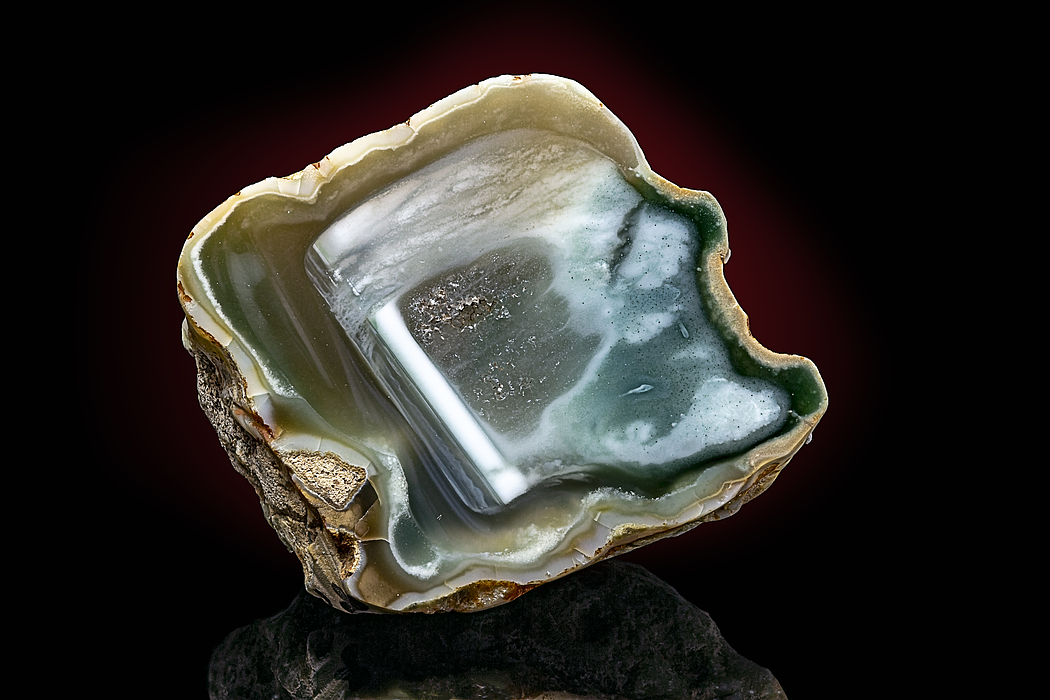
However all is not lost, as the area has been a hunting ground for agate for the past one hundred years, and has been seen for sale. The best of the material can match most agate found overseas. The bad news is most is found on private property, or the Mount Somers Conservation Reserve, where collecting is now banned. Sharks teeth, and mollusc fossils have been found in the past at the Cavendish Quarry.
Coal was mined from the Woolshed Gully area from 1864 to 1968. The Blackburn coal mine is the only one with anything to see, and can be found on the Woolshed Creek Walk. The coal was transported to the railhead at the Mount Somers town, by a tramway. This was constructed by the Ashburton County Council then leased to third parties. Half-way between the mines and town were lime kilns, which required coal from the mines. The constantly changing ownership over all these enterprises caused regular arguments, and disagreements between the various parties. The old tramway follows the Ashburton Gorge Road, and access road to Woolshed Creek. The old lime kilns can still be seen bordering the north side of Ashburton Gorge Road, and a little further on, and a short walk is an old limestone miner's cottage. Some lime mining still takes place in the district for agricultural purposes.
Limestone for building purposes, and later silica sand for glass manufacture was also conducted in the area. The quarries can be seen for both on the north side of the Ashburton Gorge Road. Two limestone quarries were developed from the 1880's by the relevant landowners, Hon. W.S. Peter, and A.E. Peache. Silica sand for glass was identified in the 1920's, with intermittent mining until recent times. Small scale mining has taken place in the past for pottery clay.
Staveley is a church, hall and tea rooms, on the main highway a short distance north of Mount Somers. A couple of historic lime kilns can be seen near the car park to the Sharplin Falls walk. There is also a small local history and geology museum in the hamlet, but good planning is needed. According to their website, the museum is open 1-3 pm, 'most' Sundays in Spring and Summer.
However all is not lost, as the area has been a hunting ground for agate for the past one hundred years, and has been seen for sale. The best of the material can match most agate found overseas. The bad news is most is found on private property, or the Mount Somers Conservation Reserve, where collecting is now banned. Sharks teeth, and mollusc fossils have been found in the past at the Cavendish Quarry.
Coal was mined from the Woolshed Gully area from 1864 to 1968. The Blackburn coal mine is the only one with anything to see, and can be found on the Woolshed Creek Walk. The coal was transported to the railhead at the Mount Somers town, by a tramway. This was constructed by the Ashburton County Council then leased to third parties. Half-way between the mines and town were lime kilns, which required coal from the mines. The constantly changing ownership over all these enterprises caused regular arguments, and disagreements between the various parties. The old tramway follows the Ashburton Gorge Road, and access road to Woolshed Creek. The old lime kilns can still be seen bordering the north side of Ashburton Gorge Road, and a little further on, and a short walk is an old limestone miner's cottage. Some lime mining still takes place in the district for agricultural purposes.
Limestone for building purposes, and later silica sand for glass manufacture was also conducted in the area. The quarries can be seen for both on the north side of the Ashburton Gorge Road. Two limestone quarries were developed from the 1880's by the relevant landowners, Hon. W.S. Peter, and A.E. Peache. Silica sand for glass was identified in the 1920's, with intermittent mining until recent times. Small scale mining has taken place in the past for pottery clay.
Staveley is a church, hall and tea rooms, on the main highway a short distance north of Mount Somers. A couple of historic lime kilns can be seen near the car park to the Sharplin Falls walk. There is also a small local history and geology museum in the hamlet, but good planning is needed. According to their website, the museum is open 1-3 pm, 'most' Sundays in Spring and Summer.
Select Mineral List Type
Standard Detailed Gallery Strunz Chemical ElementsCommodity List
This is a list of exploitable or exploited mineral commodities recorded from this region.Mineral List
Mineral list contains entries from the region specified including sub-localities8 valid minerals.
Rock Types Recorded
Rock list contains entries from the region specified including sub-localities
Select Rock List Type
Alphabetical List Tree DiagramDetailed Mineral List:
Gallery:

List of minerals arranged by Strunz 10th Edition classification
| Group 2 - Sulphides and Sulfosalts | |||
|---|---|---|---|
| ⓘ | Pyrite | 2.EB.05a | FeS2 |
| Group 4 - Oxides and Hydroxides | |||
| ⓘ | Quartz var. Agate | 4.DA.05 | SiO2 |
| ⓘ | var. Amethyst | 4.DA.05 | SiO2 |
| ⓘ | var. Chalcedony | 4.DA.05 | SiO2 |
| ⓘ | 4.DA.05 | SiO2 | |
| ⓘ | Cassiterite | 4.DB.05 | SnO2 |
| Group 5 - Nitrates and Carbonates | |||
| ⓘ | Calcite | 5.AB.05 | CaCO3 |
| ⓘ | Siderite | 5.AB.05 | FeCO3 |
| Group 9 - Silicates | |||
| ⓘ | Almandine | 9.AD.25 | Fe2+3Al2(SiO4)3 |
| ⓘ | Clinochlore | 9.EC.55 | Mg5Al(AlSi3O10)(OH)8 |
| ⓘ | Kaolinite | 9.ED.05 | Al2(Si2O5)(OH)4 |
| Unclassified | |||
| ⓘ | 'Chlorite Group var. Delessite' | - | (Mg,Fe,Fe,Al)(Si,Al)4O10(O,OH)8 |
| ⓘ | 'Glauconite' | - | K0.60-0.85(Fe3+,Mg,Al)2(Si,Al)4O10](OH)2 |
| ⓘ | 'Mica Group' | - | |
List of minerals for each chemical element
| H | Hydrogen | |
|---|---|---|
| H | ⓘ Clinochlore | Mg5Al(AlSi3O10)(OH)8 |
| H | ⓘ Chlorite Group var. Delessite | (Mg,Fe,Fe,Al)(Si,Al)4O10(O,OH)8 |
| H | ⓘ Glauconite | K0.60-0.85(Fe3+,Mg,Al)2(Si,Al)4O10](OH)2 |
| H | ⓘ Kaolinite | Al2(Si2O5)(OH)4 |
| C | Carbon | |
| C | ⓘ Calcite | CaCO3 |
| C | ⓘ Siderite | FeCO3 |
| O | Oxygen | |
| O | ⓘ Quartz var. Agate | SiO2 |
| O | ⓘ Quartz var. Amethyst | SiO2 |
| O | ⓘ Almandine | Fe32+Al2(SiO4)3 |
| O | ⓘ Calcite | CaCO3 |
| O | ⓘ Cassiterite | SnO2 |
| O | ⓘ Quartz var. Chalcedony | SiO2 |
| O | ⓘ Clinochlore | Mg5Al(AlSi3O10)(OH)8 |
| O | ⓘ Chlorite Group var. Delessite | (Mg,Fe,Fe,Al)(Si,Al)4O10(O,OH)8 |
| O | ⓘ Glauconite | K0.60-0.85(Fe3+,Mg,Al)2(Si,Al)4O10](OH)2 |
| O | ⓘ Kaolinite | Al2(Si2O5)(OH)4 |
| O | ⓘ Quartz | SiO2 |
| O | ⓘ Siderite | FeCO3 |
| Mg | Magnesium | |
| Mg | ⓘ Clinochlore | Mg5Al(AlSi3O10)(OH)8 |
| Mg | ⓘ Chlorite Group var. Delessite | (Mg,Fe,Fe,Al)(Si,Al)4O10(O,OH)8 |
| Mg | ⓘ Glauconite | K0.60-0.85(Fe3+,Mg,Al)2(Si,Al)4O10](OH)2 |
| Al | Aluminium | |
| Al | ⓘ Almandine | Fe32+Al2(SiO4)3 |
| Al | ⓘ Clinochlore | Mg5Al(AlSi3O10)(OH)8 |
| Al | ⓘ Chlorite Group var. Delessite | (Mg,Fe,Fe,Al)(Si,Al)4O10(O,OH)8 |
| Al | ⓘ Glauconite | K0.60-0.85(Fe3+,Mg,Al)2(Si,Al)4O10](OH)2 |
| Al | ⓘ Kaolinite | Al2(Si2O5)(OH)4 |
| Si | Silicon | |
| Si | ⓘ Quartz var. Agate | SiO2 |
| Si | ⓘ Quartz var. Amethyst | SiO2 |
| Si | ⓘ Almandine | Fe32+Al2(SiO4)3 |
| Si | ⓘ Quartz var. Chalcedony | SiO2 |
| Si | ⓘ Clinochlore | Mg5Al(AlSi3O10)(OH)8 |
| Si | ⓘ Chlorite Group var. Delessite | (Mg,Fe,Fe,Al)(Si,Al)4O10(O,OH)8 |
| Si | ⓘ Glauconite | K0.60-0.85(Fe3+,Mg,Al)2(Si,Al)4O10](OH)2 |
| Si | ⓘ Kaolinite | Al2(Si2O5)(OH)4 |
| Si | ⓘ Quartz | SiO2 |
| S | Sulfur | |
| S | ⓘ Pyrite | FeS2 |
| K | Potassium | |
| K | ⓘ Glauconite | K0.60-0.85(Fe3+,Mg,Al)2(Si,Al)4O10](OH)2 |
| Ca | Calcium | |
| Ca | ⓘ Calcite | CaCO3 |
| Fe | Iron | |
| Fe | ⓘ Almandine | Fe32+Al2(SiO4)3 |
| Fe | ⓘ Chlorite Group var. Delessite | (Mg,Fe,Fe,Al)(Si,Al)4O10(O,OH)8 |
| Fe | ⓘ Glauconite | K0.60-0.85(Fe3+,Mg,Al)2(Si,Al)4O10](OH)2 |
| Fe | ⓘ Pyrite | FeS2 |
| Fe | ⓘ Siderite | FeCO3 |
| Sn | Tin | |
| Sn | ⓘ Cassiterite | SnO2 |
Localities in this Region
- Canterbury Region
- Ashburton District
- Canterbury Region
Other Regions, Features and Areas containing this locality
Australian Plate
- Torlesse TerraneAccretionary Complex
New Zealand
- South IslandIsland
- Southern AlpsMountain Range
Pacific PlateTectonic Plate
This page contains all mineral locality references listed on mindat.org. This does not claim to be a complete list. If you know of more minerals from this site, please register so you can add to our database. This locality information is for reference purposes only. You should never attempt to
visit any sites listed in mindat.org without first ensuring that you have the permission of the land and/or mineral rights holders
for access and that you are aware of all safety precautions necessary.
References
Wood, C. P. (1974) Petrogenesis of garnet-bearing rhyolites from Canterbury, New Zealand. New Zealand Journal of Geology and Geophysics, 17 (4) 759-787 doi:10.1080/00288306.1974.10418225

Mt Somers agate sites, Mount Somers, Ashburton District, Canterbury Region, New Zealand