
Tungsten Chief Mine (Tungsten Chief group; Rocky Point Mine; Good Hope Mine; Ophir-Zuck Mine; Wall Street Mine; First Landing Mine), Havilah, Clear Creek Mining District, Kern County, California, USAi
This page is currently not sponsored. Click here to sponsor this page.



Latitude & Longitude (WGS84):
35° 27' 57'' North , 118° 32' 5'' West
Latitude & Longitude (decimal):
Type:
Köppen climate type:
Nearest Settlements:
| Place | Population | Distance |
|---|---|---|
| Bodfish | 1,956 (2011) | 14.1km |
| Lake Isabella | 3,466 (2011) | 17.8km |
| Squirrel Mountain Valley | 547 (2011) | 20.8km |
| Mountain Mesa | 777 (2011) | 22.5km |
| Keene | 431 (2011) | 27.0km |
Nearest Clubs:
Local clubs are the best way to get access to collecting localities
Local clubs are the best way to get access to collecting localities
| Club | Location | Distance |
|---|---|---|
| Tehachapi Valley Gem & Mineral Society | Tehachapi, California | 38km |
| Kern County Mineral Society | Bakersfield, California | 45km |
| San Joaquin Valley Lapidary Society | Bakersfield, California | 45km |
A former W-Ag occurrence/group of mines located in the S½/SW¼ sec. 27, T28S, R32E, MDM, 6.0 km (3.7 miles) SSW of Havilah, on the divide between Havilah Canyon on the E and Johnson Canyon on the W, N of Walker Basin. Operated during the periods of 1918, 1939, and 1940 to 1950. MRDS database stated accuracy for this location is 10 meters.
Mineralization is hosted in mica schist and limestone (tactite). The deposit involves a limestone xenolith in granodiorite. The ore body is lenticular in form, strikes N45E to N45W and dips steeply in either direction at a width of 2.44 meters and a length of 25.91 meters. The roof pendant is composed of mica schist and limestone. Narrow embayments 100 to 300 feet wide of quartz diorite extnd into the N end of the pendant 1,000 feet from the main mass of igneous rocks. NW-trending, tabular masses of quartz diorite are also wholly enclosed in the pendant. These are not connected to the main mass but are similar. The ore is scheelite with silver minerals. One ore shoot lies in a quartz body. Lenses of scheelite occur along a contact between silicated limestone and mica schist at the First Landing Mine. Local rocks include Mesozoic granitic rocks, unit 3 (Sierra Nevada, Death Valley area, Northern Mojave Desert and Transverse Ranges) and/or pre-Cenozoic metasedimentary and metavolcanic rocks undivided.
Workings include underground openings. The First Landing Mine has two 50 foot shafts with several hundred feet of horizontal workings. The Good Hope Mine has a 100 foot drift adit. The Rocky Point Mine has an adit and a stope.
Production data are found in: Troxel and Morton (1962).
1918 and 1939 yielded only 300 tons, the rest came between 1940 & 1950.
Analytical data results: averaged 1.75% WO3.
Select Mineral List Type
Standard Detailed Gallery Strunz Chemical ElementsDetailed Mineral List:
| ⓘ Epidote Formula: (CaCa)(AlAlFe3+)O[Si2O7][SiO4](OH) |
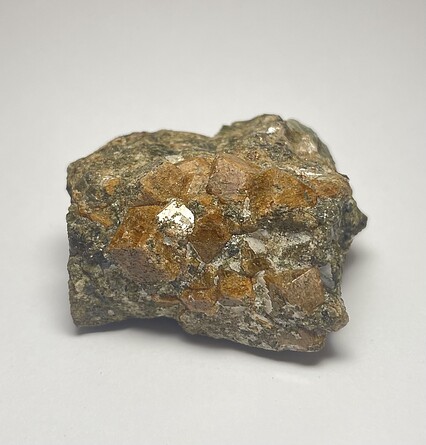
| ⓘ 'Garnet Group' Formula: X3Z2(SiO4)3 |
| ⓘ Quartz Formula: SiO2 |
| ⓘ Scheelite Formula: Ca(WO4) Description: Occurs as crystals 1 to 10 cm diameter disseminated in tactite. |
Gallery:
List of minerals arranged by Strunz 10th Edition classification
| Group 4 - Oxides and Hydroxides | |||
|---|---|---|---|
| ⓘ | Quartz | 4.DA.05 | SiO2 |
| Group 7 - Sulphates, Chromates, Molybdates and Tungstates | |||
| ⓘ | Scheelite | 7.GA.05 | Ca(WO4) |
| Group 9 - Silicates | |||
| ⓘ | Epidote | 9.BG.05a | (CaCa)(AlAlFe3+)O[Si2O7][SiO4](OH) |
| Unclassified | |||
| ⓘ | 'Garnet Group' | - | X3Z2(SiO4)3 |
List of minerals for each chemical element
| H | Hydrogen | |
|---|---|---|
| H | ⓘ Epidote | (CaCa)(AlAlFe3+)O[Si2O7][SiO4](OH) |
| O | Oxygen | |
| O | ⓘ Epidote | (CaCa)(AlAlFe3+)O[Si2O7][SiO4](OH) |
| O | ⓘ Quartz | SiO2 |
| O | ⓘ Scheelite | Ca(WO4) |
| O | ⓘ Garnet Group | X3Z2(SiO4)3 |
| Al | Aluminium | |
| Al | ⓘ Epidote | (CaCa)(AlAlFe3+)O[Si2O7][SiO4](OH) |
| Si | Silicon | |
| Si | ⓘ Epidote | (CaCa)(AlAlFe3+)O[Si2O7][SiO4](OH) |
| Si | ⓘ Quartz | SiO2 |
| Si | ⓘ Garnet Group | X3Z2(SiO4)3 |
| Ca | Calcium | |
| Ca | ⓘ Epidote | (CaCa)(AlAlFe3+)O[Si2O7][SiO4](OH) |
| Ca | ⓘ Scheelite | Ca(WO4) |
| Fe | Iron | |
| Fe | ⓘ Epidote | (CaCa)(AlAlFe3+)O[Si2O7][SiO4](OH) |
| W | Tungsten | |
| W | ⓘ Scheelite | Ca(WO4) |
Other Databases
| Link to USGS MRDS: | 10103231 |
|---|
Other Regions, Features and Areas containing this locality
North AmericaContinent
North America PlateTectonic Plate
- Mojave DomainDomain
- Sierra Nevada BatholithVolcanic Arc
USA
- Sierra NevadaMountain Range
This page contains all mineral locality references listed on mindat.org. This does not claim to be a complete list. If you know of more minerals from this site, please register so you can add to our database. This locality information is for reference purposes only. You should never attempt to
visit any sites listed in mindat.org without first ensuring that you have the permission of the land and/or mineral rights holders
for access and that you are aware of all safety precautions necessary.
References
(n.d.) Minerals Availability System (MAS), U.S. Bureau of Mines.file #0060290799

Tungsten Chief Mine, Havilah, Clear Creek Mining District, Kern County, California, USA