
Ron Coleman Mine, Blue Springs, Garland County, Arkansas, USAi
| Regional Level Types | |
|---|---|
| Ron Coleman Mine | Mine |
| Blue Springs | Unincorporated Area |
| Garland County | County |
| Arkansas | State |
| USA | Country |
This page is currently not sponsored. Click here to sponsor this page.



Latitude & Longitude (WGS84):
34° 39' 42'' North , 93° 6' 10'' West
Latitude & Longitude (decimal):
Type:
Köppen climate type:
Nearest Settlements:
| Place | Population | Distance |
|---|---|---|
| Hot Springs Village | 12,807 (2017) | 9.6km |
| Mountain Pine | 778 (2017) | 11.9km |
| Fountain Lake | 503 (2017) | 14.4km |
| Hot Springs National Park | 35,193 (2017) | 14.9km |
| Piney | 4,699 (2017) | 17.7km |
Other/historical names associated with this locality:
Old Coleman Mine; West Chance; Dierks No. 4; Blocker Lead; Geomex
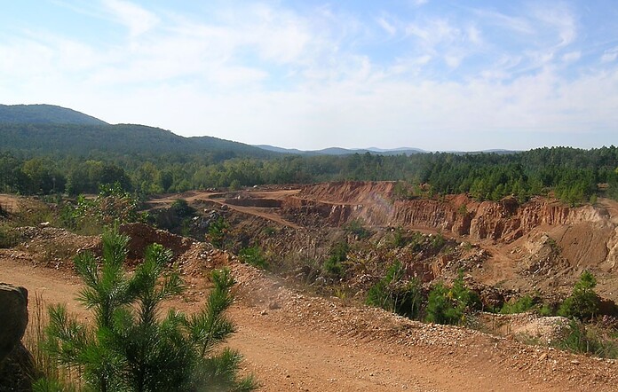
A quartz mine located 4½ miles NNW of Jessieville. Mineralization is quartz veins in Stanley Shale.
Access: Located on the road which runs alongside Colemans Rock Shop and driving two miles west of Hwy 7, then turn right on Crystal Ridge Road and driving to the top of the hill to the mine, all roads paved, stopping at the office/rock shop at the top of the hill past the campground, to pay your dig fee.
This mine was and is the most productive quartz mine in Arkansas. It has been producing quartz crystals in large quantities since 1943. When it is operating it has produced about 60,000 pounds of quartz crystals a during a good month. In the 1980s the mine was sold to the Japanese to produce quartz for industrial purposes (fiber optics?). In the early 90s, Ronny Coleman bought the mine back from the Japanese and has operated it intermittently ever since.
[Rock Currier 2011]
Originally the mine was called the Dierks No.4 Mine or the Blocker Lead mine which was named after John Blocker, a local crystal dealer. Quartz veins in this region are called leads. The mine did not originally produce much in the way of quartz because the deposit was "capped" with massive white quartz. It was not till 1943 that the mine started to produce a lot of crystals when local diggers penetrated the massive white quartz cap of the vein and produced large quantities of both ornamental and oscillator quartz crystals. Operations were entirely by hand along a vein that was 10 to 50 feet wide and 800 feet long. All the production was from closely spaced hand-dug holes with a maximum depth of about 20 feet. In a period of four months, the miners produced about 50 tons of crystals of which 2100 pounds were of oscillator grade.
In 1943 the local miners stopped working the productive zone because of claims litigation. In January of 1944, the Diamond Drill Carbon Co. set up operations there and explored the vein with open cuts up to 40 feet deep. During the next four months, they mined 60 tons of crystals and more than 2,500 pounds of eye-clear quartz. This was the most outstanding production in volume and crystal size of any single deposit in the district. The pockets mined at this time measured as much as 4x10x30 feet have contained mostly large crystals, the largest weighing as much as 600 pounds. Many crystals between 20 & 40 pounds contain 10 to 30% oscillator quartz. The largest single piece of oscillator quartz mined weighed 18 pounds after cobbing. However, more than 88% of the eye-clear quartz shows appreciable optical twinning. No associated primary minerals have been found in the exposed deposits, which are deeply weathered, but many crystals and fragments of vein quartz contain rhombohedral casts of calcite. Clots of kaolin and dark-red halloysite, clays fill fissures throughout the deposits. Crystal and vein quartz with carbonaceous inclusions occur locally.
From 1946 to 1976 Dierks Lumber company leased out the mine to Charles Coleman and family. 1976-1980 leased to a Japanese company. 1980 mine sold to a German company and in 1990 Ron Coleman purchased the mine.
Select Mineral List Type
Standard Detailed Gallery Strunz Chemical ElementsCommodity List
This is a list of exploitable or exploited mineral commodities recorded at this locality.Mineral List
3 valid minerals.
Detailed Mineral List:
| ⓘ Ankerite Formula: Ca(Fe2+,Mg)(CO3)2 |
| ⓘ Calcite Formula: CaCO3 |
| ⓘ Quartz Formula: SiO2 References: |
| ⓘ Quartz var. Milky Quartz Formula: SiO2 |
| ⓘ Quartz var. Rock Crystal Formula: SiO2 Description: Occurs in quartz veins in Stanley Shale. References: |

List of minerals arranged by Strunz 10th Edition classification
| Group 4 - Oxides and Hydroxides | |||
|---|---|---|---|
| ⓘ | Quartz | 4.DA.05 | SiO2 |
| ⓘ | var. Rock Crystal | 4.DA.05 | SiO2 |
| ⓘ | var. Milky Quartz | 4.DA.05 | SiO2 |
| Group 5 - Nitrates and Carbonates | |||
| ⓘ | Calcite | 5.AB.05 | CaCO3 |
| ⓘ | Ankerite | 5.AB.10 | Ca(Fe2+,Mg)(CO3)2 |
List of minerals for each chemical element
| C | Carbon | |
|---|---|---|
| C | ⓘ Ankerite | Ca(Fe2+,Mg)(CO3)2 |
| C | ⓘ Calcite | CaCO3 |
| O | Oxygen | |
| O | ⓘ Ankerite | Ca(Fe2+,Mg)(CO3)2 |
| O | ⓘ Calcite | CaCO3 |
| O | ⓘ Quartz | SiO2 |
| O | ⓘ Quartz var. Rock Crystal | SiO2 |
| O | ⓘ Quartz var. Milky Quartz | SiO2 |
| Mg | Magnesium | |
| Mg | ⓘ Ankerite | Ca(Fe2+,Mg)(CO3)2 |
| Si | Silicon | |
| Si | ⓘ Quartz | SiO2 |
| Si | ⓘ Quartz var. Rock Crystal | SiO2 |
| Si | ⓘ Quartz var. Milky Quartz | SiO2 |
| Ca | Calcium | |
| Ca | ⓘ Ankerite | Ca(Fe2+,Mg)(CO3)2 |
| Ca | ⓘ Calcite | CaCO3 |
| Fe | Iron | |
| Fe | ⓘ Ankerite | Ca(Fe2+,Mg)(CO3)2 |
Other Databases
| Link to USGS MRDS: | 10257180 |
|---|
Other Regions, Features and Areas containing this locality
North AmericaContinent
North America PlateTectonic Plate
- Arkoma Basin–Ouachita Thrust BeltBasin
- Granite-Rhyolite ProvinceMagmatic Province
- Sabine DomainDomain
This page contains all mineral locality references listed on mindat.org. This does not claim to be a complete list. If you know of more minerals from this site, please register so you can add to our database. This locality information is for reference purposes only. You should never attempt to
visit any sites listed in mindat.org without first ensuring that you have the permission of the land and/or mineral rights holders
for access and that you are aware of all safety precautions necessary.

Ron Coleman Mine, Blue Springs, Garland County, Arkansas, USA